
Centralia, Pennsylvania facts for kids
Quick facts for kids
Centralia, Pennsylvania
Bull's Head
|
|
|---|---|
|
Borough
|
|

Centralia as seen from South Street, July 2010
|
|

Location of Centralia in Columbia County, Pennsylvania.
|
|

Centralia, Pennsylvania
Location in Pennsylvania

Centralia, Pennsylvania
Location in the United States
|
|
| Country | United States |
| State | Pennsylvania |
| County | Columbia |
| Settled | 1841 (as Bull's Head) |
| Incorporated | 1866 (Borough of Centralia) |
| Founded by | Jonathan Faust |
| Area | |
| • Total | 0.24 sq mi (0.62 km2) |
| • Land | 0.24 sq mi (0.62 km2) |
| • Water | 0.00 sq mi (0.00 km2) 0% |
| Elevation | 1,467 ft (447 m) |
| Population
(2020)
|
|
| • Total | 5 |
| • Density | 46.03/sq mi (17.77/km2) |
| Time zone | UTC-5 (Eastern (EST)) |
| • Summer (DST) | UTC-4 (EDT) |
| ZIP code | |
| Area code | 570 |
| FIPS code | 42-12312 |
|
|
Centralia is a borough and near-ghost town in Columbia County, Pennsylvania, United States. Its population has declined from 1,000 in 1980 to 5 residents in 2017 because a coal mine fire has been burning beneath the borough since 1962. Centralia, part of the Bloomsburg–Berwick metropolitan area, is the least-populated municipality in Pennsylvania. It is completely surrounded by Conyngham Township.
All real estate in the borough was claimed under eminent domain in 1992 and condemned by the Commonwealth of Pennsylvania. Centralia's ZIP code was discontinued by the Postal Service in 2002. State and local officials reached an agreement with the seven remaining residents on October 29, 2013, allowing them to remain in Centralia until their deaths, after which the rights to their houses will be taken through eminent domain.
Contents
History
Early history
Many of the Native American tribes in what is now Columbia County sold the land that makes up Centralia to colonial agents in 1749 for the sum of five hundred pounds. In 1770, during the construction of the Reading Road, which stretched from Reading to Fort Augusta (present-day Sunbury), settlers surveyed and explored the land. A large portion of the Reading Road was developed later as Route 61, the main highway east into and south out of Centralia.
In 1793, Robert Morris, a hero of the Revolutionary War and a signatory of the Declaration of Independence, acquired a third of Centralia's valley land. When he declared bankruptcy in 1798, the land was surrendered to the Bank of the United States. A French sea captain named Stephen Girard purchased Morris' lands for $30,000, including 68 tracts east of Morris.' He had learned that there was anthracite coal in the region.
The Centralia coal deposits were largely overlooked before the construction of the Mine Run Railroad in 1854. In 1832, Johnathan Faust opened the Bull's Head Tavern in what was called Roaring Creek Township; this gave the town its first name, Bull's Head. In 1842, Centralia's land was bought by the Locust Mountain Coal and Iron Company. Alexander Rae, a mining engineer, moved his family in and began planning a village, laying out streets and lots for development. Rae named the town Centreville, but in 1865 changed it to Centralia because the U.S. Post Office already had a Centreville in Schuylkill County. The Mine Run Railroad was built in 1854 to transport coal out of the valley.
Mining begins

The first two mines in Centralia opened in 1856, the Locust Run Mine and the Coal Ridge Mine. Afterward came the Hazeldell Colliery Mine in 1860, the Centralia Mine in 1862, and the Continental Mine in 1863. The Continental was located on Stephen Girard's former estate. Branching from the Lehigh Valley Railroad, the Lehigh and Mahanoy Railroad was constructed to Centralia in 1865; it enabled transport and expansion of Centralia's coal sales to markets in eastern Pennsylvania.
Centralia was incorporated as a borough in 1866. Its principal employer was the anthracite coal industry. Alexander Rae, the town's founder, was murdered in his buggy by members of the Molly Maguires on October 17, 1868, during a trip between Centralia and Mount Carmel. Three men were eventually convicted of his death and were hanged in the county seat of Bloomsburg, on March 25, 1878.
Several other murders and incidents of arson also took place during the violence, as Centralia was a hotbed of Molly Maguires activity during the 1860s to organize a mineworkers union in order to improve wages and working conditions. A legend among locals in Centralia tells that Father Daniel Ignatius McDermott, the first Roman Catholic priest to call Centralia home, cursed the land in retaliation for being assaulted by three members of the Maguires in 1869. McDermott said that there would be a day when St. Ignatius Roman Catholic Church would be the only structure remaining in Centralia. Many of the Molly Maguires' leaders were hanged in 1877, ending their crimes. Legends say that a number of descendants of the Molly Maguires still lived in Centralia up until the 1980s.
According to numbers of Federal census records, the town of Centralia reached its maximum population of 2,761 in the year 1890. At its peak the town had seven churches, five hotels, twenty-seven saloons, two theaters, a bank, a post office, and 14 general and grocery stores. Thirty-seven years later the production of anthracite coal had reached its peak in Pennsylvania. In the following years, production declined, as many young miners from Centralia enlisted in the military when the US entered World War I.
In 1929 the crash of the stock market resulted in the Lehigh Valley Coal Company closing five of its Centralia-local mines. Bootleg miners continued mining in several idle mines, using techniques such as what was called "pillar-robbing," where miners would extract coal from coal pillars left in mines to support their roofs. This caused the collapse of many idle mines, further complicating the prevention of the mine fire in 1962. Efforts to seal off the abandoned mines ran into the collapsed areas.
In the year 1950, Centralia Council acquired the rights to all anthracite coal beneath Centralia through a state law passed in 1949 that enabled the transaction. That year, the federal census counted 1,986 residents in Centralia.
Coal mining continued in Centralia until the 1960s, when most of the companies shut down. Bootleg mining continued until 1982, and strip and open-pit mining are still active in the area. An underground mine about three miles to the west employs about 40 people.

Rail service ended in 1966. Centralia operated its own school district, including elementary schools and a high school. There were also two Catholic parochial schools. By 1980, it had 1,012 residents. Another 500 or 600 lived nearby.
Mine fire

Triggers
Analysts disagree about the specific cause of the Centralia fire. Writer David Dekok concluded that it started incident to cleanup of the town landfill. In May 1962, the Centralia Borough Council hired five members of the volunteer fire company to clean up the town landfill, located in an abandoned strip-mine pit next to the Odd Fellows Cemetery just outside the borough limits. This had been done prior to Memorial Day in previous years, when the landfill was in a different location.
On May 27, 1962, the firefighters, as they had in the past, set the dump on fire and let it burn for some time. Unlike in previous years, however, the fire was not fully extinguished. An unsealed opening in the pit allowed the fire to enter the labyrinth of abandoned coal mines beneath Centralia.
By contrast, Joan Quigley states in her book The Day the Earth Caved In (2007) that the fire had started the previous day, when a trash hauler dumped hot ash or coal discarded from coal burners into the open trash pit. She noted that borough council minutes from June 4, 1962 referred to two fires at the dump, and that five firefighters had submitted bills for "fighting the fire at the landfill area." The borough, by law, was responsible for installing a fire-resistant clay barrier between each layer of the landfill, but fell behind schedule, leaving the barrier incomplete. This allowed the hot coals to penetrate the vein of coal underneath the pit and start the subsequent subterranean fire.
According to a legend, the Bast Colliery coal fire of 1932 was never fully extinguished. In 1962, it reached the landfill area.
Immediate effects
In 1979, locals became aware of the scale of the problem when a gas-station owner, then-mayor John Coddington, inserted a dipstick into one of his underground tanks to check the fuel level. When he withdrew it, it seemed hot. He lowered a thermometer into the tank on a string and was shocked to discover that the temperature of the gasoline in the tank was 172 °F (77.8 °C).
Statewide attention to the fire began to increase, culminating in 1981 when a 12-year-old resident named Todd Domboski fell into a sinkhole, 4 feet (1.2 m) wide by 150 feet (46 m) deep, that suddenly opened beneath his feet in a backyard. His cousin, 14-year-old Eric Wolfgang, pulled Domboski out of the hole and saved his life. The plume of hot steam billowing from the hole was tested and found to contain a lethal level of carbon monoxide.
Although there was physical, visible evidence of the fire, residents of Centralia were bitterly divided over the question of whether or not the fire posed a direct threat to the town. In The Real Disaster is Above Ground, Steve Kroll-Smith and Steve Couch identified at least six community groups, each organized around varying interpretations of the amount and kind of risk posed by the fire. In 1984, the Congress allocated more than $42 million for relocation efforts. Most of the residents accepted buyout offers and moved to the nearby communities of Mount Carmel and Ashland.
In 1992, Pennsylvania governor Bob Casey invoked eminent domain on all property in the borough, condemning all the buildings within. A subsequent legal effort by residents to overturn the action failed. In 2002, the U.S. Postal Service discontinued Centralia's ZIP code, 17927. In 2009, Governor Ed Rendell began the formal eviction of the remaining Centralia residents.
The Centralia mine fire extended beneath the village of Byrnesville, a short distance to the south, and required it also to be abandoned.
Condemnation and abandonment


Few homes remain standing in Centralia. Most of the abandoned buildings have been demolished by the Columbia County Redevelopment Authority or reclaimed by nature. At a casual glance, the area now appears to be a field with many paved streets running through it. Some areas are being filled with new-growth forest. The remaining church in the borough, St. Mary's, holds weekly services on Sunday. It has not yet been directly affected by the fire. The town's four cemeteries—including one on the hilltop that has smoke rising around and out of it—are maintained in good condition.
The only indications of the fire, which underlies some 400 acres (1.6 km2) spreading along four fronts, are low round metal steam vents in the south of the borough. Several signs warn of underground fire, unstable ground, and dangerous levels of carbon monoxide. Additional smoke and steam can be seen coming from an abandoned portion of Pennsylvania Route 61, the area just behind the hilltop cemetery, and other cracks in the ground scattered about the area. Route 61 was repaired several times until it was closed.
The current route was formerly a detour around the damaged portion during the repairs and became a permanent route in 1993; mounds of dirt were placed at both ends of the former route, effectively blocking the road. Pedestrian traffic is still possible due to a small opening about two feet wide at the north side of the road. The underground fire is still burning and may continue to do so for 250 years. The Commonwealth of Pennsylvania did not renew the relocation contract at the end of 2005.
The last remaining house on Locust Avenue was demolished in September 2007. It was notable for a period for the five chimney-like support buttresses along each of two opposite sides of the house. The house had formerly been supported by a row of adjacent buildings. Another house with similar buttresses was visible from the northern side of the cemetery, just north of the burning, partially subsumed hillside.
Residents John Comarnisky and John Lokitis, Jr. were evicted in May and July 2009, respectively. In May 2009, the remaining residents mounted another legal effort to reverse the 1992 eminent domain claim. In 2010, only five homes remain as state officials try to vacate the remaining residents and demolish what is left of the town. In March 2011, a federal judge refused to issue an injunction that would have stopped the condemnation.
The Borough Council still has regular meetings as of 2011[update]. It was reported that the town's highest bill at the meeting reported on came from PPL, a power utility, at $92 and the town's budget was "in the black."
In February 2012, the Commonwealth Court ruled that a declaration of taking could not be re-opened or set aside on the basis that the purpose for the condemnation no longer exists; seven people, including the Borough Council president, had filed suit claiming the condemnation was no longer needed because the underground fire had moved and the air quality in the borough was the same as that in Lancaster. In October 2013, the remaining residents settled their lawsuit, receiving $218,000 in compensation for the value of their homes, along with $131,500 to settle additional claims, and the right to stay in their homes for the rest of their lives.
Time capsule
The town's residents and former residents decided to open a time capsule buried in 1966 a few years earlier than planned after someone had attempted to unearth and steal the capsule in May 2014. The capsule was not scheduled to be opened until 2016. Items found in the footlocker-sized capsule, which had been inundated with about 12 inches (30 cm) of water, included a miner’s helmet, a miner’s lamp, some coal, a Bible, local souvenirs, and a pair of bloomers signed by the men of Centralia in 1966.
Mineral rights
Several current and former Centralia residents believe the state's eminent domain claim was a plot to gain the mineral rights to the anthracite coal beneath the borough. Residents have asserted its value to be in the hundreds of millions of dollars, although the exact amount of coal is not known.
This theory is based on the municipality laws of the state. According to state law, when the municipality can no longer form a functioning municipal government, i.e., when there are no longer any residents, the borough legally ceases to exist.
Demographics
| Historical population | |||
|---|---|---|---|
| Census | Pop. | %± | |
| 1870 | 1,342 | — | |
| 1880 | 1,886 | 40.5% | |
| 1890 | 2,761 | 46.4% | |
| 1900 | 2,048 | −25.8% | |
| 1910 | 2,429 | 18.6% | |
| 1920 | 2,336 | −3.8% | |
| 1930 | 2,446 | 4.7% | |
| 1940 | 2,449 | 0.1% | |
| 1950 | 1,986 | −18.9% | |
| 1960 | 1,435 | −27.7% | |
| 1970 | 1,165 | −18.8% | |
| 1980 | 1,017 | −12.7% | |
| 1990 | 63 | −93.8% | |
| 2000 | 21 | −66.7% | |
| 2010 | 10 | −52.4% | |
| 2020 | 5 | −50.0% | |
| Sources: | |||
2010 census
As of the census of 2010 there were ten people (down 52% since 2000), five households (down 50%), and three families (down 57%) residing in the borough. The population density was 42 inhabitants per square mile (16/km2) (down 52%). There were six housing units (down 62.5%) at an average density of 0.4 units per square mile (.015 units/km2). The racial makeup of the borough was 100% white.
Of the five households, none had children under the age of 18. Two (40%) were married couples living together, one (20%) had a female householder with no spouse present, and two (40%) were non-families. One of those non-family households was an individual, and none had someone living alone who was 65 years of age or older. The average household size was 2.0 persons, and the average family size was 2.33 persons.
There were no residents under the age of 18, one aged 25–29, one aged 50–54, one aged 55–59, four aged 60–64, two aged 70–74, and one aged 80–84. The median age was 62.5 years, and there were five females and five males in total.
2020 census
As of the census of 2020, there were five people residing in the borough. The racial makeup of the borough was 80% white, and 20% Asian.
One resident (20%) was under the age of 18.
Images for kids
-
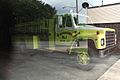
Fire engine inside municipal building
-
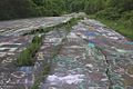
Road damage and graffiti on abandoned section of PA Route 61
-
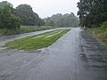
Abandoned section of Railroad Avenue in Centralia, 2016


See also
 In Spanish: Centralia para niños
