
Centre-Val de Loire facts for kids
Quick facts for kids Centre-Val de Loire |
|||
| Region | |||
|
|||
| Country | |||
|---|---|---|---|
| Préfecture | Orléans | ||
| Area | 39,150.9 km² (15,116 sq mi) | ||
| Population | 2,577,435 (2014) | ||
| Density | 66 /km² (171 /sq mi) | ||
| Subdivisions | 6 departments 20 arrondissements 102 cantons 1783 communes |
||
| President | François Bonneau | ||
| Timezone | CET (UTC+1) | ||
| - summer (DST) | CEST (UTC+2) | ||
| ISO 3166-2 | FR-CVL | ||


Centre-Val de Loire is one of the administrative regions of France. Its capital is Orléans but its largest city is Tours.
It was formed in 2014 from the territories of three historical provinces: Touraine (Indre-et-Loire), Orléanais (Loiret, Eure-et-Loir, Loir-et-Cher), and Berry (Cher, Indre).
Contents
Geography

The Centre-Val de Loire region is the seventh largest region of France with an area of 39,150.9 km2 (15,116 sq mi). It is in north central France and borders with 6 regions: Normandy to the northwest, Île-de-France to the north, Bourgogne-Franche-Comté to the east, Auvergne-Rhône-Alpes to the southeast, Nouvelle-Aquitaine to the south and Pays de la Loire to the west.
The distances from Orléans, the capital of the region, to other cities are:
- Paris, the national capital, 132 km (82 mi);
- Bordeaux, 462 km (287 mi);
- Lyon, 466 km (290 mi);
- Marseille, 759 km (472 mi);
- Montpellier, 626 km (389 mi);
- Nice, 915 km (569 mi);
- Strasbourg, 584 km (363 mi);
- Toulouse, 555 km (345 mi).
Rivers
The Centre-Val de Loire is crossed by the longest French river: the Loire, 1,013 km (629 mi). Some other rivers that flow through the region are:
- Eure - 229 km (142 mi).
- Loir - 317 km (197 mi).
- Cher - 368 km (229 mi).
- Loing - 142 km (88 mi).
- Indre - 279 km (173 mi).
Mountains
The territory of the Centre-Val de Loire region is formed mostly by large plains and low plateaus.
The Le Magnoux (46°25′43″N 2°11′54″E / 46.42861°N 2.19833°E), at 501 m (1,644 ft), is the highest point of the Centre-Val region. It is in northwestern Massif Central, in the southern end of the Cher department.
The highest point of the different departments in the Centre-Val de Loire region are:
| Department | Mountain | Elevation |
|---|---|---|
| Cher | Le Magnoux | 501 m (1,644 ft) |
| Eure-et-Loir | Butte de Rougemont | 287 m (942 ft) |
| Indre | Terrior Randoin | 457 m (1,499 ft) |
| Indre-et-Loire | Signal de la Ronde | 186 m (610 ft) |
| Loir-et-Cher | Bois des Vallèes | 256 m (840 ft) |
| Loiret | Col des Étourneaux | 273 m (896 ft) |
Departments
The Centre-Val de Loire region is formed by 6 departments:
| ISO 3166-2 |
Shield | Department | Prefecture | Arr. | Cant. | Comm. | Population (2014) |
Area (km²) |
Density (Inh./km²) |
|---|---|---|---|---|---|---|---|---|---|
| FR-18 | Cher | Bourges | 3 | 19 | 290 | 310,270 | 7,235.0 | 42.9 | |
| FR-28 | Eure-et-Loir | Chartres | 4 | 15 | 375 | 433,762 | 5,880.0 | 73.8 | |
| FR-36 | Indre | Châteauroux | 4 | 13 | 243 | 226,175 | 6,790.6 | 33.3 | |
| FR-37 | Indre-et-Loire | Tours | 3 | 19 | 273 | 603,924 | 6126.7 | 98.6 | |
| FR-41 | Loir-et-Cher | Blois | 3 | 15 | 276 | 333,567 | 6,343.4 | 52.6 | |
| FR-45 | Loiret | Orléans | 3 | 21 | 326 | 669,737 | 6,775.2 | 98.9 | |
| Total of the Region | 20 | 102 | 1,783 | 2,577,435 | 39,150.9 | 65.8 | |||
Arr. = Arrondissements Cant. = Cantons Comm. = Communes
Demographics
As of 1 January 2014[update], the Centre-Val de Loire region had a population of 2,577,435, for a population density of 65.8 inhabitants/km2.

The main cities with more than 20,000 inhabitants (2014) in the region are:
| INSEE code |
City | Department | Population (2014) |
|---|---|---|---|
| 37261 | Tours | Indre-et-Loire | 136,125 |
| 45234 | Orléans | Loiret | 114,977 |
| 18033 | Bourges | Cher | 66,528 |
| 41018 | Blois | Loir-et-Cher | 46,351 |
| 36044 | Châteauroux | Indre | 44,479 |
| 28085 | Chartres | Eure-et-Loir | 38,728 |
| 37122 | Joué-lès-Tours | Indre-et-Loire | 37,748 |
| 28134 | Dreux | Eure-et-Loir | 31,191 |
| 18279 | Vierzon | Cher | 27,050 |
| 45232 | Olivet | Loiret | 21,192 |
| 45147 | Fleury-les-Aubrais | Loiret | 20,791 |
Gallery
-
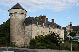
Castle of Tours.
-
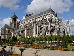
Saint-Etienne cathedral, Bourges.
-
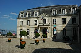
Blois City hall.
-
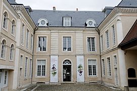
Musée Hôtel Bertrand, Châteauroux.

_16-09-2006.jpg)


Related pages
Images for kids
-
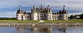
Château de Chambord
-
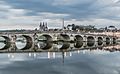
Blois
-
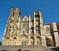
Bourges
-
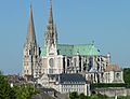
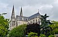
Chartres
-
Châteauroux
-
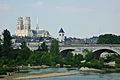
Orléans
-
Tours


See also
 In Spanish: Centro-Valle del Loira para niños
