Cham (district) facts for kids
Quick facts for kids
Cham
|
||
|---|---|---|
|
||
| Country | ||
| State | Bavaria | |
| Adm. region | Upper Palatinate | |
| Region | Regensburg | |
| Capital | Cham | |
| Area | ||
| • Total | 1,510 km2 (580 sq mi) | |
| Population
(2000)
|
||
| • Total | 131,000 | |
| • Density | 86.8/km2 (224.7/sq mi) | |
| Time zone | UTC+1 (CET) | |
| • Summer (DST) | UTC+2 (CEST) | |
| Vehicle registration | CHA, KÖZ, ROD, WÜM | |
| Website | landkreis-cham.de | |
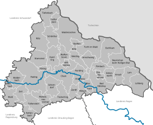
Cham is a Landkreis (district) in Bavaria, Germany.
The district is located in the northern parts of the Bavarian Forest.
Towns and municipalities
| Towns | Municipalities | |
|---|---|---|
|
|
|
See also
 In Spanish: Distrito de Cham para niños

All content from Kiddle encyclopedia articles (including the article images and facts) can be freely used under Attribution-ShareAlike license, unless stated otherwise. Cite this article:
Cham (district) Facts for Kids. Kiddle Encyclopedia.


