
Chatswood West, New South Wales facts for kids
Quick facts for kids Chatswood WestSydney, New South Wales |
|||||||||||||||
|---|---|---|---|---|---|---|---|---|---|---|---|---|---|---|---|

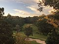
Fullers Bridge, Chatswood West
|
|||||||||||||||
| Population | 1,499 (2016 census) | ||||||||||||||
| • Density | 535/km2 (1,390/sq mi) | ||||||||||||||
| Established | 20 January 2006 | ||||||||||||||
| Postcode(s) | 2067 | ||||||||||||||
| Area | 2.8 km2 (1.1 sq mi) | ||||||||||||||
| Location | 10 km (6 mi) north-west of Sydney CBD | ||||||||||||||
| LGA(s) | City of Willoughby, City of Ryde | ||||||||||||||
| State electorate(s) |
|
||||||||||||||
| Federal Division(s) | |||||||||||||||
|
|||||||||||||||
Chatswood West is a suburb on the Lower North Shore of Sydney, in the state of New South Wales, Australia. Chatswood West is located 11 kilometres north-west of the Sydney central business district, in the local government areas of the City of Willoughby and City of Ryde. Chatswood is a separate suburb to the east. The locality of Chatswood located west of the Pacific Highway is informally known as West Chatswood, and should not be confused with the separate suburb of Chatswood West, nor should it be confused with the West Chatswood Post Office on Railway Street in the suburb of Chatswood. Chatswood West shares the same postcode as Chatswood which is 2067.
Chatswood West is located between the bigger suburbs of Chatswood and North Ryde. It straddles the Lane Cove River, occupying the valley flats and ridges leading down to the river.
History
Chatswood is believed to be named after the pet name "Chat" of the second wife of Richard Harnett (a pioneer of the district) and the original "wooded" nature of the area.
Chatswood West split off from Chatswood to become a separate suburb on 20 January 2006. Chislehurst was a large historic house on Centennial Avenue.
Houses
The residential buildings are overwhelmingly detached houses.
Transport
Chatswood railway station is a major station on the North Shore railway line of the Sydney Trains network, and is also serviced by the Sydney Metro Northwest which opened in 2018.
There are regular buses that connect the area with the Chatswood CBD, and other suburbs such as Parramatta. The main bus routes that connect Chatswood to Chatswood West are routes 255 and 256, operated by Busways.
Population
Demographics
According to the 2011 census, there were 1,426 residents in Chatswood West. 61.9% of people were born in Australia. The most common other countries of birth were England 5.8%, China 4.6%, New Zealand 2.9%, Korea, Republic of (South) 1.6% and Germany 1.2%. In Chatswood West 72.9% of people only spoke English at home. Other languages spoken at home included Mandarin 4.8%, Cantonese 4.4% and Korean 2.2%. The most common responses for religion in Chatswood West were No Religion 27.8%, Catholic 25.2% and Anglican 18.6%.
Notable residents
- Kenneth Slessor - poet, lived on the west side of the Pacific Highway
- Roger Woodward - pianist, lived at Peckham Street
- Errol Flynn - movie star, lived in McLean Avenue
- Tony Abbott - politician, lived in West Parade
Parks
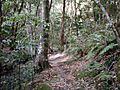
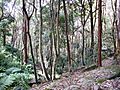
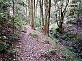
There are a number of parks and forest reserves such as Ferndale Park. There are walking tracks and a golf course. There are two entrances to Lane Cove National Park from Chatswood West, one on Lady Game Drive, and one on Delhi Road, next to Fullers Bridge.
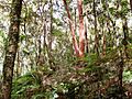
Noteworthy indigenous flora includes the blackbutt, tree heath, celery wood, coachwood, native crabapple and hard corkwood. Ferns include jungle brake, fishbone water fern, filmy fern and necklace fern.
Fauna includes powerful owl, barking owl, Australian king parrot, brush turkey, eastern whipbird, satin bowerbird, eastern water dragon, emerald spotted frog, enamelled spider, red triangle slug, blue planarian, long-nosed bandicoot and marsupial mouse.
-
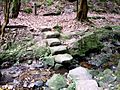
Crossing of Swaines Creek, Chatswood West
-
Coachwood - Ferndale Park
-
Forest scene - Ferndale Park
-
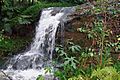
Tributary of Swaines Creek
-
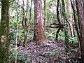
Large blackbutt - Ferndale Park
-
Coachwood rainforest - Ferndale Park
-
Lilli pilli rainforest - Ferndale Park
-
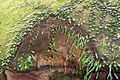
Hawkesbury sandstone and rock felt fern (Pyrrosia rupestris)


Images for kids
-
View from residential property onto

