
Cheboygan County, Michigan facts for kids
Quick facts for kids
Cheboygan County
|
||
|---|---|---|

|
||
|
||

Location within the U.S. state of Michigan
|
||
 Michigan's location within the U.S. |
||
| Country | ||
| State | ||
| Founded | 1840 (authorized) 1855 (organized) |
|
| Seat | Cheboygan | |
| Largest city | Cheboygan | |
| Area | ||
| • Total | 885 sq mi (2,290 km2) | |
| • Land | 715 sq mi (1,850 km2) | |
| • Water | 170 sq mi (400 km2) 19%% | |
| Population
(2020)
|
||
| • Total | 25,579 | |
| • Density | 37/sq mi (14/km2) | |
| Time zone | UTC−5 (Eastern) | |
| • Summer (DST) | UTC−4 (EDT) | |
| Congressional district | 1st | |

Cheboygan County ( shi-BOY-gən) is a county in the U.S. state of Michigan. As of the 2020 Census, the population was 25,579. The county seat is Cheboygan. The county boundaries were set off in 1840, with land partitioned from Mackinac County. The Cheboygan County government was organized in 1853.
Contents
Etymology of the name Cheboygan
The name of the county shares the same origin as that of the Cheboygan River, although the precise meaning is no longer known. It may have come from an Ojibwe word zhaabonigan, meaning "sewing needle". Alternatively, the origin may have been Chabwegan, meaning "a place of ore". It has also been described as "a Native American word first applied to the river. See List of Michigan county name etymologies.
Geography
According to the U.S. Census Bureau, the county has a total area of 885 square miles (2,290 km2), of which 715 square miles (1,850 km2) is land and 170 square miles (440 km2) (19%) is water. The county is considered to be part of Northern Michigan.

Adjacent counties
- Mackinac County - north
- Presque Isle County - east
- Montmorency County - southeast
- Otsego County - south
- Charlevoix County - southwest
- Emmet County - west
Transportation
Highways
 I-75
I-75 US 23
US 23 US 31
US 31 M-27
M-27 M-33
M-33 M-68
M-68- Invalid type: M 1973 (former highway)
- M-212
County-designated highways
 C-58
C-58 C-64
C-64 C-66
C-66 F-05
F-05
Airports
- Cheboygan County Airport, located in Cheboygan, is a private airport. There are no commercial airline airports in Cheboygan County but the nearest ones are Alpena County Regional Airport, Chippewa County International Airport (Sault Ste. Marie, MI), and Cherry Capital Airport (Traverse City). Delta Air Lines schedules flights daily out of the Pellston Regional Airport.
Demographics
| Historical population | |||
|---|---|---|---|
| Census | Pop. | %± | |
| 1860 | 517 | — | |
| 1870 | 2,196 | 324.8% | |
| 1880 | 6,524 | 197.1% | |
| 1890 | 11,986 | 83.7% | |
| 1900 | 15,516 | 29.5% | |
| 1910 | 17,872 | 15.2% | |
| 1920 | 13,991 | −21.7% | |
| 1930 | 11,502 | −17.8% | |
| 1940 | 13,644 | 18.6% | |
| 1950 | 13,731 | 0.6% | |
| 1960 | 14,550 | 6.0% | |
| 1970 | 16,573 | 13.9% | |
| 1980 | 20,649 | 24.6% | |
| 1990 | 21,398 | 3.6% | |
| 2000 | 26,448 | 23.6% | |
| 2010 | 26,152 | −1.1% | |
| 2020 | 25,579 | −2.2% | |
| US Decennial Census 1790-1960 1900-1990 1990-2000 2010-2018 |
|||
As of the 2000 United States Census, there were 26,448 people, 10,835 households, and 7,573 families in the county. The population density was 37 people per square mile (14/km2). There were 16,583 housing units at an average density of 23 per square mile (9/km2). The racial makeup of the county was 94.80% White, 0.25% Black or African American, 2.55% Native American, 0.20% Asian, 0.02% Pacific Islander, 0.15% from other races, and 2.05% from two or more races. 0.76% of the population were Hispanic or Latino of any race. 21.4% were of German, 10.4% English, 10.0% French, 9.5% Polish, 9.2% American and 8.9% Irish ancestry. 97.7% spoke English as their first language.
There were 10,835 households, out of which 28.60% had children under the age of 18 living with them, 58.00% were married couples living together, 8.60% had a female householder with no husband present, and 30.10% were non-families. 25.80% of all households were made up of individuals, and 11.80% had someone living alone who was 65 years of age or older. The average household size was 2.41 and the average family size was 2.87.
The county population contained 23.70% under the age of 18, 6.20% from 18 to 24, 25.80% from 25 to 44, 26.30% from 45 to 64, and 17.90% who were 65 years of age or older. The median age was 41 years. For every 100 females there were 98.30 males. For every 100 females age 18 and over, there were 96.50 males.
The median income for a household in the county was $33,417, and the median income for a family was $38,390. Males had a median income of $30,054 versus $20,682 for females. The per capita income for the county was $18,088. About 8.70% of families and 12.20% of the population were below the poverty line, including 17.90% of those under age 18 and 7.10% of those age 65 or over.
Communities
City
- Cheboygan (county seat)
Villages
- Mackinaw City (part)
- Wolverine
Census-designated place
- Indian River
Other unincorporated communities
- Afton
- Aloha
- Alverno
- Burt Lake
- Cordwood Point
- Elmhurst
- Mullett Lake
- Riggsville
- Topinabee
- Tower
Townships
- Aloha Township
- Beaugrand Township
- Benton Township
- Burt Township
- Ellis Township
- Forest Township
- Grant Township
- Hebron Township
- Inverness Township
- Koehler Township
- Mackinaw Township
- Mentor Township
- Mullett Township
- Munro Township
- Nunda Township
- Tuscarora Township
- Walker Township
- Waverly Township
- Wilmot Township
Cheboygan County had another township called Maple Grove Township which became part of Forest Township in 1942.
Historical markers

There are eight recognized Michigan historical markers in the county:
- Forty Mile Point Lighthouse / Graveyard of Ships
- Inland Waterway
- Jacob J. Post House
- Jail and Sheriff's Residence
- Newton-Allaire House
- Old Cheboygan County Courthouse
- St. Bernard Catholic Church
- St. Mary's Church
Images for kids
-
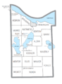
U.S. Census data map showing local municipal boundaries within Cheboygan County. Shaded areas represent incorporated cities.

See also
 In Spanish: Condado de Cheboygan para niños
