Chelmer, Queensland facts for kids
Quick facts for kids ChelmerBrisbane, Queensland |
|||||||||||||||
|---|---|---|---|---|---|---|---|---|---|---|---|---|---|---|---|

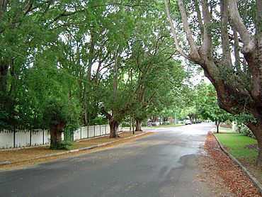
Camphor laurel trees along Laurel Avenue
|
|||||||||||||||
| Population | 2,998 (2016 census) | ||||||||||||||
| • Density | 1,670/km2 (4,300/sq mi) | ||||||||||||||
| Postcode(s) | 4068 | ||||||||||||||
| Area | 1.8 km2 (0.7 sq mi) | ||||||||||||||
| Time zone | AEST (UTC+10:00) | ||||||||||||||
| Location | 9.8 km (6 mi) SW of Brisbane GPO | ||||||||||||||
| LGA(s) | City of Brisbane (Tennyson Ward) |
||||||||||||||
| State electorate(s) | Miller | ||||||||||||||
| Federal Division(s) | Moreton | ||||||||||||||
|
|||||||||||||||
Chelmer is a south-western suburb in the City of Brisbane, Queensland, Australia. In the 2016 census Chelmer had a population of 2,998 people.
Demographics
In the 2011 census, Chelmer recorded a population of 2,594 people, 50.5% female and 49.5% male. The median age of the Chelmer population was 38 years of age, 1 year above the Australian median. 77% of people living in Chelmer were born in Australia, compared to the national average of 69.8%; the next most common countries of birth were England 5.3%, New Zealand 2.4%, United States of America 1.2%, Scotland 1%, Malaysia 0.7%. 89.6% of people spoke only English at home; the next most popular languages were 0.6% Hindi, 0.5% Korean, 0.4% Spanish, 0.3% Dutch, 0.3% Persian (excluding Dari).
Geography
Chelmer is located on a bend of the Brisbane River, with all sides except south bounded by the river.
Attractions
Laurel Avenue is considered one of the most prestigious addresses in Brisbane by some, for the reason that large portions of the avenue are overhung by large camphor laurel (Cinnamomum camphora) trees (some over a hundred years old). The Camphor Laurel trees have been declared a noxious weed by the Brisbane City Council, as their roots actively seek underground sewage pipes.
Heritage listings

Chelmer has a number of heritage-listed sites, including:
- 17 Laurel Avenue: Chelmer Police College
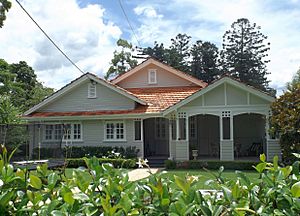
- 139 Laurel Avenue: Swain House
Transport
Chelmer is divided into east and west by Queensland Rail City network's Ipswich and Rosewood railway line and the Chelmer railway station. The Albert Bridge and the Indooroopilly Railway Bridge join the railway to Indooroopilly. A pedestrian/bicycle bridge, alongside the road and rail bridges, also links Chelmer (on the Southern bank of the Brisbane River) to Indooroopilly.
Sport
The Sherwood Districts Australian Football Club in Chelmer Street East (27°30′49″S 152°58′28″E / 27.5137°S 152.9744°E) and the Kenmore Australian Football Club in Oxley Road (27°30′42″S 152°58′32″E / 27.5118°S 152.9755°E) are Australian rules football clubs that compete in Division One of the AFLQ State League and Division One of the AFLQ State Association respectively.
Education
Milpera State High School is a government secondary (7-12) school for boys and girls at Parker Street (27°30′50″S 152°58′39″E / 27.5140°S 152.9775°E). In 2018, the school had an enrolment of 163 students with 35 teachers (28 full-time equivalent) and 34 non-teaching staff (19 full-time equivalent). It is a special purpose state high school which teaches English language to immigrants who are speakers of language other than English. These students enter and leave the school as determined by their English language skills.
There are no primary schools in Chelmer. The nearest government primary school is Graceville State School in neighbouring Graceville to the south. The nearest conventional government secondary school is Indooroopilly State High School in neighbouring Indooroopilly to the north.


