
Chemung County, New York facts for kids
Quick facts for kids
Chemung County
|
||
|---|---|---|

Chemung County Courthouse
|
||
|
||

Location within the U.S. state of New York
|
||
 New York's location within the U.S. |
||
| Country | ||
| State | ||
| Founded | March 29, 1836 | |
| Seat | Elmira | |
| Largest city | Elmira | |
| Area | ||
| • Total | 411 sq mi (1,060 km2) | |
| • Land | 407 sq mi (1,050 km2) | |
| • Water | 3.4 sq mi (9 km2) 0.8% | |
| Population
(2020)
|
||
| • Total | 84,148 | |
| • Density | 206.6/sq mi (79.8/km2) | |
| Time zone | UTC−5 (Eastern) | |
| • Summer (DST) | UTC−4 (EDT) | |
| Congressional district | 23rd | |

Chemung County is a county in the southern tier of the U.S. state of New York. The population was 84,148 as of the 2020 census. Its county seat is Elmira. Its name is derived from a Delaware Indian village whose name meant "big horn".
Chemung County comprises the Elmira, NY Metropolitan Statistical Area, which is also included in the Elmira-Corning, NY Combined Statistical Area.
Many signs posted along roads in Chemung County refer to the area as "Mark Twain Country," because the noted author lived and wrote for many years in Elmira.
Contents
History
For the history of Chemung County prior to its creation by partition, see Tioga County, New York.
Chemung County was formed from 520 square miles (1,300 km2) of Tioga County in 1836.
In 1854, Chemung County was divided and 110 square miles (280 km2) became Schuyler County, reducing Chemung to 410 square miles (1,100 km2), its current size.
In the late 1870s, the Greenbacker Party became prominent in Chemung and nearby counties in western New York. Here it was primarily allied with labor in a critique of capital, reaching its peak in 1878, the year following the Great Railroad Strike of 1877 and the Scranton General Strike in Pennsylvania. There were also strikes that year in Albany, Syracuse and Buffalo, starting with the railroad workers. In Steuben and Chemung counties, Greenbackers were elected to county councils in 1878 instead of Democrats, and others were elected from there and nearby counties to the state legislature, gaining votes of more than 25 percent in several of the Southern Tier counties. It gradually declined after that, due to internal dissension and the strength of the two major parties.
Geography
According to the U.S. Census Bureau, the county has a total area of 411 square miles (1,060 km2), of which 407 square miles (1,050 km2) is land and 3.4 square miles (8.8 km2) (0.8%) is water.
Chemung County is in the southwestern part of New York State, along the Pennsylvania border, in a part of New York called the Southern Tier and is also part of the Finger Lakes Region.
The Southern Tier Expressway runs through the County east-west near the Pennsylvania border, between Waverly, New York and Corning, New York via Elmira, New York.
Adjacent counties
- Schuyler County - north
- Tompkins County - northeast
- Tioga County - east
- Bradford County, Pennsylvania - south
- Tioga County, Pennsylvania - southwest
- Steuben County - west
Transportation
Major highways

 Interstate 86 / New York State Route 17 (Southern Tier Expressway)
 New York State Route 13
 New York State Route 14
 New York State Route 34
 New York State Route 223
 New York State Route 328
 New York State Route 352
 New York State Route 367
 New York State Route 414
 New York State Route 427
Airport
- Elmira Corning Regional Airport
Demographics
| Historical population | |||
|---|---|---|---|
| Census | Pop. | %± | |
| 1840 | 20,732 | — | |
| 1850 | 28,821 | 39.0% | |
| 1860 | 26,917 | −6.6% | |
| 1870 | 35,281 | 31.1% | |
| 1880 | 43,065 | 22.1% | |
| 1890 | 48,265 | 12.1% | |
| 1900 | 54,063 | 12.0% | |
| 1910 | 54,662 | 1.1% | |
| 1920 | 65,872 | 20.5% | |
| 1930 | 74,680 | 13.4% | |
| 1940 | 73,718 | −1.3% | |
| 1950 | 86,827 | 17.8% | |
| 1960 | 98,706 | 13.7% | |
| 1970 | 101,537 | 2.9% | |
| 1980 | 97,656 | −3.8% | |
| 1990 | 95,195 | −2.5% | |
| 2000 | 91,070 | −4.3% | |
| 2010 | 88,830 | −2.5% | |
| 2020 | 84,148 | −5.3% | |
| U.S. Decennial Census 1790-1960 1900-1990 1990-2000 2010-2020 |
|||
As of the 2000 census, there were 91,070 people, 35,049 households and 23,272 families residing in the county. The population density was 223 per square mile (86/km2). There were 37,745 housing units at an average density of 92 per square mile (36/km2). The racial makeup of the county was 90.96% White, 5.82% Black or African American, 0.23% Native American, 0.78% Asian, 0.02% Pacific Islander, 0.75% from other races, and 1.44% from two or more races. 1.77% of the population were Hispanic or Latino of any race. 16.4% were of German, 15.7% Irish, 12.5% English, 11.8% Italian, 7.8% American and 6.3% Polish ancestry according to Census 2000 [1]. Most of those claiming to be of "American" ancestry are of English descent and, in upstate New York, also in some cases of Dutch descent, but have family that has been in the country for so long, in many cases since the early seventeenth century, that they choose to identify simply as "American". 96.2% spoke English and 1.6% Spanish as their first language.
There were 35,049 households, of which 31.00% had children under the age of 18 living with them, 49.80% were married couples living together, 12.40% had a female householder with no husband present, and 33.60% were non-families. 27.90% of all households were made up of individuals, and 12.20% had someone living alone who was 65 years of age or older. The average household size was 2.44 and the average family size was 2.97.
Age distribution was 24.40% under the age of 18, 8.80% from 18 to 24, 28.30% from 25 to 44, 22.90% from 45 to 64, and 15.60% who were 65 years of age or older. The median age was 38 years. For every 100 females there were 97.70 males. For every 100 females age 18 and over, there were 95.30 males.
The median household income was $36,415, and the median family income was $43,994. Males had a median income of $35,076 versus $24,215 for females. The per capita income for the county was $18,264. About 9.10% of families and 13.00% of the population were below the poverty line, including 18.40% of those under age 18 and 6.80% of those age 65 or over.
Communities
City
- Elmira (county seat)
Towns
Villages
Census-designated places
Hamlet
Education
Education in Chemung County is provided by various private and public institutions. High school students and adults have access to GST BOCES. BOCES provides vocation-style training in a wide range of fields as well as adult education.
Public school districts
- Horseheads Central School District
- Elmira City School District
- Elmira Heights Central School District
Private schools
- Chemung Valley Montessori School
- Elmira Christian Academy
- Holy Family Middle School
- Saint Mary Our Mother School
- Notre Dame High School
- Twin Tiers Christian Academy
Higher education
- Arnot Ogden School of Nursing
- Corning Community College (off-campus sites)
- Elmira College
- Elmira Business Institute
Public libraries
Chemung County Library District

- Steele Memorial Library
- Horseheads Free Library
- Big Flats Library
- West Elmira Library
- Van Etten Library
- Chemung County Bookmobile
Notable people
Images for kids
-
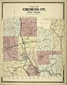
1869 map of Chemung County
-

Flag of Chemung County, at the Chemung County Courthouse
-
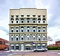
The Chemung County Government Building in Elmira


See also
 In Spanish: Condado de Chemung para niños
