
Chesapeake Beach, Maryland facts for kids
Quick facts for kids
Chesapeake Beach, Maryland
|
|
|---|---|
| Town of Chesapeake Beach | |
_at_Maryland_State_Route_261_(Bayside_Road)_in_Chesapeake_Beach,_Calvert_County,_Maryland.jpg) |
|
| Nickname(s):
"Twin Beaches"
|
|

Location of Chesapeake Beach, Maryland
|
|
| Country | |
| State | |
| County | |
| Incorporated | 1886 (repealed 1888, reincorporated 1894) |
| Area | |
| • Total | 2.78 sq mi (7.21 km2) |
| • Land | 2.69 sq mi (6.97 km2) |
| • Water | 0.09 sq mi (0.23 km2) |
| Elevation | 49 ft (15 m) |
| Population
(2020)
|
|
| • Total | 6,356 |
| • Density | 2,360.19/sq mi (911.40/km2) |
| Time zone | UTC-5 (Eastern (EST)) |
| • Summer (DST) | UTC-4 (EDT) |
| ZIP code |
20732
|
| Area code(s) | 301 |
| FIPS code | 24-15925 |
| GNIS feature ID | 0589951 |
Chesapeake Beach is a town in Calvert County, Maryland, United States. Its major attractions include the Chesapeake Beach Railway Station, the Chesapeake Beach Rail Trail, a water park, marinas, piers, and charter boat fishing. The town's population was recorded as 5,753 in the 2010 census.
Contents
Geography
Chesapeake Beach is located at 38°41′42″N 76°32′10″W / 38.69500°N 76.53611°W (38.695070, -76.536125).
According to the United States Census Bureau, the town has a total area of 2.79 square miles (7.23 km2), of which, 2.71 square miles (7.02 km2) is land and 0.08 square miles (0.21 km2) is water.
The city has grown out from the intersection of Fishing Creek and the Chesapeake Bay. The creek has been dredged to allow pleasure craft, commercial fisherman and a few small US Navy vessels to dock in the city.
The southern end of the city remains heavily wooded and is distinguished by the large sandstone cliffs called the Randle Cliffs. These cliffs, and others along the Western Shore of the Chesapeake Bay, tower as high as 180 feet above the water and are constantly eroding due to freeze/thaw and wave action. The debris from these cliffs has formed a number of shallow sand bars which makes navigation by boat near the cliffs very difficult and the water very shallow for hundreds of yards into the Bay.
Demographics
| Historical population | |||
|---|---|---|---|
| Census | Pop. | %± | |
| 1940 | 326 | — | |
| 1950 | 504 | 54.6% | |
| 1960 | 731 | 45.0% | |
| 1970 | 934 | 27.8% | |
| 1980 | 1,408 | 50.7% | |
| 1990 | 2,403 | 70.7% | |
| 2000 | 3,180 | 32.3% | |
| 2010 | 5,753 | 80.9% | |
| 2020 | 6,356 | 10.5% | |
| U.S. Decennial Census | |||
2010 census
As of the census of 2010, there were 5,753 people, 2,134 households, and 1,520 families residing in the town. The population density was 2,122.9 inhabitants per square mile (819.7/km2). There were 2,354 housing units at an average density of 868.6 per square mile (335.4/km2). The racial makeup of the town was 84.8% White, 9.8% African American, 0.6% Native American, 1.4% Asian, 0.6% from other races, and 2.8% from two or more races. Hispanic or Latino of any race were 2.8% of the population.
There were 2,134 households, of which 43.1% had children under the age of 18 living with them, 51.4% were married couples living together, 15.2% had a female householder with no husband present, 4.6% had a male householder with no wife present, and 28.8% were non-families. 21.6% of all households were made up of individuals, and 5.6% had someone living alone who was 65 years of age or older. The average household size was 2.70 and the average family size was 3.15.
The median age in the town was 36.2 years. 28.6% of residents were under the age of 18; 6.8% were between the ages of 18 and 24; 29.6% were from 25 to 44; 27.7% were from 45 to 64; and 7.1% were 65 years of age or older. The gender makeup of the town was 48.1% male and 51.9% female.
History
Chesapeake Beach was established as a resort community at the end of the Chesapeake Beach Railway, a short line railroad from Washington, DC. It was the site of many slot machines in the early twentieth century (despite efforts to prohibit them) as part of the "Little Nevada" area of southern Maryland. Between steamer ships from Baltimore and trains from Washington, the weekend population of Chesapeake Beach reached into the 10,000s during the 1920s, until economic depression, and a bad hotel fire, brought an end to the railroad. The construction of the Bay Bridge to the Eastern Shore of Maryland in the 1950s enabled many of the visitors who used to spend their summers in Chesapeake Beach to now spend their time in Ocean City, Maryland instead.
Chesapeake Beach is also host to the United States Naval Research Laboratory Chesapeake Bay Detachment that experiments with various military radar systems and fire suppression technology. Perched atop the sandstone cliffs along the Western Shore of the Chesapeake Bay the lab is able to use their radars against a variety of surface and air targets in the Bay. Nearby Naval Air Station Patuxent River has several aircraft that assist in the Research lab's mission.
Hurricane Isabel struck Chesapeake Beach and the adjacent city of North Beach, Maryland in 2003. The storm surge pushed flood waters into both towns, damaging many homes beyond repair in North Beach, and knocking out electrical services for nearly one week.
Transportation
_at_Maryland_State_Route_260_(Chesapeake_Beach_Road)_in_Chesapeake_Beach,_Calvert_County,_Maryland.jpg)
The primary method of travel to and from Chesapeake Beach is presently by road, and two state highways currently serve the town. Maryland Route 260 follows Chesapeake Beach Road into the town, providing a direct connection between the town and both Maryland Route 2 and Maryland Route 4. MD 2 leads north to Annapolis and Baltimore, while MD 4 heads northwest to Washington, D.C. Maryland Route 261 is the other highway directly serving the town, following Bayside Road from south to north through Chesapeake Beach and providing connections to other communities along the Chesapeake Bay. Cox Road is unsigned Maryland Route 775, and is a former alignment of MD 260.
Notable people
- Tom Clancy, author
- Thomas V. Mike Miller, Jr., president of the Maryland Senate
- Christopher Wilkinson, screenwriter, producer, and director
Images for kids
-
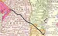
Map of old Chesapeake Beach Railroad from D.C. to Chesapeake Beach

See also
 In Spanish: Chesapeake Beach (Maryland) para niños
