
Cheshire facts for kids
Quick facts for kids
Cheshire
County Palatine of Chester
|
|||||||||||||||||||||||||||||
|---|---|---|---|---|---|---|---|---|---|---|---|---|---|---|---|---|---|---|---|---|---|---|---|---|---|---|---|---|---|
|
|||||||||||||||||||||||||||||
| Motto(s):
Jure Et Dignitate Gladii
("By the right and dignity of the sword") |
|||||||||||||||||||||||||||||
 |
|||||||||||||||||||||||||||||
| Sovereign state | United Kingdom | ||||||||||||||||||||||||||||
| Constituent country | England | ||||||||||||||||||||||||||||
| Region | North West | ||||||||||||||||||||||||||||
| Established | Ancient | ||||||||||||||||||||||||||||
| Time zone | UTC±00:00 (Greenwich Mean Time) | ||||||||||||||||||||||||||||
| • Summer (DST) | UTC+01:00 (British Summer Time) | ||||||||||||||||||||||||||||
| Members of Parliament | List of MPs | ||||||||||||||||||||||||||||
| Police | Cheshire Constabulary | ||||||||||||||||||||||||||||
| Largest town | Warrington | ||||||||||||||||||||||||||||
|
|||||||||||||||||||||||||||||


Cheshire, archaically the County Palatine of Chester, is a historic county in North West England. It is bordered by the counties of Merseyside and Greater Manchester to the north, Derbyshire to the east, Staffordshire and Shropshire to the south, and Wales to the west. Cheshire's county town is Chester, while its largest town by population is Warrington; other major towns include Congleton, Crewe, Ellesmere Port, Knutsford, Macclesfield, Nantwich, Northwich, Runcorn, Widnes, Wilmslow and Winsford.
The county covers 905 square miles (2,344 km2) and has a population of around 1 million. It is mostly rural, with a number of small towns and villages supporting the agricultural and chemical industries; it is known for producing chemicals, Cheshire cheese, salt and silk. It is split into the administrative districts of Cheshire West and Chester, Cheshire East, Halton and Warrington.
Contents
History
Toponymy
Cheshire's name was originally derived from an early name for Chester, and was first recorded as Legeceasterscir in the Anglo-Saxon Chronicle, meaning the shire of the city of legions. Although the name first appears in 980, it is thought that the county was created by Edward the Elder around 920. In the Domesday Book, Chester was recorded as having the name Cestrescir (Chestershire), derived from the name for Chester at the time. A series of changes that occurred as English itself changed, together with some simplifications and elision, resulted in the name Cheshire, as it occurs today.
Because of the historically close links with the land bordering Cheshire to the west, which became modern Wales, there is a history of interaction between Cheshire and North Wales. The Domesday Book records Cheshire as having two complete Hundreds (Atiscross and Exestan) that later became the principal part of Flintshire. Additionally, another large portion of the Duddestan Hundred later became known as Maelor Saesneg when it was transferred to North Wales. For this and other reasons, the Welsh name for Cheshire (Swydd Gaerlleon) is sometimes used within Wales and by Welsh speakers.
Administrative history
.svg)
Pura Wallia (independent Wales) Lands gained by Llywelyn the Great in 1234 Marchia Wallie (lands controlled by Norman Marcher barons)
After the Norman conquest of 1066 by William I, dissent and resistance continued for many years after the invasion. In 1069 local resistance in Cheshire was finally put down using draconian measures as part of the Harrying of the North. The ferocity of the campaign against the English populace was enough to end all future resistance. Examples were made of major landowners such as Earl Edwin of Mercia, their properties confiscated and redistributed amongst Norman barons. William I made Cheshire a county palatine and gave Gerbod the Fleming the new title of Earl of Chester. When Gerbod returned to Normandy in about 1070, the king used his absence to declare the earldom forfeit and gave the title to Hugh d'Avranches (nicknamed Hugh Lupus, or "wolf"). Due to Cheshire's strategic location on Welsh Marches, the Earl had complete autonomous powers to rule on behalf of the king in the county palatine.
Palatine hundreds

Cheshire in the Domesday Book (1086) is recorded as a much larger county than it is today. It included two hundreds, Atiscross and Exestan, that later became part of North Wales. At the time of the Domesday Book, it also included as part of Duddestan Hundred the area of land later known as English Maelor (which used to be a detached part of Flintshire) in Wales. The area between the Mersey and Ribble (referred to in the Domesday Book as "Inter Ripam et Mersam") formed part of the returns for Cheshire. Although this has been interpreted to mean that at that time south Lancashire was part of Cheshire, more exhaustive research indicates that the boundary between Cheshire and what was to become Lancashire remained the River Mersey. With minor variations in spelling across sources, the complete list of hundreds of Cheshire at this time are: Atiscross, Bochelau, Chester, Dudestan, Exestan, Hamestan, Middlewich, Riseton, Roelau, Tunendune, Warmundestrou and Wilaveston.
Palatine feudal baronies
Feudal baronies or baronies by tenure were granted by the Earl as forms of feudal land tenure within the palatinate in a similar way to which the king granted English feudal baronies within England proper. An example is the barony of Halton. One of Hugh d'Avranche's barons has been identified as Robert Nicholls, Baron of Halton and Montebourg.
Lands devolved to Lancashire
In 1182 the land north of the Mersey became administered as part of the new county of Lancashire, thus resolving any uncertainty about the county in which the land "Inter Ripam et Mersam" was. Over the years, the ten hundreds consolidated and changed names to leave just seven—Broxton, Bucklow, Eddisbury, Macclesfield, Nantwich, Northwich and Wirral.
Acquires Welsh-March lands
In 1397 the county had lands in the march of Wales added to its territory, and was promoted to the rank of principality. This was because of the support the men of the county had given to King Richard II, in particular by his standing armed force of about 500 men called the "Cheshire Guard". As a result, the King's title was changed to "King of England and France, Lord of Ireland, and Prince of Chester". No other English county has been honoured in this way, although it lost the distinction on Richard's fall in 1399.
Lands devolved to Greater Manchester and Merseyside metropolitan counties
Through the Local Government Act 1972, which came into effect on 1 April 1974, some areas in the north became part of the metropolitan counties of Greater Manchester and Merseyside. Stockport (previously a county borough), Altrincham, Hyde, Dukinfield and Stalybridge in the north-east became part of Greater Manchester. Much of the Wirral Peninsula in the north-west, including the county boroughs of Birkenhead and Wallasey, joined Merseyside as the Metropolitan Borough of Wirral. At the same time the Tintwistle Rural District was transferred to Derbyshire. The area of south Lancashire not included within either the Merseyside or Greater Manchester counties, including Widnes and the county borough of Warrington, was added to the new non-metropolitan county of Cheshire.
Unitary Authorities created
Halton and Warrington became unitary authorities independent of Cheshire County Council on 1 April 1998, but remain part of Cheshire for ceremonial purposes and also for fire and policing.
Regional Assemblies proposed
A referendum for a further local government reform connected with an elected regional assembly was planned for 2004, but was abandoned.
Abolition of Cheshire County Council
As part of the local government restructuring in April 2009, Cheshire County Council and the Cheshire districts were abolished and replaced by two new unitary authorities, Cheshire East and Cheshire West and Chester. The existing unitary authorities of Halton and Warrington were not affected by the change.
Buildings and structures
- Gallery
-
Nantwich High Street
-
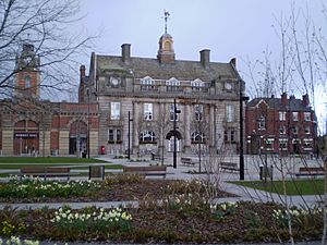
Crewe Town Council
-
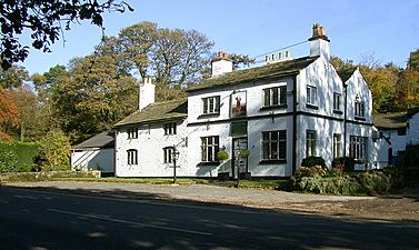
The Wizard Pub, Alderley Edge
-
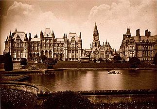
Eaton Hall


.JPG)
.jpg)
Prehistoric burial grounds have been discovered at The Bridestones, near Congleton (Neolithic) and Robin Hood's Tump, near Alpraham (Bronze Age). The remains of Iron Age hill forts are found on sandstone ridges at several locations in Cheshire. Examples include Maiden Castle on Bickerton Hill, Helsby Hillfort and Woodhouse Hillfort at Frodsham. The Roman fortress and walls of Chester, perhaps the earliest building works in Cheshire remaining above ground, are constructed from purple-grey sandstone.
The distinctive local red sandstone has been used for many monumental and ecclesiastical buildings throughout the county: for example, the medieval Beeston Castle, Chester Cathedral and numerous parish churches. Occasional residential and industrial buildings, such as Helsby railway station (1849), are also in this sandstone.
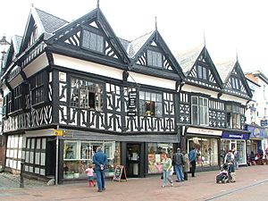
Many surviving buildings from the 15th to 17th centuries are timbered, particularly in the southern part of the county. Notable examples include the moated manor house Little Moreton Hall, dating from around 1450, and many commercial and residential buildings in Chester, Nantwich and surrounding villages.
Early brick buildings include Peover Hall near Macclesfield (1585), Tattenhall Hall (pre-1622), and the Pied Bull Hotel in Chester (17th century). From the 18th century, orange, red or brown brick became the predominant building material used in Cheshire, although earlier buildings are often faced or dressed with stone. Examples from the Victorian period onwards often employ distinctive brick detailing, such as brick patterning and ornate chimney stacks and gables. Notable examples include Arley Hall near Northwich, Willington Hall near Chester (both by Nantwich architect George Latham) and Overleigh Lodge, Chester. From the Victorian era, brick buildings often incorporate timberwork in a mock Tudor style, and this hybrid style has been used in some modern residential developments in the county. Industrial buildings, such as the Macclesfield silk mills (for example, Waters Green New Mill), are also usually in brick.
Physical geography
Cheshire covers a boulder clay plain separating the hills of North Wales and the Peak District of Derbyshire (the area is also known as the Cheshire Gap). This was formed following the retreat of ice age glaciers which left the area dotted with kettle holes, locally referred to as meres. The bedrock of this region is almost entirely Triassic sandstone, outcrops of which have long been quarried, notably at Runcorn, providing the distinctive red stone for Liverpool Cathedral and Chester Cathedral.
The eastern half of the county is Upper Triassic Mercia Mudstone laid down with large salt deposits which were mined for hundreds of years around Winsford. Separating this area from Lower Triassic Sherwood Sandstone to the west is a prominent sandstone ridge known as the Mid Cheshire Ridge. A 55-kilometre (34 mi) footpath, the Sandstone Trail, follows this ridge from Frodsham to Whitchurch passing Delamere Forest, Beeston Castle and earlier Iron Age forts.
The highest point in Cheshire is Shining Tor on the Derbyshire/Cheshire border between Macclesfield and Buxton, at 559 metres (1,834 ft) above sea level. Before county boundary alterations in 1974, the county top was Black Hill (582 m (1,909 ft)) near Crowden in the far east of the historic county on the border with the West Riding of Yorkshire. Black Hill is now the highest point in West Yorkshire.
.JPG)

Demography
Population
Based on the Census of 2001, the overall population of Cheshire East and Cheshire West and Chester is 673,781, of which 51.3% of the population were male and 48.7% were female. Of those aged between 0–14 years, 51.5% were male and 48.4% were female; and of those aged over 75 years, 62.9% were female and 37.1% were male. This increased to 699,735 at the 2011 Census. The population for 2021 is forecast to be 708,000.
In 2001, the population density of Cheshire East and Cheshire West and Chester was 32 people per km2, lower than the North West average of 42 people/km2 and the England and Wales average of 38 people/km2. Ellesmere Port and Neston had a greater urban density than the rest of the county with 92 people/km2.
Population change
| Population totals for Cheshire East and Cheshire West and Chester | |||||||
|---|---|---|---|---|---|---|---|
| Year | Population | Year | Population | Year | Population | ||
| 1801 | 124,570 | 1881 | 303,315 | 1961 | 533,642 | ||
| 1811 | 141,672 | 1891 | 324,494 | 1971 | 605,918 | ||
| 1821 | 167,730 | 1901 | 343,557 | 1981 | 632,630 | ||
| 1831 | 191,965 | 1911 | 364,179 | 1991 | 656,050 | ||
| 1841 | 206,063 | 1921 | 379,157 | 2001 | 673,777 | ||
| 1851 | 224,739 | 1931 | 395,717 | 2011 | 699,735 | ||
| 1861 | 250,931 | 1941 | 431,335 | ||||
| 1871 | 277,123 | 1951 | 471,438 | ||||
| Pre-1974 statistics were gathered from local government areas that now comprise Cheshire Source: Great Britain Historical GIS. |
|||||||
Ethnicity
In 2001, ethnic white groups accounted for 98% (662,794) of the population, and 10,994 (2%) in ethnic groups other than white.
Of the 2% in non-white ethnic groups:
- 3,717 (34%) belonged to mixed ethnic groups
- 3,336 (30%) were Asian or Asian British
- 1,076 (10%) were black or black British
- 1,826 (17%) were of Chinese ethnic groups
- 1,039 (9%) were of other ethnic groups.
Borders
The ceremonial county borders Merseyside, Greater Manchester, Derbyshire, Staffordshire and Shropshire in England along with Flintshire and Wrexham in Wales, arranged by compass directions as shown in the table. below. Cheshire also forms part of the North West England region.
| Neighbouring Authorities to the Ceremonial County |
|---|
 |
Merseyside | Merseyside/Greater Manchester | Greater Manchester | |
| Flintshire | Derbyshire | |||
| Wrexham | Shropshire | Staffordshire |
Religion

In the 2001 Census, 81% of the population (542,413) identified themselves as Christian; 124,677 (19%) did not identify with any religion or did not answer the question; 5,665 (1%) identified themselves as belonging to other major world religions; and 1,033 belonged to other religions.
The boundary of the Church of England Diocese of Chester follows most closely the pre-1974 county boundary of Cheshire, so it includes all of Wirral, Stockport, and the Cheshire panhandle that included Tintwistle Rural District council area. In terms of Roman Catholic church administration, most of Cheshire falls into the Roman Catholic Diocese of Shrewsbury.
Culture, media and sports

Cheshire has one Football League team, Crewe Alexandra who play in League Two. Chester, phoenix club formed in 2010 after an ex-Football League club Chester City was dissolved competes in the National League along with other Cheshire side Macclesfield Town, who played in the Football League from 1997 till 2012. Northwich Victoria are also an ex-Football League team who were founder members of the Football League Division Two in 1892/1893 now represent Cheshire in the Northern Premier League along with Nantwich Town, Warrington Town and Witton Albion.
Warrington Wolves and the Widnes Vikings are the premier Rugby league teams in Cheshire and play in the Super League. There are also numerous junior clubs in the county, including Chester Gladiators. Cheshire County Cricket Club is one of the clubs that make up the Minor counties of English and Welsh cricket. Cheshire also is represented in the highest level basketball league in the UK, the BBL, by Cheshire Phoenix (formerly Cheshire Jets). Each May, Europe's largest motorcycle event, the Thundersprint, is held in Northwich.
The county has also been home to many notable sportsmen and athletes. Due to its proximity to both Manchester and Liverpool, many Premier League footballers have lived in Cheshire, including Dean Ashton, Seth Johnson, Michael Owen and Wayne Rooney. Other local athletes have included cricketer Ian Botham, marathon runner Paula Radcliffe, oarsman Matt Langridge, hurdler Shirley Strong, sailor Ben Ainslie, cyclist Sarah Storey and mountaineer George Mallory, who died in 1924 on Mount Everest. Cheshire has also produced a military hero in Norman Cyril Jones, a World War I flying ace who won the Distinguished Flying Cross.
.jpg)
The county has produced several notable popular musicians, including Gary Barlow (Take That, born and raised in Frodsham), Harry Styles (singer with One Direction, raised in Holmes Chapel), John Mayall (John Mayall & the Bluesbreakers), Ian Astbury (The Cult), Tim Burgess (Charlatans), Ian Curtis (Joy Division) and Hooton Tennis Club. Matthew Healy, lead singer of The 1975, met his three bandmates at Wilmslow High School in Wilmslow. Concert pianist Stephen Hough, singer Thea Gilmore and her producer husband Nigel Stonier also reside in Cheshire.
The county has also been home to several writers, including Hall Caine (1853–1931), popular romantic novelist and playwright; Alan Garner; Victorian novelist Elizabeth Gaskell, whose novel Cranford features her home town of Knutsford; and most famously Lewis Carroll, born and raised in Daresbury, hence the Cheshire Cat (a fictional cat popularised by Carroll in Alice's Adventures in Wonderland and known for its distinctive mischievous grin). Artists from the county include ceramic artist Emma Bossons and sculptor and photographer Andy Goldsworthy. Actors from Cheshire include Tim Curry; Daniel Craig, the 6th James Bond; Dame Wendy Hiller; and Lewis McGibbon, best known for his role in Millions.
Local radio stations in the county include Dee 106.3, Heart and Gold for Chester and West Cheshire, Silk FM for the east of the county, Signal 1 and The Cat 107.9 for the south, Wire FM for Warrington and Wish FM, which covers Widnes. Cheshire is one of the only counties (along with County Durham, Dorset and Rutland) that does not have its own designated BBC Radio station. The majority of the county (south and east) are covered by BBC Radio Stoke, whilst BBC Radio Merseyside tends to cover the west. The BBC directs readers to Stoke and Staffordshire when Cheshire is selected on their website. The BBC covers the west with BBC Radio Merseyside, the north and east with BBC Radio Manchester and the south with BBC Radio Stoke. There were plans to launch BBC Radio Cheshire, but those were shelved in 2007 after a lower than expected BBC licence fee settlement.
Modern county emblem
As part of a 2002 marketing campaign, the plant conservation charity Plantlife chose the cuckooflower as the county flower. Previously, a sheaf of golden wheat was the county emblem, a reference to the Earl of Chester's arms in use from the 12th century.
Settlements
The county is home to some of the most affluent areas of northern England, including Alderley Edge, Wilmslow, Prestbury, Tarporley and Knutsford, named in 2006 as the most expensive place to buy a house in the north of England. The former Cheshire town of Altrincham was in second place. The area is sometimes referred to as The Golden Triangle on account of the area in and around the aforementioned towns and villages.
The cities and towns in Cheshire are:
| Ceremonial county | District | Centre of administration | Other Towns or Cities |
|---|---|---|---|
| Cheshire | Cheshire East (unitary) | Sandbach | Alderley Edge, Alsager, Bollington, Crewe, Congleton, Handforth, Knutsford, Macclesfield, Middlewich, Nantwich, Poynton, Wilmslow |
| Cheshire West and Chester (unitary) | Chester | Ellesmere Port, Frodsham, Malpas, Neston, Northwich, Saltney, Tarporley, Winsford | |
| Halton (unitary) | Widnes | Runcorn | |
| Warrington (unitary) | Warrington | Birchwood, Culcheth, Grappenhall, Lymm |
Some settlements which were historically part of the county now fall under the counties of Derbyshire, Merseyside and Greater Manchester:
| Derbyshire | Crowden, Newtown, Tintwistle, Whaley Bridge (western part), Woodhead |
|---|---|
| Greater Manchester | Altrincham, Bramhall, Bredbury, Cheadle, Cheadle Hulme, Dukinfield, Gatley, Hale, Hazel Grove, Hyde, Marple, Mossley (part), Partington, Romiley, Sale, Stalybridge, Stockport, Woodley, Wythenshawe |
| Merseyside | Bebington, Birkenhead, Brimstage, Bromborough, Eastham, Greasby, Heswall, Hoylake, Irby, Moreton, New Ferry, Port Sunlight, Upton, Wallasey, West Kirby |
Transport
Buses
Bus transport in Cheshire is provided by various operators. The major bus operator in the Cheshire area is Arriva North West. Other operators in Cheshire include Stagecoach Chester & Wirral and Network Warrington.
There are also several operators based outside of Cheshire, who either run services wholly within the area or services which start from outside the area. Companies include Arriva Buses Wales, BakerBus, High Peak, First Greater Manchester, D&G bus and Stagecoach Manchester.
Some services are run under contract to Cheshire West and Chester, Cheshire East, Borough of Halton and Warrington Councils.
Railway

The main railway line through the county is the West Coast Main Line. Trains on the main London to Scotland line call at Crewe (in the south of the county) and Warrington Bank Quay (in the north of the county). Trains stop at Crewe and Runcorn on the Liverpool branch of the WCML; Crewe and Macclesfield are each hourly stops on the two Manchester branches.
The major interchanges are:
- Crewe (the biggest station in Cheshire) for trains to London Euston, Glasgow Central, Edinburgh Waverley, Manchester Piccadilly and Liverpool Lime Street (via the WCML). Trains on other routes travel to Wales, the Midlands (Birmingham, Stoke and Derby) as well as suburban services to Manchester Piccadilly, Chester and Liverpool Lime Street.
- Warrington stations (Central and Bank Quay) for suburban services to Manchester Piccadilly, Chester and Liverpool Lime Street and regional express services to North Wales, London, Scotland, Yorkshire, the East Coast and the East Midlands
- Chester for urban services (via Merseyrail) to Liverpool Central, suburban services to Manchester, Warrington, Wrexham General and rural Cheshire and express services to Llandudno, Holyhead, Birmingham, the West Midlands, London and Cardiff and, from May 2019, to Leeds.
In the east of Cheshire, Macclesfield station is served by Avanti West Coast, CrossCountry and Northern, on the Manchester–London line. Services from Manchester to the south coast frequently stop at Macclesfield.
Road
Cheshire has 3,417 miles (5,499 km) of roads, including 214 miles (344 km) of the M6, M62, M53 and M56 motorways; there are 23 interchanges and four service areas. The M6 motorway at the Thelwall Viaduct carries 140,000 vehicles every 24 hours.
Waterways
-
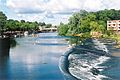
Chester Weir on the River Dee
-
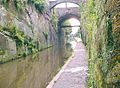
Canal cutting by Chester city walls
-
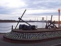
Manchester Ship Canal from Ellesmere Port Dock towards Stanlow


The Cheshire canal system includes several canals originally used to transport the county's industrial products (mostly chemicals). Nowadays they are mainly used for tourist traffic. The Cheshire Ring is formed from the Rochdale, Ashton, Peak Forest, Macclesfield, Trent and Mersey and Bridgewater canals.
The Manchester Ship Canal is a wide, 36-mile (58 km) stretch of water opened in 1894. It consists of the rivers Irwell and Mersey made navigable to Manchester for seagoing ships leaving the Mersey estuary. The canal passes through the north of the county via Runcorn and Warrington.
List of rivers and canals
- Bridgewater Canal
- Macclesfield Canal
- Manchester Ship Canal
- River Bollin
- River Croco
- River Dane
- River Dean
- River Dee / Afon Dyfrdwy
- River Gowy
- River Goyt
- River Mersey
- River Weaver and Weaver Navigation
- River Wheelock
- Shropshire Union Canal and the Llangollen branch
- Trent and Mersey Canal
Economy
Cheshire has a diverse economy with significant sectors including agriculture, automotive, bio-technology, chemical, financial services, food and drink, ICT, and tourism. The county is famous for the production of Cheshire cheese, salt and silk. The county has seen a number of inventions and firsts in its history.
A mainly rural county, Cheshire has a high concentration of villages. Agriculture is generally based on the dairy trade, and cattle are the predominant livestock. Land use given to agriculture has fluctuated somewhat, and in 2005 totalled 1558 km2 over 4,609 holdings. Based on holdings by EC farm type in 2005, 8.51 km2 was allocated to dairy farming, with another 11.78 km2 allocated to cattle and sheep.
The chemical industry in Cheshire was founded in Roman times, with the mining of salt in Middlewich and Northwich. Salt is still mined in the area by British Salt. The salt mining has led to a continued chemical industry around Northwich, with Brunner Mond based in the town. Other chemical companies, including Ineos (formerly ICI), have plants at Runcorn. The Essar Refinery (formerly Shell Stanlow Refinery) is at Ellesmere Port. The oil refinery has operated since 1924 and has a capacity of 12 million tonnes per year.
Crewe was once the centre of the British railway industry, and remains a major railway junction. The Crewe railway works, built in 1840, employed 20,000 people at its peak, although the workforce is now less than 1,000. Crewe is also the home of Bentley cars. Also within Cheshire are manufacturing plants for Jaguar and Vauxhall Motors in Ellesmere Port. The county also has an aircraft industry, with the BAE Systems facility at Woodford Aerodrome, part of BAE System's Military Air Solutions division. The facility designed and constructed Avro Lancaster and Avro Vulcan bombers and the Hawker-Siddeley Nimrod. On the Cheshire border with Flintshire is the Broughton aircraft factory, more recently associated with Airbus.
Tourism in Cheshire from within the UK and overseas continues to perform strongly. Over 8 million nights of accommodation (both UK and overseas) and over 2.8 million visits to Cheshire were recorded during 2003.
At the start of 2003, there were 22,020 VAT-registered enterprises in Cheshire, an increase of 7% since 1998, many in the business services (31.9%) and wholesale/retail (21.7%) sectors. Between 2002 and 2003 the number of businesses grew in four sectors: public administration and other services (6.0%), hotels and restaurants (5.1%), construction (1.7%), and business services (1.0%). The county saw the largest proportional reduction between 2001 and 2002 in employment in the energy and water sector and there was also a significant reduction in the manufacturing sector. The largest growth during this period was in the other services and distribution, hotels and retail sectors.
Cheshire is considered to be an affluent county. However, towns such as Crewe and Winsford have significant deprivation. The county's proximity to the cities of Manchester and Liverpool means counter urbanisation is common. Cheshire West has a fairly large proportion of residents who work in Liverpool and Manchester, while the town of Northwich and area of Cheshire East falls more within Manchester's sphere of influence.
Education
All four local education authorities in Cheshire operate only comprehensive state school systems. When Altrincham, Sale and Bebington were moved from Cheshire to Trafford and Merseyside in 1974, they took some former Cheshire selective schools. There are two universities based in the county, the University of Chester and the Chester campus of The University of Law. The Crewe campus of Manchester Metropolitan University was scheduled to close in 2019.
Images for kids
-

Map of Cheshire in 1577.
-
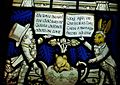
Lewis Carroll memorial window (featuring the Hatter and March Hare)
_Comitatus_(Romanis_Legionibus_et_Colonys_olim_infignis)_vera_et_abfoluta_effigies._Chriftophorus_Saxton_defcripfit._Francifcus_Scatterus_fculpfit_Anno_Dno_1577._RMG_L8558-001.jpg)

See also
 In Spanish: Cheshire para niños
