
Chesterfield facts for kids
Quick facts for kids
Borough of Chesterfield
|
||
|---|---|---|

View of Chesterfield from Old Brampton
|
||
|
||

Shown within Derbyshire
|
||
| Country | United Kingdom | |
| Constituent country | England | |
| Region | East Midlands | |
| County | Derbyshire | |
| Founded | 70–100 AD | |
| Market Charter | 1204 | |
| Borough status | 1204/1594 | |
| Government | ||
| • Type | Non-metropolitan district | |
| Population
(2005 est.)
|
||
| • Total | 104,900 (Ranked 227th) | |
| • Ethnicity | 94.9% White British | |
| Time zone | UTC+0 (Greenwich Mean Time) | |
| Postcode |
S40
|
|
| ISO 3166-2 | GB-DBY | |
| ONS code | 17UD (ONS) E07000034 (GSS) |
|
| Demonym | Cestrefeldian | |
| Website | www.chesterfield.gov.uk | |

Chesterfield is a market town and a borough in Derbyshire, England. It lies 24 miles (39 km) north of Derby and 11 miles (18 km) south of Sheffield, at the confluence of the rivers Rother and Hipper. The borough – which includes the settlements of Whittington, Brimington and Staveley – had a population of 103,800 in 2011. Chesterfield is the second largest town in the ceremonial county of Derbyshire, after the city of Derby.
Archaeological examination of the town has traced its beginnings to the 1st century AD and the construction of a Roman fort, which became redundant and was abandoned once peace was achieved. Later an Anglo-Saxon village grew up on the site. The name Chesterfield derives from the Anglo-Saxon words caester (a Roman fort) and feld (grazing land).
Chesterfield received its market charter in 1204. It still has a moderately sized market of about 250 stalls held three days a week. The town sits on a large coalfield, which formed a major part of the area's economy until the 1980s. Little visual evidence of the mining remains today.
The town's best known landmark is the Church of St Mary and All Saints, popularly known for its "crooked spire", which was originally constructed in the 14th century.
Contents
History
Chesterfield was in the Hundred of Scarsdale. The town received its market charter in 1204 from King John. The charter constituted the town as a free borough, granting the burgesses of Chesterfield the same privileges as those of Nottingham and Derby. In 1266, it was the site of the Battle of Chesterfield, in which a band of rebel barons were defeated by a royalist army.
Elizabeth I granted a charter of incorporation in 1594 (or 1598), creating a corporation consisting of a mayor, six aldermen, six brethren, and twelve capital burgesses. This remained the governing charter until the borough was reformed under the Municipal Corporations Act 1835. The borough originally consisted only of the township of Chesterfield, but it was extended in 1892 to parts of some surrounding townships. In 1920 there was a major extension when the borough absorbed New Whittington and Newbold urban district. Chesterfield's current boundaries date from 1 April 1974, when under the Local Government Act 1972, the Borough of Chesterfield was formed by an amalgamation of the municipal borough with the urban district of Staveley and with the parish of Brimington from Chesterfield Rural District.

Chesterfield benefited greatly from the building of the Chesterfield Line – part of the Derby to Leeds railway (North Midland Line), which was begun in 1837 by George Stephenson. During the work, a sizeable seam of coal was discovered during the construction of the Clay Cross Tunnel. This and the local ironstone were promptly exploited by Stephenson, who set up a company in Clay Cross to trade in the minerals.
During his time in Chesterfield, Stephenson lived at Tapton House, and remained there until his death in 1848. He is interred in Trinity Church. In 2006, a statue of Stephenson was erected outside Chesterfield railway station.
Geography
Chesterfield is located on the confluence and valleys of the River Rother and River Hipper at the Nottinghamshire, Derbyshire and Yorkshire Coalfield. The town also lies in the eastern foothills of the Pennines, and is also known as a gateway to the Peak District National Park or "The Gateway to the Peak" lying to the west of the town.
Transport
Roads
The town is located on the A61, 6 miles (9.7 km) from the M1.
Junction 29 of the M1 motorway at Heath links Chesterfield to the motorway network to the south, via the A617 dual-carriageway. Junction 29a at Markham Vale, Duckmanton opened at the end of June 2008, but the signs do not signpost Chesterfield. The town has links to the M1 at Junction 30 and to the north via the A619. Other major roads include the A61 Sheffield Road (north)/Derby Road (south) (with a dual carriageway beginning in the town centre and continuing onto Sheffield) and the A619 (a major inroad to the Peak District, eventually joining the A6 near Bakewell) and the A632 to Matlock.
Buses, taxis and coaches

Stagecoach in Chesterfield are the predominant operator of buses in Chesterfield; other operators include Henry Hulleys, Trent Barton and TM Travel. Buses stop in several areas around the town centre rather than at a central bus station. The Stagecoach depot at Stonegravels is notable for its size and many vehicles stored there are not in regular use. Formerly it was the Chesterfield Corporation bus depot.
A new Chesterfield Coach Station opened in 2005, It was built on the site of the old bus station, It is owned by Stagecoach and is served by Stagecoach Express and National Express coach services.
The main taxi ranks are located on Elder Way and Knifesmithgate as well as outside the railway station. Chesterfield's taxis can be easily recognised to hail as they are black in colour with distinctive white bonnets and tailgates.
Railways
Chesterfield railway station is located on the Midland Main Line. Three train companies provide local and national services:
- East Midlands Trains to St Pancras International, Sheffield, Leicester, Leeds, Liverpool, Manchester, Nottingham and Norwich,
- CrossCountry to Aberdeen, Birmingham, Bournemouth, Bristol, Edinburgh, Glasgow, Newcastle upon Tyne, Penzance, Plymouth and York, and
- Northern to Barnsley, Leeds, Nottingham, Wakefield and Sheffield
Chesterfield previously had two other rail stations
- Chesterfield Market Place railway station was closed in 1951 because of the prohibitive cost of maintaining Bolsover Tunnel and the nearby Doe Lea Viaduct, both of which were affected by mining subsidence. It had served as the terminus of the Chesterfield to Lincoln line, built in 1897 by the Lancashire, Derbyshire and East Coast Railway (LD&ECR). None of the original buildings remains, the site of the former station being now owned by the Post Office.
- Chesterfield Central Station closed in 1963, in conjunction with the general wind down of passenger train activity on the Great Central Railway (GCR). Chesterfield's inner relief road, part of the A61, now runs along some of the disused trackbed. The station was demolished in 1973 to make way for the road.
These railways all crossed each other at Horns Bridge, the Midland Main Line passed over the GCR loop into Chesterfield, and the LD&ECR passed over both on a 700 feet (210 m) long viaduct. Horns Bridge has been substantially redeveloped since the latter two railways closed and Horns Bridge Roundabout, where the A61 Derby Road and A617 Lordsmill Street meet, now occupies the site. The viaduct was demolished in the 1970s.
In addition to railways, Chesterfield had a tramway system, which was built in 1882 and closed in 1927.
Air
The nearest licensed airfield is Netherthorpe Aerodrome near Worksop in Nottinghamshire, but it is less than 600m of grass. When travelling by air, passengers usually do so via East Midlands, Leeds Bradford, Doncaster Sheffield Robin Hood and Manchester airports. These are all within two hours travel time by road.
Canal
The Chesterfield Canal linked the town to the national network of waterways, and was the most important trade route through the 19th century. Overtaken by rail and then road for freight transport it fell into disuse, but has been partially restored since the mid-20th century for leisure use. However, the section through Chesterfield remains isolated from the rest of the waterway network.
Religious sites


Chesterfield is perhaps best known for the "crooked spire" of its Church of Saint Mary and All Saints and is why the local football team is known as The Spireites.
The spire is both twisted and leaning, twisting 45 degrees and leaning 9 feet 6 inches (2.90 m) from its true centre. Folklore recounts that a Bolsover blacksmith mis-shod the Devil, who leapt over the spire in pain, knocking it out of shape. In reality the leaning characteristic has been attributed to various causes, including the absence of skilled craftsmen (the Black Death having been gone only twelve years prior to the spire's completion), the use of unseasoned timber, and insufficient cross-bracing. According to the curators of Chesterfield Museum,.
Also within Chesterfield is the Annunciation Church. It was founded by the Jesuits in 1854 and was designed by Joseph Hansom.
Sports and leisure
Chesterfield is home to the Football League One club Chesterfield F.C. who formerly played at the Recreation Ground (usually referred to as Saltergate). Chesterfield FC are known as the Spireites, after the Crooked Spire in the town. In 2005 plans were announced to build a new stadium on the old Dema Glass site north of the town in Whittington Moor. Construction of the new stadium, named the 'B2net Stadium' began in summer 2009 and was completed for the start of the 2010/2011 season. The B2net stadium became the Proact stadium for the 2012–13 season due to the restructuring of the sponsoring company. The team's most notable achievement of recent years occurred in April 1997, when they reached the semi-final of the FA Cup, losing to Middlesbrough in a replay following a 3–3 draw at Old Trafford. It turned out to be one of the most controversial in recent history with Chesterfield having a goal not given when referee David Elleray decided the ball had not crossed the goal line from a Jonathan Howard shot, a decision which was later proved incorrect by video replays. Had the goal stood the club would have progressed to the final of the FA Cup for the first time in its history—a feat which no club in the third tier of the league has achieved. The team has a fierce rivalry with neighbouring town Mansfield. In 2006 Chesterfield FC beat Premiership heavyweights Manchester City and West Ham to move into the last 16 of the League Cup where they were narrowly beaten on penalties by Charlton Athletic. Despite their League Cup exploits, Chesterfield were relegated on the penultimate game of the season
Chesterfield Ladies FC have women's and girls' teams and are based at Queens Park Annexe; they play in the Sheffield & Hallamshire Girls County League.
Also Chesterfield has a competitive athletic team which competes regularly all over England. Chesterfield & District Athletic Club.

Chesterfield Swimming Club, the largest competitive swimming club in North Derbyshire, is based at the Queen's Park Sports Centre on Boythorpe Road. In October 2011 the club began delivering the programme for Derventio eXcel (Performance Swim Squad for Derbyshire) for the North East of the county. In 2012, Chesterfield SC took part in the Arena National Swimming League and achieved promotion to the top division at the first attempt. Further success led to increased membership.
Queen's Park also plays host to Chesterfield Cricket Club and is an outground of Derbyshire County Cricket Club
Chesterfield also has its own amateur Sunday football league that plays host to over 100 teams on a Sunday morning. The Chesterfield and District Sunday Football League consists of nine divisions and three cup competitions.
Chesterfield Spires RLFC are a Rugby League club formed in the town in 2003 and currently play in the RL Merit League
A speedway training track operated at Glasshouse Farm in the early 1950s.
Chesterfield also has a mildly successful Men's Hockey Team which typically competes in the Midland's Premier Hockey League. The side has typically been midtable or battled against relegation until its greatest success when it recruited Australian import striker Adam Clifford from Tasmania. During his two seasons Clifford scored over 50 goals and Chesterfield narrowly lost the league in the final weeks by a single point.
Chesterfield Rugby Union Football Club was initially formed in 1919 and played their first game in 1920. They field three men's senior squads, a senior ladies squad and numerous junior teams—the senior squads can be found training on Tuesday and Thursday nights from 7 pm. They relocated to a new purpose built ground on the outskirts of the town at 2012 Dunston Road from the former Stonegravels site, the 2013/14 season was the first season at the new ground. The facilities include three rugby pitches (one of which is floodlit), numerous changing rooms and a large open plan bar area which serves 'Panther's Pride' ale.
There has been success over the 2013/14 season with the 1stXV winning the championship (Midlands North 4) and being promoted to the Midlands North 3 for the first time in 25 years. The 2ndXV won the Notts, Lincs and Derbys Cup competition to the delight of the large supporting crowd. Notable contributions by Derek Sherlock, Gerraint Davies, John Jefferson and Mark Blair along with a burgeoning supporting crowd have helped secure their position in the league. The recent success was locally publicised on the radio and in print form which has sparked extra interest in the club and the game with a strong turnout of new and existing players.
The club has been a nurturing ground for players who have made the grade to professional level to such clubs as Northampton Saints and London Wasps.
Queen's Park
Queen's Park is located just outside the town centre, recently benefited from a multimillion-pound programme of investment, allowing it to host county cricket once again. Alderman T P Wood, Mayor of Chesterfield in 1886 proposed that local land should be acquired by the Local Board for the creation of a public park to mark the Golden Jubilee of Queen Victoria in 1887, and officially opened in 1893. The park includes a Cricket field, pavilion, lake, conservatory, bandstand, and miniature railway. A further 13 acres (5.3 ha) of land south of the park separated by a road was acquired as a memorial to Queen Victoria in 1901, and was laid out as a recreation ground known as Queen's Park Annex.
Queen's Park Sports Centre
Queens Park Sports Centre was constructed in the mid- and late-20th century within Queen's Park, adjacent to its western boundary, which included a swimming pool, gym, several indoor courts (for a variety of sports) and several more outdoor tennis courts, before closing in December 2015.
A new £11.2 million building for Queen's Park Sports Centre was opened in January 2016, on the Queen's Park Annex south of Queen's Park. The facility includes: an eight-lane swimming pool, learner pool, gym, eight-court sports hall, squash courts, training rooms, exercise class studio, climbing wall, and café.
Healthy Living Centre, Staveley
The town also has a Healthy Living Centre within the Borough at Staveley. The centre, which opened in Spring 2008, has a 25 m (82 ft) swimming pool with a movable platform, an 11 m (36 ft) climbing wall, leisure facilities including an indoor children's soft play area, crèche facilities, a fitness suite, health spa and dance studios.
Skate park
A 565 m2 (6,080 sq ft) skate park was built by Freestyle and opened in June 2009, on land behind Ravenside Retail Park and B&Q near to Horns Bridge.
Nearby places
 |
Glossop, Hathersage, Hope Valley | Dronfield, Sheffield | Brimington, Staveley, Clowne, Creswell, Whitwell, Worksop, Mosborough, Eckington, Killamarsh | |
| Bakewell, Buxton | Bolsover, Shirebrook, Langwith | |||
| Matlock, Wirksworth | Clay Cross, Alfreton, Ripley, Derby | Sutton in Ashfield, Mansfield, Nottingham |
Twinnings
Images for kids
-
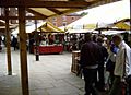
Part of Chesterfield's market
-
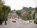
A street in Chesterfield
-
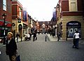
Vicar Lane after it was re-developed
-
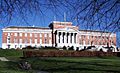
Chesterfield Town Hall (1935-38) by A J Hope.


See also
 In Spanish: Chesterfield (desambiguación) para niños
