Chestnut Hill, Massachusetts facts for kids
Quick facts for kids
Chestnut Hill
|
|
|---|---|
|
Village
|
|

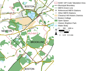
Map of Chestnut Hill
|
|
| Country | United States |
| State | Massachusetts |
| County | Norfolk County, Suffolk County, and Middlesex County |
| ZIP Code |
02467
|
Chestnut Hill is an affluent New England village located six miles (9.7 km) west of downtown Boston, Massachusetts, United States. Like all Massachusetts villages, Chestnut Hill is located within one or more incorporated municipal entities. It is located partially in Brookline in Norfolk County; partially in the Brighton neighborhood of the city of Boston in Suffolk County, and partially in the city of Newton in Middlesex County. Chestnut Hill's borders are defined by the 02467 ZIP Code. The name refers to several small hills that overlook the 135-acre (546,000 m2) Chestnut Hill Reservoir rather than one particular hill. Chestnut Hill is best known as the home of Boston College and as part of the Boston Marathon route.
History
While most of Chestnut Hill remained farmland well into the early twentieth century, the area around the reservoir was developed, in 1870, by landscape architect Frederick Law Olmsted, designer of Central Park in New York City and of the Emerald Necklace in Boston and Brookline.
Because of the significance of its landscape and architecture, the National Register of Historic Places, in 1986, designated parts of Chestnut Hill as historic districts. Examples of Colonial, Italianate, Shingle, Tudor Revival, and Victorian architectural styles are evident in the village's country estates and mansions. The Boston College campus is itself an early example of Collegiate Gothic architecture.
Parkland
Hammond Pond Reservation, an extensive forest preserve and protected wetlands, goes through Chestnut Hill and Newton. Kennard Park and Conservation Area This is a post-agricultural forest grown up on 19th century farmland. The mixed and conifer woodlands reveal colonial stone walls, a red maple swamp with century-old trees, and a sensitive fern marsh.)
Transportation
Chestnut Hill is served by three branches of the Green Line of the MBTA, Boston's light rail system. Stations include:
- B branch: Chestnut Hill Avenue, South Street, Boston College
- C branch: Cleveland Circle
- D branch: Reservoir, Chestnut Hill
The area is also served by various MBTA buses.
Registered historic districts
- Boston College Main Campus Historic District—140 Commonwealth Ave. (in Newton)
- Chestnut Hill Historic District—roughly bounded by Middlesex Rd., Reservoir Ln., Denny Rd., Boylston St. and Dunster Rd. (added November 17, 1985) (mostly in Brookline, but includes a few properties that spill into Newton)
- Chestnut Hill Reservoir Historic District—within Boston city limits
- Old Chestnut Hill Historic District—along Hammond St. and Chestnut Hill Rd. roughly bounded by Beacon St. and Essex Rd., and Suffolk Rd. (added October 4, 1986), within Newton city limits
Education
The village is served by the Brookline Public Schools, Newton Public Schools, and Boston Public Schools, depending on the city or town in which a particular home is located. There are also a number of private schools including Mount Alvernia Academy (Catholic, K–6), Brimmer and May School (non-denominational, K–12) and The Chestnut Hill School.
Chestnut Hill is home to Boston College and Pine Manor College.

