
Chitral District facts for kids
Quick facts for kids
Chitral
|
|
|---|---|

Map of Khyber Pakhtunkhwa with Chitral District highlighted
|
|
| Country | |
| Province | Khyber Pakhtunkhwa |
| Capital | Chitral |
| Established | 1970 |
| Area | |
| • Total | 14,850 km2 (5,730 sq mi) |
| Population
(2004)
|
|
| • Total | 378,000 |
| • Density | 25/km2 (60/sq mi) |
| Time zone | UTC+5 (PST) |
| Number of Tehsils | 6 |
| Website | http://www.nwfp.gov.pk/ |
Chitral (Urdu: ضلع چترال) is a district in the Khyber Pakhtunkhwa province of Pakistan that contains the town of Chitral. It has an area of 14,850 km². It had about 318,689 people at the 1998 Census, which grew to about 378,000 people by 2004. It has one of the highest mountains of the world, Tirich Mir. It is the largest district in Khyber Pakhtunkhwa, covering an area of 14,850 sq. kilometres.
Location
Chitral District is the most northerly district in the Khyber Pakhtunkhwa province, to the west and north is Afghanistan - in the north the Wakhan Corridor, a narrow strip claimed by Pakistan, it separates Pakistan from Central Asian Union. To the east of Chitral are the federally controlled Northern Areas of Pakistan-administered Kashmir and to the south are the Pakistani internal districts of Upper Dir and Swat. Chitral can be accessed by air via the Chitral Airport which is approximately 3 km from the town. Regular flights from Peshawar and Islamabad are run by the PIA.
Terrain
The terrain of Chitral is quite mountainous, part of the Pamir Mountains are situated here. Tirich Mir which at 25,289 feet (7,708 metres) is the highest peak of the Hindu Kush, rises in the north of the district.
Chitral is connected to the rest of Pakistan by only two road routes, the Lowari Pass (el. 10,230 ft.) from Dir and Shandur Top (el. 12,200 ft.) from Gilgit. Both routes are closed in winter. The Lowari Tunnel is being constructed under the Lowari Pass and is opened two times a week when Lowari Top is closed due to snowfall.
It was reported in 2004 that Afghanistan had agreed to allow access from Pakistan to Chitral though Afghan territory and the Kunar Valley, by passing Lowari Pass.
Two other passes give access on foot to Chitral, the Broghol Pass and the Dorah Pass, both from Afghanistan. Both are closed in winter.
Population
The general population is mainly of the Kho people, who speak the Khowar language (or Chitrali), which is also spoken in parts of Yasin, Gilgit and Swat. Chitral is also home to the Kalash tribe who live in three remote valleys southwest of Chitral town.
The Norwegian linguist Georg Morgenstierne wrote that Chitral is the area of the greatest linguistic diversity in the world. Although Khowar is the predominant language of Chitral, more than ten other languages are spoken here. These include Kalasha-mun, Erina, Savi Palula, Dameli, Gawar-Bati, Nuristani, Yidgha, Burushaski, Wakhi, Kyrgyz, Persian and Pashto. Since many of these languages have no written form, letters are usually written in Urdu or Persian
History
Until 1969, Chitral was a princely state, within the Malakand Agency. In 1970 Chitral was absorbed into Pakistan as the new Chitral District, until 2000 within Malakand Division.
Administration
The district of Chitral is divided into six tehsils
- Chitral
- Drosh Tehsil
- Lotkuh Tehsil
- Mastuj Tehsil
- Mulkoh Tehsil
- Turkoh Tehsil
The district is represented in the provincial assembly by two elected MPAs who represent the following constituencies:
- PF-89 (Chitral-1)
- PF-90 (Chitral-2)
Images for kids
-
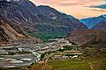
Shandur, Chitral
-
thumbnail
-
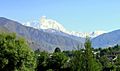
Tirich Mir mount chitral
-
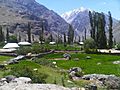
Chitral Ayun
_20.jpg)


