
Circle MRT Line facts for kids
Quick facts for kids Circle MRT Line地铁环线 |
|
|---|---|

The Circle Line is coloured orange on system maps.
|
|
| Overview | |
| Status | Operational |
| Owner | Land Transport Authority |
| Termini | Dhoby Ghaut HarbourFront Marina Bay |
| Stations | 33 (excluding Bukit Brown) |
| Service | |
| Type | Rapid transit |
| System | Mass Rapid Transit (Singapore) |
| Services | 3 |
| Operator(s) | SMRT Trains |
| Rolling stock | C830 C830C |
| History | |
| Opened | 28 May 2009 (Stage 3) 17 April 2010 (Stages 1 & 2) 8 October 2011 (Stages 4 & 5 except Bukit Brown) 14 January 2012 (Marina Bay Extension) 2025 (Stage 6) |
| Technical | |
| Line length | 35.7 km (22.2 mi) |
| Character | Fully underground |
| Track gauge | 1,435 mm (4 ft 8 1⁄2 in) |
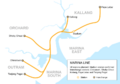
The 35.7-kilometre Circle MRT Line (CCL) is Singapore's fourth Mass Rapid Transit line, and the first medium capacity line. This underground line is 35.7 kilometres (22.2 mi) long with 30 stations (excluding Bukit Brown) and is fully automatically operated. As the name implies, the line is an orbital line linking all radial lines leading to the city, and also covering many parts of the Central Area. It will also connect to Marina South via a spur line branching off from Promenade and ending at Marina Bay. Circle Line is not a full circle, and the Stage 6 will only merge the section from Marina Bay to HarbourFront.
The first part opened to the public from Bartley to Marymount on May 28, 2009. When finished, the line will connect all MRT lines, and will allow passengers to bypass the downtown area, so that the City Hall and Raffles Place interchange stations will be less crowded. The second part opened to the public from Bartley to Dhoby Ghaut on April 17, 2010 while the remaining parts will be opened in October 8, 2011. Circle Line Extension (CCLe) had been in operation since 14 January 2012.
Overview
As the name implies, the line is an orbital circle route linking all radial routes leading to the city. Plans for the Circle Line were laid out in the 1980s, when the then Minister for Communications and Information, Dr Yeo Ning Hong stated that such a system "would be feasible when the population reaches four million."
Construction started in April 2002, and the Circle Line was supposed to be opened in stages from 2006 to 2010, with an estimated cost of S$6.7 billion, but the Nicoll Highway collapse caused the opening of the first stage to be delayed to 28 May 2009 (the Stage 1 of which it is not affected by Nicoll Highway collapse), and the line fully opened on 8 October 2011, at an escalated cost of nearly $10 billion.
Stations
The main route goes between Dhoby Ghaut and HarbourFront, with a branch line between Marina Bay and Stadium. Its train frequency is 5 minutes during off-peak, and 2.5 minutes during peak hours, the branch line is being extended to HarbourFront.
| Station Number | Station Name | Images | Interchange/Notes |
| Dhoby Ghaut |  |
Interchange with the North South Line and the North East Line | |
| CC2 | Bras Basah |  |
|
| CC3 | Esplanade |  |
Out-of-system transfer to the North South Line and the East West Line |
| Promenade |  |
Interchange with the Downtown Line | |
| CC5 | Nicoll Highway |  |
|
| CC6 | Stadium |  |
Marina Bay shuttle terminus during off-peak hours |
| CC7 | Mountbatten | ||
| CC8 | Dakota | ||
| Paya Lebar |  |
Interchange with the East West Line | |
| MacPherson |  |
Interchange with the Downtown Line | |
| CC11 | Tai Seng |  |
|
| CC12 | Bartley |  |
|
| Serangoon |  |
Interchange with the North East Line | |
| CC14 | Lorong Chuan |  |
|
| Bishan |  |
Interchange with the North South Line | |
| CC16 | Marymount | ||
| Caldecott | Interchange with the Thomson-East Coast Line | ||
| CC18 | Bukit Brown |  |
Closed until further notice; Reserved station; Not in operation |
| Botanic Gardens | Interchange with the Downtown Line | ||
| CC20 | Farrer Road | ||
| CC21 | Holland Village | ||
| Buona Vista |  |
Interchange with the East West Line | |
| CC23 | one-north |  |
|
| CC24 | Kent Ridge |  |
|
| CC25 | Haw Par Villa | ||
| CC26 | Pasir Panjang | ||
| CC27 | Labrador Park | ||
| CC28 | Telok Blangah | ||
| HarbourFront | .jpg) |
Interchange with the North East Line | |
| Stage 6 (Under planning) (Completion by 2025) | |||
|---|---|---|---|
| CC30 | Keppel | ||
| CC31 | Cantonment | ||
| CC32 | Prince Edward | ||
| Circle Line Extension | |||
| Bayfront | _-_Platform_B.jpg) |
Cross-Platform Interchange with the Downtown Line | |
| Marina Bay |  |
Interchange with the North South Line and the Thomson-East Coast Line (2021)
Out of system transfer to DT17 Downtown |
|
Images for kids
-
The Marina MRT Line as announced in 1997; 18 stations were planned for the line.
-
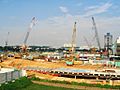
The construction of Bishan station.


