
Clarendon, South Australia facts for kids
Quick facts for kids ClarendonSouth Australia |
|||||||||||||||
|---|---|---|---|---|---|---|---|---|---|---|---|---|---|---|---|

Clarendon Police Station and Court House (built 1868)
|
|||||||||||||||

Clarendon
Location in South Australia
|
|||||||||||||||
| Population | 618 (2016 census) | ||||||||||||||
| Established | 1840 | ||||||||||||||
| Postcode(s) | 5157 | ||||||||||||||
| Elevation | 188 m (617 ft) | ||||||||||||||
| Location | 35.5 km (22 mi) from Adelaide | ||||||||||||||
| LGA(s) | City of Onkaparinga | ||||||||||||||
| Region | Southern Adelaide | ||||||||||||||
| County | Adelaide | ||||||||||||||
| State electorate(s) | Heysen | ||||||||||||||
| Federal Division(s) | Mayo | ||||||||||||||
|
|||||||||||||||
Clarendon is a small town in the Adelaide Hills, about 25–30 kilometres (16–19 mi) south of the Adelaide city centre and now regarded as an outer suburb of Adelaide. It lies within the City of Onkaparinga council area. The Clarendon Weir is located in the town area, on the Onkaparinga River.
History
On 21 October 1840, Richard Blundell was granted the title to Section 801 Hundred of Noarlunga. This was subsequently subdivided and by 1866 the town was described as a regional centre ‘in the midst of a fine agricultural district, where wheat, peas, and potatoes are largely grown’.
Early trade was built around local vineyards and around proximity to the Onkaparinga River. From 1894 to 1896 the Clarendon Weir was constructed, enhancing the local economy.
In the last 20 years a restoration programme has seen the town's heritage buildings restored.
- Old Reynella - European History and Heritage [1]
Images for kids
-
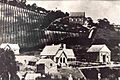
Vineyards and Police Station, date unknown
-
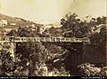
Clarendon bridge around 1869


