Clay County, Texas facts for kids
Quick facts for kids
Clay County
|
|
|---|---|

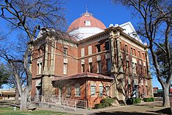
Clay County Courthouse in Henrietta
|
|

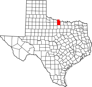
Location within the U.S. state of Texas
|
|
 Texas's location within the U.S. |
|
| Country | |
| State | |
| Founded | 1860 |
| Named for | Henry Clay |
| Seat | Henrietta |
| Largest city | Henrietta |
| Area | |
| • Total | 1,117 sq mi (2,890 km2) |
| • Land | 1,089 sq mi (2,820 km2) |
| • Water | 28 sq mi (70 km2) 2.5% |
| Population
(2020)
|
|
| • Total | 10,218 |
| • Density | 9.148/sq mi (3.5320/km2) |
| Time zone | UTC−6 (Central) |
| • Summer (DST) | UTC−5 (CDT) |
| Congressional district | 13th |
Clay County is a county located in the U.S. state of Texas. As of the 2020 census, its population was 10,218. The county seat is Henrietta. The county was founded in 1857 and later organized in 1860. It is named in honor of Henry Clay, famous American statesman, Kentucky Senator and United States Secretary of State.
Clay County is part of the Wichita Falls, Metropolitan Statistical Area in North Texas.
Several railroads once served Clay County, including the Wichita Falls Railway, one of the properties of Joseph A. Kemp and his brother-in-law Frank Kell, along with twenty-nine other stockholders. The Wichita Falls Railway linked Henrietta with Wichita Falls. Built in 1894–1895, it was sold in 1911 to the Missouri-Kansas-Texas Railroad, also known as the Katy. The original eighteen miles of track was abandoned in 1970.
The Wichita Falls rancher, oilman, and philanthropist Joseph Sterling Bridwell owned a ranch in Clay County, among his multiple holdings.
Clay County is represented in the Texas House of Representatives by the Republican James Frank, a businessman from Wichita Falls.
Contents
Geography
According to the U.S. Census Bureau, the county has a total area of 1,117 square miles (2,890 km2), of which 1,089 square miles (2,820 km2) is land and 28 square miles (73 km2) (2.5%) is water.
Lake Arrowhead State Park, a 524-acre (212 ha) development on Lake Arrowhead in Clay County, encompasses 14,390-acre (5,820 ha) acres. The lakeshore extends 106 miles; the park offers bicycling, birding, boating, camping, canoeing, fishing, hiking, horseback riding, nature study, picnicking, swimming, and wildlife observation.
Adjacent counties
- Jefferson County, Oklahoma (north)
- Montague County (east)
- Jack County (south)
- Wichita County (west)
- Archer County (west)
- Cotton County, Oklahoma (northwest)
Demographics
| Historical population | |||
|---|---|---|---|
| Census | Pop. | %± | |
| 1860 | 109 | — | |
| 1880 | 5,045 | — | |
| 1890 | 7,503 | 48.7% | |
| 1900 | 9,231 | 23.0% | |
| 1910 | 17,043 | 84.6% | |
| 1920 | 16,864 | −1.1% | |
| 1930 | 14,545 | −13.8% | |
| 1940 | 12,524 | −13.9% | |
| 1950 | 9,896 | −21.0% | |
| 1960 | 8,351 | −15.6% | |
| 1970 | 8,079 | −3.3% | |
| 1980 | 9,582 | 18.6% | |
| 1990 | 10,024 | 4.6% | |
| 2000 | 11,006 | 9.8% | |
| 2010 | 10,752 | −2.3% | |
| 2020 | 10,218 | −5.0% | |
| U.S. Decennial Census 1850–2010 2010 2020 |
|||
2020 census
| Race / Ethnicity | Pop 2010 | Pop 2020 | % 2010 | % 2020 |
|---|---|---|---|---|
| White alone (NH) | 9,941 | 8,941 | 92.46% | 87.50% |
| Black or African American alone (NH) | 53 | 35 | 0.49% | 0.34% |
| Native American or Alaska Native alone (NH) | 115 | 78 | 1.07% | 0.76% |
| Asian alone (NH) | 28 | 50 | 0.26% | 0.49% |
| Pacific Islander alone (NH) | 1 | 0 | 0.01% | 0.00% |
| Some Other Race alone (NH) | 5 | 31 | 0.05% | 0.30% |
| Mixed Race/Multi-Racial (NH) | 142 | 442 | 1.32% | 4.33% |
| Hispanic or Latino (any race) | 467 | 641 | 4.34% | 6.27% |
| Total | 10,752 | 10,218 | 100.00% | 100.00% |
Note: the US Census treats Hispanic/Latino as an ethnic category. This table excludes Latinos from the racial categories and assigns them to a separate category. Hispanics/Latinos can be of any race.
Transportation
Major highways
Farm to Market Roads
Communities
Cities
Town
- Windthorst (mostly in Archer County)
Unincorporated communities
See also
 In Spanish: Condado de Clay (Texas) para niños


