
Clayton, New Mexico facts for kids
Quick facts for kids
Clayton, New Mexico
|
|
|---|---|

Main Street (2008)
|
|

Location of Clayton within Union County and New Mexico
|
|
| Country | United States |
| State | New Mexico |
| County | Union |
| Area | |
| • Total | 7.79 sq mi (20.19 km2) |
| • Land | 7.78 sq mi (20.16 km2) |
| • Water | 0.01 sq mi (0.03 km2) |
| Elevation | 5,056 ft (1,541 m) |
| Population
(2010)
|
|
| • Total | 2,980 |
| • Estimate
(2019)
|
2,681 |
| • Density | 344.47/sq mi (133.00/km2) |
| Time zone | UTC−7 (Mountain (MST)) |
| • Summer (DST) | UTC−6 (MDT) |
| ZIP code |
88415
|
| Area code | 575 |
| FIPS code | 35-15720 |
| GNIS ID | 0905193 |
| Website | claytonnm.org |
Clayton is a town and county seat of Union County, New Mexico, United States. As of the 2010 census, the city population was 2,980.
History
.jpg)
The Cimarron Cutoff of the Santa Fe Trail brought some of the first Americans through the Clayton region. The Santa Fe Trail was first established in 1821 after Spanish rule was evicted from Mexico which opened up trade between Santa Fe and the United States. William Becknell, also known as the Father of the Santa Fe Trail, became the first person to utilize the Santa Fe Trail as a trade route between the state of Missouri and Santa Fe. He established the Cimarron Cutoff, also known as the Cimarron Route, as a faster route between countries as the Cimarron Route shortened the Trail by more than 100 miles. The Cimarron Cutoff went straight through the Clayton region where travelers used the Rabbit Ear Mountain as a guiding landmark. Eventually travelers along the trail began to appreciate the rich soil around Clayton and the rolling green hills which where perfect for raising livestock. Cattle ranchers and sheepherders established ranches in the area, though they were large and far apart. That changed when the railroad came to the area and Stephen Dorsey, a nearby rancher, received the rights to the area where the railroad ran. He soon laid out a town site.
Clayton is named for a son of U.S. Senator Stephen W. Dorsey, an Arkansas Republican, originally from Ohio, who served during Reconstruction. The town was established in 1887. The town was a livestock shipping center for herds from the Pecos River and the Texas Panhandle.
Geography
According to the United States Census Bureau, the town has a total area of 4.7 square miles (12 km2), all land. Clayton has an elevation of approximately 5050 ft. above sea level. It is located aout 130 miles northeast of Amarillo Texas. Clayton is considered to be in the Plains region of New Mexico. This region stretches to the Sangre de Cristos Mountains down to the Guadalupe Mountains.Clayton is located in the northeast corner of New Mexico, 10 miles from the border of Texas and 11 miles from the border of the Oklahoma panhandle. Clayton is also located near two parks, Clayton Lake State Park, and Capulin Volcano National Monument. A Carbon Dioxide Field called Bravo Dome can be found near Clayton and stretches nearly 1 million acres.
Also in Clayton there are thought to be underground tunnels. These tunnels were believed to have connected to every building in Clayton, but most have been sealed off due to safety precautions. The locals believe these tunnels were created for a number of reasons, but they are not sure as to what the specific reason for their creation was. Some believe it was for the alcohol prohibition during the 1920's, while others believe that they were created for a safe place during serious storms, such as the one in 1908 that completely destroyed the Court House, and yet others believe that they were only made for maintenance. The mystery of these tunnels leaves a certain charm to them, and sparks interest in locals.
Climate
| Monthly Normal and Record High and Low Temperatures | ||||||||||||
| Month | Jan | Feb | Mar | Apr | May | Jun | Jul | Aug | Sep | Oct | Nov | Dec |
|---|---|---|---|---|---|---|---|---|---|---|---|---|
| Rec High °F | 80 | 81 | 86 | 91 | 99 | 104 | 102 | 102 | 99 | 93 | 85 | 83 |
| Norm High °F | 47.4 | 51.5 | 58.2 | 66.1 | 74.2 | 83.9 | 87.4 | 85.1 | 77.9 | 68.5 | 55.7 | 48 |
| Norm Low °F | 20.3 | 23.7 | 29.2 | 37.2 | 46.7 | 55.9 | 60.2 | 59.2 | 51.5 | 40.6 | 28.7 | 21.6 |
| Rec Low °F | -21 | -17 | -11 | 9 | 23 | 37 | 45 | 45 | 26 | 12 | -10 | -14 |
| Precip (in) | 0.3 | 0.27 | 0.62 | 0.99 | 2.08 | 2.21 | 2.81 | 2.69 | 1.56 | 0.74 | 0.54 | 0.32 |
| snowfall (in) | 4.0 | 3.4 | 5.2 | 2.0 | 0.7 | 0.0 | 0.0 | 0.0 | 0.1 | 0.7 | 3.2 | 4.0 |
| Source: USTravelWeather.com [1] | ||||||||||||
Demographics
| Historical population | |||
|---|---|---|---|
| Census | Pop. | %± | |
| 1910 | 970 | — | |
| 1920 | 2,157 | 122.4% | |
| 1930 | 2,518 | 16.7% | |
| 1940 | 3,188 | 26.6% | |
| 1950 | 3,515 | 10.3% | |
| 1960 | 3,314 | −5.7% | |
| 1970 | 2,931 | −11.6% | |
| 1980 | 2,968 | 1.3% | |
| 1990 | 2,484 | −16.3% | |
| 2000 | 2,524 | 1.6% | |
| 2010 | 2,980 | 18.1% | |
| 2019 (est.) | 2,681 | −10.0% | |
| U.S. Decennial Census | |||
As of the census of 2010, there were 2,980 people, 1,025 households (only 77.8% of the population was living in households), and 623 family households residing in the town. The population density was 535.7 people per square mile (206.9/km2). There were 1,289 housing units at an average density of 273.6 per square mile (105.7/km2). The racial makeup of the town was 75.9% White (43.5% non-Hispanic white), 2.7% Native American, 2.6% black or African American, 0.5% Asian, 15.6% from some other races, and 2.6% from two or more races. Hispanic or Latino of any race were 51.1% of the population.
As of the 2000 census, there were 1,079 households, out of which 30.5% had children under the age of 18 living with them, 47.6% were married couples living together, 11.7% had a female householder with no husband present, and 35.9% were non-families. 33.7% of all households were made up of individuals, and 18.2% had someone living alone who was 65 years of age or older. The average household size was 2.32 and the average family size was 2.99.
In the town, the population was spread out, with 27.7% under the age of 18, 6.3% from 18 to 24, 23.8% from 25 to 44, 23.6% from 45 to 64, and 18.7% who were 65 years of age or older. The median age was 40 years. For every 100 females, there were 95.7 males. For every 100 females age 18 and over, there were 92.4 males.
The median income for a household in the town was $25,600, and the median income for a family was $30,109. Males had a median income of $26,554 versus $17,054 for females. The per capita income for the town was $13,967. About 14.2% of families and 17.9% of the population were below the poverty line, including 31.4% of those under age 18 and 9.1% of those age 65 or over.
Community
Clayton holds a parade each Independence Day. The Herzstein Memorial Museum, run by the Union County Historical Society, is open without charge Tuesdays through Saturdays and by appointment. north of town.
One of the oldest movie theaters in America stands in Clayton. Opened in 1916 as The Mission Theater, the Luna Theater is still in operation today, showing a different movie each weekend. “The Mission style exterior, and the interior, with its Art Deco style touches, has been painstakingly restored and refurbished over the years, including all new projection equipment.” Although refurbished, much of the design is original, with original seating, light fixtures, and ticket booth. "Morris Herzstein built the theater and adjacent business block in 1916 after a disastrous fire wiped out his headquarters mercantile store... Before the Great Depression, the Mission Theater flourished and provided the magic of movies in Clayton, including memorable Christmas matinees offered free to children where Santa Claus would appear and give small presents to the crowd.” In 1935, T.F. Murphy bought the Mission Theater, renamed it the Luna Theater, and added some renovations. The Luna Theater is one of the most historic theaters in the country, landing a special place on the National Register of Historic Places in 2007.
Gallery
-
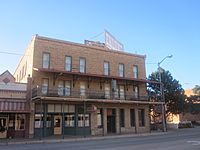
Eklund Hotel (established 1905), 2010.
-
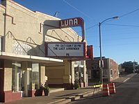
Luna Theater, 2010.
-
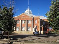
Union County Courthouse, 2010.


Economy
Clayton has a rich history of commerce dating back to its founding in the 1800s. The railroad and nearby ranches caused Clayton to become a major livestock shipping center. A Dr. Pepper bottling plant was in town for a short time before moving back out. The town still thrives as a ranching and farming community, but has expanded its commerce to include multiple eating establishments, numerous shops, several dollar stores, two convenience stores, and multiple motels and campgrounds. The Ranch Market is the town's grocery store which has served the community faithfully for many years. Main Street and First Street are lined with shops including two flower stores and the town's western wear store: Ropes Western Wear and Casual. The town still maintains its small-town, country charm as the historic Hotel Eklund and the Luna Theater have been in operation for more than one hundred years, standing as a reminder to the town's earlier, simpler days.
Transportation
Highway connections include US Route 412 and US Route 64 concurrently through town running generally southwest to northeast, as well as US Route 87 running generally northwest to southeast.
Clayton Municipal Airpark two miles east of town (KCAO, or FAA Identifier CAO), opened in December of 1946, and features two runways the longer of which is 6307 x 75 feet (1922 x 23 meters). Currently there is no scheduled passenger service.
Railroad freight service is provided by BNSF. Passenger service ceased on September 11, 1967.
See also
 In Spanish: Clayton (Nuevo México) para niños
