Clayton County, Iowa facts for kids
Quick facts for kids
Clayton County
|
|
|---|---|

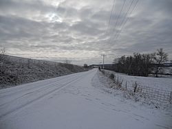
Winter scene near Elkader
|
|

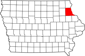
Location within the U.S. state of Iowa
|
|
 Iowa's location within the U.S. |
|
| Country | |
| State | |
| Founded | 1837 |
| Named for | John M. Clayton |
| Seat | Elkader |
| Largest city | Guttenberg |
| Area | |
| • Total | 793 sq mi (2,050 km2) |
| • Land | 779 sq mi (2,020 km2) |
| • Water | 14 sq mi (40 km2) 1.8% |
| Population
(2020)
|
|
| • Total | 17,043 |
| • Density | 21.492/sq mi (8.298/km2) |
| Time zone | UTC−6 (Central) |
| • Summer (DST) | UTC−5 (CDT) |
| Congressional district | 1st |
Clayton County is a county located in the U.S. state of Iowa. As of the 2020 census, the population was 17,043. Its county seat is Elkader. The county was established in 1837 and was named in honor of John M. Clayton, United States Senator from Delaware and later Secretary of State under President Zachary Taylor.
Contents
Geography
According to the U.S. Census Bureau, the county has a total area of 793 square miles (2,050 km2), of which 779 square miles (2,020 km2) is land and 14 square miles (36 km2) (1.8%) is water. It is the fifth-largest county in Iowa by area.
Adjacent counties
- Allamakee County (north)
- Crawford County, Wisconsin (northeast)
- Grant County, Wisconsin (east)
- Dubuque County (southeast)
- Delaware County (south)
- Buchanan County (southwest)
- Fayette County (west)
- Winneshiek County (northwest)
Major highways
National protected areas
- Driftless Area National Wildlife Refuge (part)
- Effigy Mounds National Monument (part)
- Upper Mississippi River National Wildlife and Fish Refuge (part)
Geology
Clayton County is part of the Driftless Area, a region that completely missed being ice-covered during the last ice age. Streams have deeply carved valleys, while the Mississippi River has spectacular bluffs.
Demographics
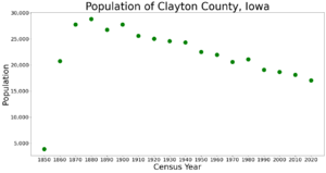
| Historical population | |||
|---|---|---|---|
| Census | Pop. | %± | |
| 1850 | 3,873 | — | |
| 1860 | 20,728 | 435.2% | |
| 1870 | 27,771 | 34.0% | |
| 1880 | 28,829 | 3.8% | |
| 1890 | 26,733 | −7.3% | |
| 1900 | 27,750 | 3.8% | |
| 1910 | 25,576 | −7.8% | |
| 1920 | 25,032 | −2.1% | |
| 1930 | 24,559 | −1.9% | |
| 1940 | 24,334 | −0.9% | |
| 1950 | 22,522 | −7.4% | |
| 1960 | 21,962 | −2.5% | |
| 1970 | 20,606 | −6.2% | |
| 1980 | 21,098 | 2.4% | |
| 1990 | 19,054 | −9.7% | |
| 2000 | 18,678 | −2.0% | |
| 2010 | 18,129 | −2.9% | |
| 2020 | 17,043 | −6.0% | |
| U.S. Decennial Census 1790-1960 1900-1990 1990-2000 2010-2018 |
|||
2020 census
The 2020 census recorded a population of 17,043 in the county, with a population density of 21.5323/sq mi (8.3137/km2). 97.51% of the population reported being of one race. 93.21% were non-Hispanic White, 0.93% were Black, 2.01% were Hispanic, 0.25% were Native American, 0.28% were Asian, 0.04% were Native Hawaiian or Pacific Islander and 3.29% were some other race or more than one race. There were 8,758 housing units of which 7,315 were occupied.
2010 census
The 2010 census recorded a population of 18,130 in the county, with a population density of 23.272/sq mi (8.985/km2). There were 8,999 housing units, of which 7,599 were occupied.
Communities
Cities
Unincorporated communities
- Beulah
- Ceres
- Clayton Center
- Communia
- Eckards
- Elkport
- Fairview
- Froelich
- Giard
- Gunder
- Hardin
- Highland
- Littleport
- McGregor Heights
- Mederville
- Millville
- Motor
- Osborne
- Saint Sebald
- Thomasville
- Turkey River
- Updegraff
- Watson
- Wood
Townships
Clayton County is divided into these townships:
- Boardman
- Buena Vista
- Cass
- Clayton
- Cox Creek
- Elk
- Farmersburg
- Garnavillo
- Giard
- Grand Meadow
- Highland
- Jefferson
- Lodomillo
- Mallory
- Marion
- Mendon
- Millville
- Monona
- Read
- Sperry
- Volga
- Wagner
Population ranking
The population ranking of the following table is based on the 2010 census of Clayton County.
† county seat
{
See also
 In Spanish: Condado de Clayton (Iowa) para niños


