
Clearfield County, Pennsylvania facts for kids
Quick facts for kids
Clearfield County
|
|
|---|---|

|
|

Location within the U.S. state of Pennsylvania
|
|
 Pennsylvania's location within the U.S. |
|
| Country | |
| State | |
| Founded | January 29, 1822 |
| Seat | Clearfield |
| Largest city | DuBois |
| Area | |
| • Total | 1,154 sq mi (2,990 km2) |
| • Land | 1,145 sq mi (2,970 km2) |
| Population | |
| • Estimate
(2018)
|
79,388 |
| • Density | 71/sq mi (27/km2) |
| Time zone | UTC−5 (Eastern) |
| • Summer (DST) | UTC−4 (EDT) |
| Congressional district | 15th |
|
Pennsylvania Historical Marker
|
|
| Designated: | September 17, 1982 |
Clearfield County is a sixth-class county located in the U.S. state of Pennsylvania. As of the 2010 census, the population was 81,642. The county seat is Clearfield, and the largest city is DuBois. The county was created in 1804 and later organized in 1822.
Clearfield County comprises the DuBois, PA Micropolitan Statistical Area, which is also included in the State College-DuBois, PA Combined Statistical Area.
Contents
History
Clearfield County was formed by the Act of Assembly by the second Governor of Pennsylvania at the time, Thomas McKean on March 26, 1804. The county was created from parts of the already created counties of Huntingdon and Lycoming. The name for the county was most likely derived from the many cleared fields of the valleys surrounding Clearfield Creek and West Branch of the Susquehanna River, formed by the bison herds and also by old corn fields of prior Native Americans tribes.
Location of county government
The first board of county commissioners to the county were Roland Curtin, James Fleming and James Smith, all appointed by Governor McKean in 1805. The first act the commissioners did was to create a local government or seat of the newly created county. They came upon land owned at the time by Abraham Witmer at a village known as Chincleclamousche, named after the Native American chief of the Cornplanter's tribe of Senecas. Clearfield became the new name of the old village.
Early industry
The two major industries of the county in the mid-1800s until the early 1900s was lumber and coal. Lumber was still being floated down the West Branch of the Susquehanna up until 1917. Coal remains the main industry of the county to this day.
Geography
According to the U.S. Census Bureau, the county has a total area of 1,154 square miles (2,990 km2), of which 1,145 square miles (2,970 km2) is land and 9.2 square miles (24 km2) (0.8%) is water. It is the third-largest county in Pennsylvania by land area and fourth-largest by total area. The West Branch Susquehanna River flows through the county bisecting the county seat along the way.
The mountainous terrain of the county made traffic difficult for early settlers. Various Native American paths and trails crossing the area were used intermittently by settlers, invading armies, and escaped slaves travelling north along the Underground Railroad. A major feature located in Bloom Township, Pennsylvania within the county is known as Bilger's rocks and exhibits fine examples of exposed sandstone bedrock that was created during the formation of the Appalachian Mountains.
The shape of Clearfield County bears an amazing resemblance to that of the state of Arkansas.
Major highways
 I-80
I-80 US 219
 US 322
 PA 36
PA 36 PA 53
PA 53 US 119
 PA 153
 PA 253
 PA 255
 PA 286
 PA 410
 PA 453
 PA 729
 PA 830
 PA 865
 PA 879
 PA 969
 PA 970
Adjacent counties
- Elk County (north)
- Cameron County (north)
- Clinton County (northeast)
- Centre County (east)
- Blair County (southeast)
- Cambria County (south)
- Indiana County (southwest)
- Jefferson County (west)
Demographics
| Historical population | |||
|---|---|---|---|
| Census | Pop. | %± | |
| 1810 | 875 | — | |
| 1820 | 2,342 | 167.7% | |
| 1830 | 4,803 | 105.1% | |
| 1840 | 7,834 | 63.1% | |
| 1850 | 12,586 | 60.7% | |
| 1860 | 18,759 | 49.0% | |
| 1870 | 25,741 | 37.2% | |
| 1880 | 43,408 | 68.6% | |
| 1890 | 69,565 | 60.3% | |
| 1900 | 80,614 | 15.9% | |
| 1910 | 93,768 | 16.3% | |
| 1920 | 103,236 | 10.1% | |
| 1930 | 86,727 | −16.0% | |
| 1940 | 92,094 | 6.2% | |
| 1950 | 85,957 | −6.7% | |
| 1960 | 81,534 | −5.1% | |
| 1970 | 74,619 | −8.5% | |
| 1980 | 83,578 | 12.0% | |
| 1990 | 78,097 | −6.6% | |
| 2000 | 83,380 | 6.8% | |
| 2010 | 81,642 | −2.1% | |
| 2020 | 80,562 | −1.3% | |
As of the census of 2000, there were 83,382 people, 32,785 households, and 22,916 families residing in the county. The population density was 73 people per square mile (28/km2). There were 37,855 housing units at an average density of 33 per square mile (13/km2). The racial makeup of the county was 97.40% White, 1.49% Black or African American, 0.12% Native American, 0.26% Asian, 0.01% Pacific Islander, 0.26% from other races, and 0.46% from two or more races. 0.56% of the population were Hispanic or Latino of any race. 22.9% were of German, 13.6% American, 10.2% English, 9.9% Irish, 9.1% Italian and 6.0% Polish ancestry.
There were 32,785 households, out of which 29.70% had children under the age of 18 living with them, 56.60% were married couples living together, 9.30% had a female householder with no husband present, and 30.10% were non-families. 26.30% of all households were made up of individuals, and 13.10% had someone living alone who was 65 years of age or older. The average household size was 2.44 and the average family size was 2.94.
In the county, the population was spread out, with 22.70% under the age of 18, 7.70% from 18 to 24, 28.80% from 25 to 44, 23.90% from 45 to 64, and 16.90% who were 65 years of age or older. The median age was 39 years. For every 100 females there were 99.50 males. For every 100 females age 18 and over, there were 97.50 males.
Micropolitan Statistical Area

The United States Office of Management and Budget has designated Clearfield County as the DuBois, PA Micropolitan Statistical Area (µSA). As of the 2010 U.S. Census the micropolitan area ranked 6th most populous in the State of Pennsylvania and the 64th most populous in the United States with a population of 81,642. Clearfield County is also a part of the State College-DuBois, PA Combined Statistical Area (CSA), which combines the populations of both Clearfield and Centre County areas, as well as the State College area. The Combined Statistical Area ranked 9th in the State of Pennsylvania and 123rd most populous in the United States with a population of 235,632.
Recreation
There are two Pennsylvania state parks in Clearfield County.
Clearfield County is also home to the largest wild area in Pennsylvania, the Quehanna Wild Area. A culturally and historically significant natural formation of massive sandstone megaliths can be found at Bilger's rocks.
Camping
Lodging/Camping
| Campground # | Name | Location | Campsites | Swimming | Fishing | Hunting |
|---|---|---|---|---|---|---|
| 2515 | Woodland Campground | Woodland | 70 | yes | yes | yes |
Hunting/fishing
Hunting
| SGL# | Location | Hunting Area | Acreage | Species |
|---|---|---|---|---|
| 34 | Medix Run | Benezette, Covington, Girard, Goshen Townships | 8,000 | bear, dear, turkey |
| 77 | Clear Run | Sandy Township | 3,038 | bear, dear, rabbit, squirrel |
| 78 | Bigler | Bradford & Graham Townships | 721 | bear, deer, turkey |
| 87 | Irishtown | Bell & Penn Townships | 10,422 | dear, grouse, turkey |
| 90 | Goshen | Goshen & Lawrence Townships | 3,958 | bear, deer, turkey |
| 93 | Sabula | Union & Huston Townships | 4,876 | bear, deer, turkey |
| 94 | Lecontes Mills | Goshen & Lawrence Townships | 2,108 | bear, deer, turkey |
| 98 | Blue Ball (West Decatur) | Boggs & Decatur Townships | 1,172 | dear, rabbit, turkey |
Fishing
| Lake/stream | Location | Tributary of |
|---|---|---|
| Bear Run Reservoir | Pike Township | West Branch of the Susquehanna River |
| Chest Creek | Chest Township | West Branch of the Susquehanna River |
| Clearfield Reservoir | Pike Township | West Branch of the Susquehanna River |
| Curwensville Lake | Pike Township | West Branch of the Susquehanna River |
| DuBois Reservoir | Union Township near Home Camp | |
| Duck Marshes | northern Girard Township near Elk County line | |
| Irvona Reservoir | Chest Township | Clearfield Creek |
| Lake Sabula | Sandy Township near Sabula | |
| Laurel Run (Bennett Branch Sinnemahoning Creek) | Huston Township in Parker Dam State Park | Bennett Branch of Sinnemahoning Creek |
| Moose Creek Reservoir | Lawrence Township near Mt. Joy | West Branch of the Susquehanna River |
| Parker Lake | Huston Township in Parker Dam State Park | Bennett Branch of Sinnemahoning Creek |
| Penfield Reservoir | Huston Township near Hoovertown | Bennett Branch of Sinnemahoning Creek |
| Treasure Lake | Sandy Township Treasure Lake | |
| Tyler Reservoir | Huston Township near Tyler | Bennett Branch of Sinnemahoning Creek |
| West Branch of the Susquehanna River | Most of central & eastern Clearfield County including Mahaffey, Curwensville, and Clearfield | Susquehanna River |
Sporting
Golf
| Course # | Name | Location | Holes | Website |
|---|---|---|---|---|
| 3133 | Chetremon Golf Course | 2 miles north of Cherry Tree in Burnside Township Clearfield County | 10 | http://www.chetremon.com/ |
| 3274 | Grandview Golf Club | 1 mile south of Lumber City | 18 | http://www.golfnow.com/course-directory/pennsylvania-golf-courses/curwensville-golf-courses/grandview-golf-club |
Points of interest
- Bilger's Rocks
- Clearfield Armory
- Dimeling Hotel
- McGees Mills Covered Bridge
- St. Severin's Old Log Church
Communities
.jpg)
Under Pennsylvania law, there are four types of incorporated municipalities: cities, boroughs, townships, and, in at most two cases, towns. The following cities, boroughs and townships are located in Clearfield County:
City
Boroughs
Townships
- Beccaria
- Bell
- Bigler
- Bloom
- Boggs
- Bradford
- Brady
- Burnside
- Chest
- Cooper
- Covington
- Decatur
- Ferguson
- Girard
- Goshen
- Graham
- Greenwood
- Gulich
- Huston
- Jordan
- Karthaus
- Knox
- Lawrence
- Morris
- Penn
- Pike
- Pine
- Sandy
- Union
- Woodward
Census-designated places
Census-designated places are geographical areas designated by the U.S. Census Bureau for the purposes of compiling demographic data. They are not actual jurisdictions under Pennsylvania law. Other unincorporated communities, such as villages, may be listed here as well.
- Allport
- Bigler
- Grassflat
- Hawk Run
- Hyde
- Kylertown
- Morrisdale
- Oklahoma
- Plymptonville
- Sandy
- Treasure Lake
- West Decatur
Unincorporated communities
Unincorporated areas are region of land that are not parts of any incorporated boroughs, cities, or towns.
- Helvetia
- Lumber City
- New Castle (Clearfield County) – in Decatur Township
- Sylvan Grove
- Viola
Population ranking
The population ranking of the following table is based on the 2010 census of Clearfield County.
† county seat
| Rank | City/Town/etc. | Population (2010 Census) | Municipal type | Incorporated |
|---|---|---|---|---|
| 1 | DuBois | 7,794 | City | 1881 (borough) 1914 (city) |
| 2 | † Clearfield | 6,215 | Borough | 1840 |
| 3 | Treasure Lake | 3,861 | CDP | |
| 4 | Curwensville | 2,542 | Borough | 1851 |
| 5 | Sandy | 1,429 | CDP | |
| 6 | Hyde | 1,399 | CDP | |
| 7 | Osceola Mills | 1,141 | Borough | 1864 |
| 8 | Falls Creek (mostly in Jefferson County) | 1,037 | Borough | |
| 9 | Plymptonville | 981 | CDP | |
| 10 | Chester Hill | 883 | Borough | 1883 |
| 11 | Houtzdale | 797 | Borough | 1872 |
| 12 | Oklahoma | 782 | CDP | |
| 13 | Morrisdale | 754 | CDP | |
| 14 | Irvona | 647 | Borough | 1890 |
| 15 | Hawk Run | 534 | CDP | |
| 16 | West Decatur | 533 | CDP | |
| 17 | Coalport | 523 | Borough | 1883 |
| 18 | Grassflat | 511 | CDP | |
| 19 | Ramey | 451 | Borough | 1878 |
| 20 | Brisbin | 411 | Borough | 1883 |
| 21 | Bigler | 398 | CDP | |
| 22 | Westover | 390 | Borough | 1895 |
| 23 | Mahaffey | 368 | Borough | 1889 |
| 24 | Grampian | 356 | Borough | 1885 |
| 25 | Kylertown | 340 | CDP | |
| 26 | Wallaceton | 313 | Borough | 1873 |
| 27 | Allport | 264 | CDP | |
| 28 | Troutville | 243 | Borough | 1890 |
| 29 | Burnside | 234 | Borough | 1874 |
| 30 | Glen Hope | 142 | Borough | 1878 |
| 31 | Newburg | 92 | Borough | 1885 |
| 32 | New Washington | 59 | Borough | 1859 |
Education
Colleges and universities
- Lock Haven University of Pennsylvania at Clearfield, Pennsylvania
- Pennsylvania State University at DuBois

Community, junior and technical colleges
- Clearfield County Career and Technology Center
- Triangle Tech
Public school districts
- Clearfield Area School District
- Curwensville Area School District
- DuBois Area School District (also in Jefferson County)
- Glendale School District (also in Cambria County)
- Harmony Area School District (also in Indiana County)
- Moshannon Valley School District
- Philipsburg-Osceola Area School District (also in Centre County)
- Purchase Line School District (also in Indiana County)
- West Branch Area School District (also in Clinton County)
Intermediate unit
- Central IU 10 – West Decatur
Correctional institution schools
- Quehanna Boot Camp – Karthaus
- SCI-Houtzdale – Houtzdale
- Clearfield County Jail-Clearfield
Private schools
- Butchers Run Amish School
- Clearfield Alliance Christian School
- DuBois Area Catholic Elementary School
- DuBois Area Catholic High School
- DuBois Christian Schools
- Golden Yoke School
- Milestones Achievement Center
- Mount Calvary Christian Academy
- New Story (DuBois)
- Otterbein Christian Academy
- Paint & Play School (DuBois)
- Scenic View School
- St Francis Grade School
- Weber Road School
Libraries
- Clearfield County Public Library – Curwensville
- Curwensville Public Library
- DuBois Public Library –
- Glendale Public Library – Coalport
- Joseph and Elizabeth Shaw Public Library – Clearfield
Notable people
- Mary Elizabeth Willson (1842–1906), gospel singer, singer, composer, evangelist
- Willie Adams, major league baseball pitcher (1912–1919)
- Howie Bedell, major league baseball player
- William Bigler (January 1, 1814 – August 9, 1880), American politician, 12th Governor of Pennsylvania from 1852 to 1855, later U.S. Senator for Pennsylvania from 1856 until 1861.
- Earl Caldwell, former reporter and columnist for The New York Times; first African-American to have a regular column in a major national newspaper. Central figure in a major Supreme Court case about the protection of journalists' sources. Currently hosts Pacifica's WBAI radio (New York City)
- Alex Donahue Artist, Designer
- Otto Eppers, cartoonist/illustrator who as part of a stunt successfully jumped off the Brooklyn Bridge at 17 years of age
- Howard Fargo, former member of the Pennsylvania House of Representatives (1981–2000)
- Anthony A. Mitchell, clarinetist, composer and conductor. Led the United States Navy Band from 1962 to 1968.
- Rembrandt Cecil Robinson (1924–1972) was a United States Navy officer (Rear admiral)[17]
- Edward Scofield, governor of Wisconsin (1897–1901)
- William Irvin Swoope, Republican member of the U.S. House of Representatives (1923–27)
- William A. Wallace, Democratic U.S. senator who served from 1875 to 1881
- Powell Weaver, composer and organist
Images for kids
-
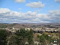
Clearfield, the county seat

See also
 In Spanish: Condado de Clearfield para niños
