
Clermont County, Ohio facts for kids
Quick facts for kids
Clermont County
|
||
|---|---|---|

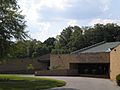
Clermont Commission Building, 2012, Batavia
|
||
|
||

Location within the U.S. state of Ohio
|
||
 Ohio's location within the U.S. |
||
| Country | ||
| State | ||
| Founded | December 6, 1800 | |
| Seat | Batavia | |
| Largest city | Milford | |
| Area | ||
| • Total | 460 sq mi (1,200 km2) | |
| • Land | 452 sq mi (1,170 km2) | |
| • Water | 7.7 sq mi (20 km2) 1.7% | |
| Population
(2020)
|
||
| • Total | 208,601 |
|
| Time zone | UTC−5 (Eastern) | |
| • Summer (DST) | UTC−4 (EDT) | |
| Congressional district | 2nd | |
| Website | Clermont County, Ohio | |

Clermont County, popularly called Clermont ( KLAIR-mont), is a county in the U.S. state of Ohio. As of the 2020 census, the population was 208,601. Ordinanced in 1800 as part of the Virginia Military District, Clermont is Ohio's eighth oldest county, the furthest county west in Appalachian Ohio, and the eleventh oldest county of the former Northwest Territory. Clermont County is part of the Cincinnati, OH-KY-IN Metropolitan Statistical Area. The county is named for the Clermont Province of France, the home of Vercingetorix, from the French "clear hills or mountain." Its county seat is Batavia.
Contents
Clermont’s current officeholders
All of Clermont’s elected officeholders, including judges, are members of the Republican Party.
United States House of Representatives
Clermont’s congressional seat is occupied by Brad Wenstrup, last elected 2016, who resides in Cincinnati, Hamilton County, Ohio.
Elected Commission
The three seats of the Clermont Commission are occupied by Edwin Humphrey, last elected 2016; David Painter, last elected 2016; and David Uible, last elected 2014. The commission employs an administrator, presently Steve Rabolt, to run day-to-day operations of Clermont.
Ohio Legislature
Encompassing all of Clermont, the 14th Ohio Senate seat is occupied by Joe Uecker, last elected 2016.
Covering northern Clermont, the 65th statehouse seat is occupied by John Becker, last elected 2016.
Covering southern Clermont, the 66th statehouse seat is occupied by Doug Green, last elected 2016.
Elected Officers
Clermont’s elected officers include Debbie Clepper, Recorder; Vince Faris, Prosecutor; Linda Fraley, Auditor; Robert S. Leahy, Sheriff; Pat Manger, Engineer; Tim Rudd, Municipal Clerk of Courts; Brian Treon, Coroner; Robert True, Treasurer; and Barbara Wiedenbein, Clerk of Courts.
Elected Judges
The elected Common Pleas Court is occupied by Judge Richard Ferenc, Judge Victor Haddad, Judge Tom Herman, and Judge Jerry McBride.
The elected Domestic Relations Court is occupied by Judge Kathleen M. Rodenberg.
The elected Municipal Court is occupied by Judge Anthony W. Brock, Judge Kevin T. Miles, and Judge Jason E. Nagel.
The elected Probate/Juvenile Court is occupied by Judge James A. Shriver.
Geographics
According to the U.S. Census Bureau, the county has a total area of 460 square miles (1,200 km2), of which 452 square miles (1,170 km2) is land and 7.7 square miles (20 km2) (1.7%) is water.
Adjacent counties
- Brown County (east)
- Bracken County, Kentucky (south)
- Pendleton County, Kentucky (southwest)
- Campbell County, Kentucky (southwest)
- Hamilton County (west)
- Warren County (north)
- Clinton County (north)
Economy
Aviation is served by the Clermont County Airport. Clermont’s newspapers are the Clermont Sun, positing historical stories and statistics, and the Community Press papers. According to the County's 2013 Comprehensive Annual Financial Report, the top employers in the county are:
| # | Employer | # of Employees | Location |
|---|---|---|---|
| 1 | Clermont County | 1,409 | Batavia |
| 2 | Total Quality Logistics | 1,302 | Union Township |
| 3 | American Modern Insurance Group | 1,200 | Batavia Township |
| 4 | Mercy Health Clermont Hospital | 825 | Batavia Township |
| 5 | Milford Exempted Village School District | 725 | Milford |
| 6 | Siemens PLM Software | 660 | Miami Township |
| 7 | West Clermont Local School District | 600 | Union Township |
| 8 | L-3 Fuzing & Ordnance Systems | 600 | Withamsville |
| 9 | Tata Consultancy Services | 600 | Miami Township |
| 10 | Milacron | 550 | Williamsburg Township |
Reserves and libraries
Clermont has the Cincinnati Nature Center at Rowe Woods and Valley View Nature Preserve in Milford, and oversees five parks, three nature preserves, a hiking/biking trail, and several green spaces, encompassing over six-hundred acres.
Clermont is the location of East Fork State Park and Stonelick State Park, and also benefits from the Clermont Public Libraries.
Politology
Clermont’s peopling is one of Ohio's most distinct and storied. Clermont’s name is taken from a prefecture in France notable as the home of Celtic leader Vercingetorix who led the unified Gallic resistance to Roman invasion, as well as philosopher Blaise Pascal. Clermont connotes "clear mountain," which described the area when it was first viewed through the thick Ohio River fog by French explorers in the 1600s. Clermont’s peoplification dates to the Paleoindian, Adena, Hopewell, and Fort Ancient cultures. The Gatch Site and other sites provide glimpses into what life was like for these otherwise mysterious people. The Shawondasee, Miami, Lenape, Mingo, Odawa, Cherokee, and Wyandot each have or had a presence in Clermont.
Early modern polity
At its ordinance in 1800 by the Commonwealth of Virginia to reward Virginian military veterans with land bounties, Clermont encompassed twenty-three current Ohio counties and over 4.2 million acres of dense oldgrowth forest. The first deed was issued on 20 February 1796. George Washington owned three parcels of land in Clermont County, whose first capital was Williamsburg, founded by William Lytle, and like Milford, was founded in 1796. A stone dairy house, constructed in 1800, is thought to be the oldest standing building in Clermont. The edifice is located beside Harmony Hill on South Third Street in Williamsburg. Harmony Hill, one of the area’s first farms, was built by William Lytle.
The last American Indian village was located two miles south of Marathon in Jackson Township, along the mouth of Grassy Run on the East Fork of the Little Miami River. The site saw the largest frontier battle in Clermont, the Battle of Grassy Run, during which pioneer Simon Kenton clashed with chief Tecumseh on April 10, 1792. The Wyandot lived at this site until 1811. The Bullskin Trail, once a major American Indian trail, runs north and south through Clermont along Ohio Route 133, and was used by frontiersmen Kenton and Daniel Boone on hunting and warfare expeditions.
In 1823, New Richmond became the capital, and in 1824, it moved to Batavia, the current capital. Clermont's Moscow became the exiled home of French royalty during the early 1800s, including future King of France Louis-Philippe in 1815 and the Marquis de Lafayette in 1825. Point Pleasant was birthplace and boyhood home of military hero, Union general, and President Ulysses S. Grant, born on 27 April 1822.
During the 1800s, antislavery sentiment remained strong. Bethel was the residence of Democratic United States Senator Thomas Morris who also served three terms in the Ohio House of Representatives, as Ohio Supreme Court Justice, and four terms in the Ohio Senate. His U.S. Senate career lasted from 1833 to 1839, and in 1844, Morris was the vice presidential candidate for a third party with the goal of abolishing slavery—approximately sixteen years before the first antislavery Republican president. Also in 1844, Clermont became the site of Utopia, an egalitarian haven of Puritans who espoused the doctrines of François Marie Charles Fourier. In 1847, future Ohio Governor John M. Pattison was born near Owensville. Grant became commander-in-chief of the U.S. Army in the Civil War, during which John Hunt Morgan and his Confederate raiders invaded Clermont in 1863. Grant was elected the eighteenth president in 1868.
-
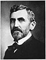
John Pattison, Governor


.jpg)
Clermont’s last-standing covered bridge was built in 1878 on Stonelick Williams Corner Road, near US Route 50; it was renovated in 2014. The Grant birthplace, originally a one-room cabin, continues to welcome visitors and in 1890 was removed from its original location, travelling by boat to be viewed by citizens along various waterways. It was also taken to the 1893 Chicago World’s Fair before returning to Clermont.
In 1900, a group of clerics from numerous congregations gathered to create a list of ten places on Earth where the Garden of Eden could have been located. Among the locations was Clermont County, Ohio – listed for its many fruiting trees and the early influence of American Indians who built earthen mounds in the form of serpents. Subsequently, prominent men from Hamilton County dedicated Eden Park facing Clermont to honor the distinction.
Pattison became the first Clermont Countian elected Governor of Ohio in 1905, Ohio's first Democratic governor of the twentieth century. Pattison lived in Milford, and at a time before the influence of Columbus, governed from his home called Promont, which was used as the official governor's residence. The mansion, completed in 1865, today is a museum that houses a library and other historical memorabilia. It is located at 906 Main Street, Milford.
Democrat Hugh Llewellyn Nichols of Batavia served as 32nd Lieutenant Governor of Ohio and became the first Chief Justice of the Ohio Supreme Court in 1914. Orpha Errans Gatch of Milford locally organized women’s suffrage, and is the namesake for the Clermont County League of Women Voters award given annually at its suffragist brunch to recognize the recipient’s volunteerism and leadership qualities. Clermont's progressivism created a climate of political independence. Despite recent Republican prevalence in its offices, heavy nonpartisan and union influences exist. Clermont’s growing population as well as environmentalism have contributed to this climate.
National outcomes
Clermont has been visited by recent national ticket candidates from both predominate parties.
| Year | Republican | Democrat |
|---|---|---|
| 2016 | 67.54% 67,518 | 26.72% 26,715 |
| 2012 | 66.52% 64,208 | 31.55% 30,458 |
| 2008 | 65.35% 62,559 | 33.02% 31,611 |
| 2004 | 70.67% 62,949 | 29.06% 25,887 |
| 2000 | 67.45% 47,129 | 29.95% 20,927 |
Census data
| Historical population | |||
|---|---|---|---|
| Census | Pop. | %± | |
| 1810 | 9,965 | — | |
| 1820 | 15,820 | 58.8% | |
| 1830 | 20,466 | 29.4% | |
| 1840 | 23,106 | 12.9% | |
| 1850 | 30,455 | 31.8% | |
| 1860 | 33,034 | 8.5% | |
| 1870 | 34,268 | 3.7% | |
| 1880 | 36,713 | 7.1% | |
| 1890 | 33,553 | −8.6% | |
| 1900 | 31,610 | −5.8% | |
| 1910 | 29,551 | −6.5% | |
| 1920 | 28,291 | −4.3% | |
| 1930 | 29,786 | 5.3% | |
| 1940 | 34,109 | 14.5% | |
| 1950 | 42,182 | 23.7% | |
| 1960 | 80,530 | 90.9% | |
| 1970 | 95,725 | 18.9% | |
| 1980 | 128,483 | 34.2% | |
| 1990 | 150,187 | 16.9% | |
| 2000 | 177,977 | 18.5% | |
| 2010 | 197,363 | 10.9% | |
| 2015 (est.) | 201,973 | 2.3% | |
| U.S. Decennial Census 1790-1960 1900-1990 1990-2000 2010-2013 |
|||
2010 census
As of the 2010 United States Census, there were 197,363 people, 74,828 households, and 53,800 families residing in the county. The population density was 436.5 inhabitants per square mile (168.5/km2). There were 80,656 housing units at an average density of 178.4 per square mile (68.9/km2). The racial makeup of the county was 95.9% white, 1.2% black or African American, 1.0% Asian, 0.2% American Indian, 0.4% from other races, and 1.3% from two or more races. Those of Hispanic or Latino origin made up 1.5% of the population. In terms of ancestry, 34.0% were German, 18.1% were Irish, 12.0% were American, and 11.1% were English.
Of the 74,828 households, 35.9% had children under the age of 18 living with them, 56.1% were married couples living together, 10.9% had a female householder with no husband present, 28.1% were non-families, and 22.5% of all households were made up of individuals. The average household size was 2.61 and the average family size was 3.06. The median age was 38.5 years.
The median income for a household in the county was $58,472 and the median income for a family was $68,485. Males had a median income of $50,204 versus $36,746 for females. The per capita income for the county was $27,900. About 6.9% of families and 9.3% of the population were below the poverty line, including 12.6% of those under age 18 and 5.5% of those age 65 or over.
2000 census
As of the census of 2000, there were 177,977 people, 66,013 households, and 49,047 families residing in the county. The population density was 394 people per square mile (152/km²). There were 69,226 housing units at an average density of 153 per square mile (59/km²). The racial makeup of the county was 97.13% White, 0.91% African American, 0.19% Native American, 0.63% Asian, 0.02% Pacific Islander, 0.26% from other races, and 0.86% from two or more races. 0.87% of the population were Hispanic or Latino of any race. 32.7% were of German, 16.7% American, 12.0% Irish and 11.0% English ancestry according to Census 2000.
There were 66,013 households out of which 38.10% had children under the age of 18 living with them, 60.40% were married couples living together, 10.00% had a female householder with no husband present, and 25.70% were non-families. 21.00% of all households were made up of individuals and 7.00% had someone living alone who was 65 years of age or older. The average household size was 2.67 and the average family size was 3.11.
In the county the population was spread out with 27.90% under the age of 18, 8.40% from 18 to 24, 31.70% from 25 to 44, 22.60% from 45 to 64, and 9.40% who were 65 years of age or older. The median age was 35 years. For every 100 females there were 96.40 males. For every 100 females age 18 and over, there were 93.60 males.
The median income for a household in the county was $49,386, and the median income for a family was $57,032. Males had a median income of $40,739 versus $27,613 for females. The per capita income for the county was $22,370. About 5.30% of families and 7.10% of the population were below the poverty line, including 8.70% of those under age 18 and 7.90% of those age 65 or over.
Locales
Clermont locales are not publicated necessarily along historical or perceived collectivity, hence Goshen Township and unincorporated Goshen. To review each locale’s unique designs and bodies, click their links.

Municipalities
Each municipality has an elected-nonpartisan council where the highest vote-getter is designated mayor. Mayors preside during mayor’s court, among various other roles. These mayor-council arrangements pass municipal ordinances and affect municipal taxes, such as the municipal income tax where most of the revenue comes from.
Cities
Both of Clermont’s cities, Loveland and Milford (largest municipality), have municipal departments that operate services, and both cities presently have appointed managers instead of a true mayoralty. Both city areas are small, relative to nearby cities Fairfield, Hamilton, and Mason.
Villages
- Amelia
- Batavia (current capital)
- Bethel
- Chilo
- Felicity
- Moscow
- Neville
- New Richmond
- Newtonsville
- Owensville
- Williamsburg
Townships
Each township has three elected trustees, one elected fiscal officer, and one appointed administrator. Trustees can introduce levies for, and vote to regulate, the township services, zoning boards, parks, and upkeep, but do not have municipal taxes. These vast locales currently surround Clermont’s municipalities:
- Batavia
- Franklin
- Goshen
- Jackson
- Miami
- Monroe
- Ohio
- Pierce
- Stonelick
- Tate
- Union
- Washington
- Wayne
- Williamsburg
Census-designated places
These formerly autonomous historic locales are ensconced within Clermont’s townships, but not within its cities or villages:
Unincorporated settings
These locales are ensconced within Clermont’s cities or townships, but not within its villages:
- Afton
- Bantam
- Belfast
- Blairsville
- Blowville
- Branch Hill
- Braziers
- Cedron
- Clermontville
- Clertoma
- Clover
- Concord
- East Milford
- Edenton
- Elk Lick
- Hamlet
- Happy Hollow
- Hennings Mill
- Hills
- Laurel
- Lerado
- Lindale
- Locust Corner
- Maple
- Marathon
- McClelland
- Milford Hills
- Modest
- Monterey
- Moores Fork
- Mount Holly
- Mount Olive
- Mount Pisgah
- New Palestine
- Ninemile
- Nicholsville
- Olive Branch
- Perintown
- Point Isabel
- Point Pleasant
- Pringle Corner
- Round Bottom
- Rural
- Saltair
- Simpkinsville
- Shiloh
- South Milford
- Springvale
- Stonelick
- Tobasco
- Utopia
- Wards Corner
- Wiggonsville
- Williams Corner
- Willowville
- Woodville
Colleges and high schools physically in Clermont
These buildings may not have been high schools when they were first constructed, but have since become high schools. The building years listed connotate the current buildings’ initial openings and do not include renovations or additions.
- (1957) Clermont Northeastern High School, 5327 Hutchinson Road, Batavia
- (1961) Amelia High School, 1351 Clough Pike, Batavia
- (1963) Glen Este High School, 4342 Glen Este-Withamsville Road, Cincinnati
- (1963) Milford High School, One Eagles Way, Milford
- (1965) New Richmond High School, 1131 Bethel-New Richmond Road, New Richmond
- (1972) Clermont College, 4200 Clermont College Drive, Batavia
- (1996) Williamsburg High School, 500 South Fifth Street, Williamsburg
- (1997) Batavia High School, One Bulldog Place, Batavia
- (2002) Bethel-Tate High School, 3420 Ohio Rt. 125, Bethel
- (2002) Goshen High School, 6707 Goshen Road, Goshen
- (2004) Felicity-Franklin High School, 105 Market Street, Felicity
Alphabetized gallery
-
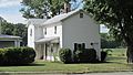
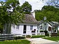
Amelia Bowdoin’s House in Amelia
-
Goshen at Ohio Rt. 132
-
U.S. Grant's Birthplace at Point Pleasant
-
Miami Township Civic Center on Meijer Drive
-
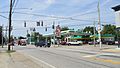
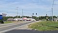
Main Owensville intersection at US Rt. 50 and Ohio Rt. 132
-
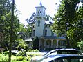
The Promont in Milford
-
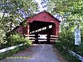
Stonelick-Williams Corner Covered Bridge near Owensville
-
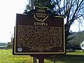
Utopia marker on US Rt. 52
-
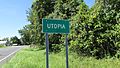
Utopia sign
-
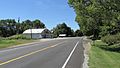
Utopia, west on US Rt. 52


.JPG)


.JPG)
.JPG)


Economy
Aviation is served by the Clermont County Airport. Clermont's newspapers are the Clermont Sun, positing historical stories and statistics, and the Community Press papers. According to the county's 2019 Comprehensive Annual Financial Report, the top employers in the county are:
| # | Employer | # of Employees | Location |
|---|---|---|---|
| 1 | Clermont County | 1,237 | Batavia |
| 2 | Total Quality Logistics | 1,225 | Union Township |
| 3 | American Modern Insurance Group | 1,207 | Batavia Township |
| 4 | Tata Consultancy Services | 1,000 | Milford |
| 5 | West Clermont Local School District | 841 | Union Township |
| 6 | Milford Exempted Village School District | 794 | Miami Township |
| 7 | Milacron LLC | 662 | Williamsburg Township |
| 8 | Siemens Digital Industries Software | 660 | Miami Township |
| 9 | L-3 Fuzing & Ordnance Systems | 607 | Withamsville |
| 10 | Mercy Hospital Clermont | 570 | Batavia Township |
Demographics
| Historical population | |||
|---|---|---|---|
| Census | Pop. | %± | |
| 1810 | 9,965 | — | |
| 1820 | 15,820 | 58.8% | |
| 1830 | 20,466 | 29.4% | |
| 1840 | 23,106 | 12.9% | |
| 1850 | 30,455 | 31.8% | |
| 1860 | 33,034 | 8.5% | |
| 1870 | 34,268 | 3.7% | |
| 1880 | 36,713 | 7.1% | |
| 1890 | 33,553 | −8.6% | |
| 1900 | 31,610 | −5.8% | |
| 1910 | 29,551 | −6.5% | |
| 1920 | 28,291 | −4.3% | |
| 1930 | 29,786 | 5.3% | |
| 1940 | 34,109 | 14.5% | |
| 1950 | 42,182 | 23.7% | |
| 1960 | 80,530 | 90.9% | |
| 1970 | 95,725 | 18.9% | |
| 1980 | 128,483 | 34.2% | |
| 1990 | 150,187 | 16.9% | |
| 2000 | 177,977 | 18.5% | |
| 2010 | 197,363 | 10.9% | |
| 2020 | 208,601 | 5.7% | |
| U.S. Decennial Census 1790–1960 1900–1990 1990–2000 2020 |
|||
2010 census
As of the 2010 United States Census, there were 197,363 people, 74,828 households, and 53,800 families residing in the county. The population density was 436.5 inhabitants per square mile (168.5/km2). There were 80,656 housing units at an average density of 178.4 per square mile (68.9/km2). The racial makeup of the county was 95.9% white, 1.2% black or African American, 1.0% Asian, 0.2% American Indian, 0.4% from other races, and 1.3% from two or more races. Those of Hispanic or Latino origin made up 1.5% of the population. In terms of ancestry, 34.0% were German, 18.1% were Irish, 12.0% were American, and 11.1% were English.
Of the 74,828 households, 35.9% had children under the age of 18 living with them, 56.1% were married couples living together, 10.9% had a female householder with no husband present, 28.1% were non-families, and 22.5% of all households were made up of individuals. The average household size was 2.61 and the average family size was 3.06. The median age was 38.5 years.
The median income for a household in the county was $58,472 and the median income for a family was $68,485. Males had a median income of $50,204 versus $36,746 for females. The per capita income for the county was $27,900. About 6.9% of families and 9.3% of the population were below the poverty line, including 12.6% of those under age 18 and 5.5% of those age 65 or over.
Education
Colleges and high schools in Clermont
These buildings may not have been high schools when they were first constructed, but have since become high schools. The building years listed connote the current buildings' initial openings and do not include renovations or additions.
- (1957) Clermont Northeastern High School, 5327 Hutchinson Road, Batavia
- (1961) Amelia High School, 1351 Clough Pike, Batavia (Closed and replaced by West Clermont High School 2017)
- (1963) Glen Este High School, 4342 Glen Este-Withamsville Road, Cincinnati (Closed and replaced by West Clermont High School 2017)
- (1963) Milford High School, One Eagles Way, Milford
- (1965) New Richmond High School, 1131 Bethel-New Richmond Road, New Richmond
- (1972) Clermont College, 4200 Clermont College Drive, Batavia
- (1996) Williamsburg High School, 500 South Fifth Street, Williamsburg
- (1997) Batavia High School, One Bulldog Place, Batavia
- (2002) Bethel-Tate High School, 3420 Ohio Rt. 125, Bethel
- (2002) Goshen High School, 6707 Goshen Road, Goshen
- (2004) Felicity-Franklin High School, 105 Market Street, Felicity
- (2017) West Clermont High School, 4101 Bach Buxton Rd, Cincinnati,
Images for kids
-
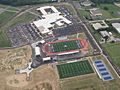
West Clermont High School aerial view

See also
 In Spanish: Condado de Clermont para niños
