
Clinton County, Pennsylvania facts for kids
Quick facts for kids
Clinton County
|
|
|---|---|

Clinton County Courthouse
|
|

Location within the U.S. state of Pennsylvania
|
|
 Pennsylvania's location within the U.S. |
|
| Country | |
| State | |
| Founded | June 21, 1839 |
| Named for | DeWitt Clinton |
| Seat | Lock Haven |
| Largest city | Lock Haven |
| Area | |
| • Total | 897 sq mi (2,320 km2) |
| • Land | 888 sq mi (2,300 km2) |
| • Water | 8.9 sq mi (23 km2) 1.0%% |
| Population | |
| • Estimate
(2020)
|
37,957 |
| • Density | 43/sq mi (17/km2) |
| Time zone | UTC−5 (Eastern) |
| • Summer (DST) | UTC−4 (EDT) |
| Congressional district | 12th |
|
Pennsylvania Historical Marker
|
|
| Designated: | June 12, 1982 |
Clinton County is a county located in the U.S. state of Pennsylvania. As of the 2010 census, the population was 39,238. Its county seat is Lock Haven. The county was created on June 21, 1839, from parts of Centre and Lycoming Counties. Its name is in honor of the seventh Governor of New York State, DeWitt Clinton, however some sources suggest the namesake is Henry Clinton.
Clinton County comprises the Lock Haven, PA Micropolitan Statistical Area, which is also included in the Williamsport-Lock Haven, PA Combined Statistical Area.
Contents
Geography
According to the U.S. Census Bureau, the county has a total area of 897 square miles (2,320 km2), of which 888 square miles (2,300 km2) is land and 8.9 square miles (23 km2) (1.0%) is water.
Adjacent counties
- Potter County (north)
- Lycoming County (east)
- Union County (southeast)
- Centre County (south)
- Clearfield County (southwest)
- Cameron County (west)
Landforms
- ‹See Tfd›Bear Mountain - a USGS GNIS registered mountain peak (Bear Mountain: summit type feature at Latitude/Longitude: 41.0095121,-77.4338743 or 41°00'34"N,077°26'02"W) on the "Mill Hall" topographic map
Demographics
| Historical population | |||
|---|---|---|---|
| Census | Pop. | %± | |
| 1840 | 8,323 | — | |
| 1850 | 11,207 | 34.7% | |
| 1860 | 17,723 | 58.1% | |
| 1870 | 23,211 | 31.0% | |
| 1880 | 26,278 | 13.2% | |
| 1890 | 28,685 | 9.2% | |
| 1900 | 29,197 | 1.8% | |
| 1910 | 31,545 | 8.0% | |
| 1920 | 33,555 | 6.4% | |
| 1930 | 32,319 | −3.7% | |
| 1940 | 34,557 | 6.9% | |
| 1950 | 36,532 | 5.7% | |
| 1960 | 37,619 | 3.0% | |
| 1970 | 37,721 | 0.3% | |
| 1980 | 38,971 | 3.3% | |
| 1990 | 37,182 | −4.6% | |
| 2000 | 37,910 | 2.0% | |
| 2010 | 39,238 | 3.5% | |
| 2020 | 37,450 | −4.6% | |
As of the census of 2000, there were 37,914 people, 14,773 households, and 9,927 families residing in the county. The population density was 43 people per square mile (16/km2). There were 18,166 housing units at an average density of 20 per square mile (8/km2). The racial makeup of the county was 98.3% White, 0.52% Black or African American, 0.1% Native American, 0.4% Asian, <0.1% Pacific Islander, 0.2% from other races, and 0.5% from two or more races. 0.5% of the population were Hispanic or Latino of any race. 36.0% were of German, 15.6% American, 9.6% Irish, 8.6% Italian and 7.4% English ancestry.
There were 14,773 households, out of which 27.7% had children under the age of 18 living with them, 54.0% were married couples living together, 9.4% had a female householder with no husband present, and 32.8% were non-families. 26.6% of all households were made up of individuals, and 13.6% had someone living alone who was 65 years of age or older. The average household size was 2.42 and the average family size was 2.90.
In the county, the population was spread out, with 21.5% under the age of 18, 13.6% from 18 to 24, 25.5% from 25 to 44, 22.7% from 45 to 64, and 16.8% who were 65 years of age or older. The median age was 38 years. For every 100 females there were 94.20 males. For every 100 females age 18 and over, there were 91.20 males.
Micropolitan Statistical Area

The United States Office of Management and Budget has designated Clinton County as the Lock Haven, PA Micropolitan Statistical Area (µSA). As of the 2010 U.S. Census the micropolitan area ranked 16th most populous in the State of Pennsylvania and the 315th most populous in the United States with a population of 39,238. Clinton County is also a part of the Williamsport-Lock Haven, PA Combined Statistical Area (CSA), which combines the population of both Clinton County and the Lycoming County areas. The Combined Statistical Area ranked 11th in the State of Pennsylvania and 143rd most populous in the United States with a population of 155,349.
Recreation
There are five Pennsylvania state parks in Clinton County.
- Bucktail State Park Natural Area is a 75-mile (121 km) scenic route along Pennsylvania Route 120 stretching from Lock Haven to Emporium in Cameron County.
- Hyner Run State Park
- Hyner View State Park
- Kettle Creek State Park
- Ravensburg State Park
Communities

Under Pennsylvania law, there are four types of incorporated municipalities: cities, boroughs, townships, and, in at most two cases, towns. The following cities, boroughs and townships are located in Clinton County:
City
- Lock Haven (county seat)
Boroughs
Townships
- Allison
- Bald Eagle
- Beech Creek
- Castanea
- Chapman
- Colebrook
- Crawford
- Dunnstable
- East Keating
- Gallagher
- Greene
- Grugan
- Lamar
- Leidy
- Logan
- Noyes
- Pine Creek
- Porter
- Wayne
- West Keating
- Woodward
Census-designated places
Census-designated places are geographical areas designated by the U.S. Census Bureau for the purposes of compiling demographic data. They are not actual jurisdictions under Pennsylvania law. Other unincorporated communities, such as villages, may be listed here as well.
Population ranking
The population ranking of the following table is based on the 2010 census of Clinton County.
† county seat
| Rank | City/Town/etc. | Municipal type | Population (2010 Census) |
|---|---|---|---|
| 1 | † Lock Haven | City | 9,772 |
| 2 | Mill Hall | Borough | 1,613 |
| 3 | Avis | Borough | 1,484 |
| 4 | Dunnstown | CDP | 1,360 |
| 5 | Flemington | Borough | 1,330 |
| 6 | Renovo | Borough | 1,228 |
| 7 | Castanea | CDP | 1,125 |
| 8 | Rauchtown (partially in Lycoming County) | CDP | 726 |
| 9 | Beech Creek | Borough | 701 |
| 10 | McElhattan | CDP | 598 |
| 11 | Lamar | CDP | 562 |
| 12 | Rote | CDP | 507 |
| 13 | Loganton | Borough | 468 |
| 14 | South Renovo | Borough | 439 |
Education

Colleges and universities
- Lock Haven University of Pennsylvania
Public school districts
- Jersey Shore Area School District (also in Lycoming County)
- Keystone Central School District (also in Centre County)
- West Branch Area School District (also in Clearfield County)
Images for kids
-
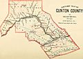
1883 map of Clinton County, with the Philadelphia and Erie Railroad running through the center.
_(14596930247).jpg)
See also
 In Spanish: Condado de Clinton (Pensilvania) para niños
