
Clontarf, Queensland facts for kids
Quick facts for kids ClontarfQueensland |
|||||||||||||||
|---|---|---|---|---|---|---|---|---|---|---|---|---|---|---|---|
 |
|||||||||||||||

Clontarf
Location in Queensland
|
|||||||||||||||
| Population | 8,279 (2016 census) | ||||||||||||||
| • Density | 836/km2 (2,170/sq mi) | ||||||||||||||
| Postcode(s) | 4019 | ||||||||||||||
| Elevation | 12 m (39 ft) | ||||||||||||||
| Area | 9.9 km2 (3.8 sq mi) | ||||||||||||||
| Time zone | AEST (UTC+10:00) | ||||||||||||||
| Location |
|
||||||||||||||
| LGA(s) | Moreton Bay Region | ||||||||||||||
| Region | South East Queensland | ||||||||||||||
| State electorate(s) | Redcliffe | ||||||||||||||
| Federal Division(s) | Petrie | ||||||||||||||
|
|||||||||||||||
Clontarf is a coastal suburb in the Moreton Bay Region, Queensland, Australia. In the 2016 census, Clontarf had a population of 8,279 people.
Clontarf is in the south-west of the Redcliffe Peninsula, approximately 34.4 kilometres (21.4 mi) by road north-northeast of Brisbane, the state capital. It was named after Clontarf in Ireland.
Contents
Attractions and features

Clontarf is connected to Brisbane City, across Bramble Bay, by the Houghton Highway which is a 2.7 km long causeway that provides access to the southern tip of Redcliffe City, greatly decreasing the travel time between Redcliffe and Brisbane. The current pair of bridges, Houghton Highway and its twin Ted Smout Memorial Bridge, replaced the original Hornibrook Bridge which is now closed and mostly demolished.
Clontarf Beach and Bells Beach are two of the closest beaches to Brisbane City.
Pelican Park is known for its kite flying conditions, and a local industry has built around the sport. On weekends, many kites can be seen flying above Clontarf from the Hornibrook Bridge. During May, the Redcliffe Kite Club, based in Clontarf holds a two-day kite event called Kitefest.
Demographics
In the 2011 census, Clontarf recorded a population of 7,911 people, 50.2% female and 49.8% male.
The median age of the Clontarf population was 42 years, 5 years above the national median of 37.
76.2% of people living in Clontarf were born in Australia. The other top responses for country of birth were New Zealand 5.5%, England 5.2%, Scotland 0.8%, Philippines 0.8%, South Africa 0.5%.
90.7% of people spoke only English at home; the next most common languages were 0.4% Tagalog, 0.4% German, 0.3% Dutch, 0.3% Italian, 0.3% Samoan.
Heritage listings
Brighton has a number of heritage-listed sites, including:
- Hornibrook Highway: Hornibrook Bridge (the first of the three bridges)
Public transport
Clontarf is served by several bus routes: Route 315, a limited-stops Monday-Friday service to Brisbane City; Route 693, an internal route within Redcliffe City, and Routes 690 and 695 to Sandgate railway station, an approximately 10- to 15-minute commute. All services are provided by Hornibrook Bus Lines.
The Redcliffe Peninsula line is a 12 km stretch of heavy gauge dual-track railway between Petrie and Kippa-Ring on the Redcliffe peninsula.[1] The new line is part of the QR Citytrain suburban network, branching from the Caboolture line. It starts 200 metres north of Petrie railway station, extending from (27.5 km (17.1 mi) to 40.1 km (24.9 mi) north of Central railway station).
Gallery
-
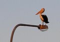
Roosting pelican on the Houghton
-
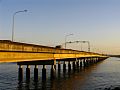
Houghton Highway at sunset
-
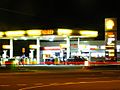
Coles Express Clontarf


Economy

Clontarf's west hosts the largest industrial area in the Redcliffe area, and the area is a significant source of employment for the region. Many residents of Clontarf also commute to Brisbane daily for work. Commuters also travel to Brisbane by Train, as there is now a Train line that connects to the peninsula.
Clontarf is host to two adjacent medium-sized shopping centres, on the southern tip of the suburb. Most retail commerce in the suburb revolves around small business however, and there are many stand alone corner stores and other small businesses still in existence.
Education
Clontarf Beach State School is a government primary (Prep-6) school for boys and girls at Elizabeth Avenue (27°15′12″S 153°04′52″E / 27.2533°S 153.0811°E). In 2018, the school had an enrolment of 451 students with 37 teachers (32 full-time equivalent) and 25 non-teaching staff (14 full-time equivalent). It includes a special education program at Clontarf Beach State School at Elizabeth Avenue (27°15′12″S 153°04′52″E / 27.2533°S 153.0811°E).
Grace Lutheran Primary School is a private primary (Prep-6) school for boys and girls at 38 Maine Road (27°15′15″S 153°05′23″E / 27.2542°S 153.0896°E). In 2018, the school had an enrolment of 393 students with 29 teachers (25 full-time equivalent) and 23 non-teaching staff (13 full-time equivalent).
Clontarf Beach State High School is a government secondary (7-12) school for boys and girls at Cnr Elizabeth Avenue & King Street (27°14′52″S 153°05′10″E / 27.2479°S 153.0861°E). In 2018, the school had an enrolment of 923 students with 78 teachers (76 full-time equivalent) and 42 non-teaching staff (33 full-time equivalent). It includes a special education program.
Images for kids
-
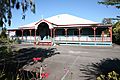
St Peter the Fisherman's Anglican Church, 2008

