
Clugin facts for kids
Quick facts for kids
Clugin
|
||
|---|---|---|
|
||
| Country | Switzerland | |
| Canton | Graubünden | |
| District | Hinterrhein | |
| Area | ||
| • Total | 2.49 km2 (0.96 sq mi) | |
| Elevation | 1,013 m (3,323 ft) | |
| Population | ||
| • Total | 34 | |
| • Density | 13.65/km2 (35.4/sq mi) | |
| Postal code |
7442
|
|
| Surrounded by | Andeer, Casti-Wergenstein, Donat, Pignia | |

Clugin (Romansh: Clugen) is a former municipality in the district of Hinterrhein in the canton of Graubünden in Switzerland.
On 1 January 2009 the former municipalities of Clugin and Pignia merged into the municipality of Andeer.

Images for kids
-
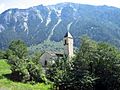
Clugin village church
-
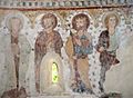
Painting of apostles from the Clugin church


All content from Kiddle encyclopedia articles (including the article images and facts) can be freely used under Attribution-ShareAlike license, unless stated otherwise. Cite this article:
Clugin Facts for Kids. Kiddle Encyclopedia.