
Clwydian Range facts for kids


The Clwydian Range (Welsh: Bryniau Clwyd) is a series of hills in north east Wales that runs from Llandegla in the south to Prestatyn in the north, with the highest point being the popular Moel Famau. The range forms part of the Clwydian Range and Dee Valley (Welsh: AHNE Bryniau Clwyd a Dyffryn Dyfrdwy) Area of Outstanding Natural Beauty.
Contents
Geology
The Clwydian Hills are formed from an upstanding block of deep sea sediments formed during the Silurian period as debris slurries originating on the nearby continental shelf. The older mudstones and siltstones of the Nantglyn Flags Formation form parts of the west-facing scarp slope and the overlying Elwy Formation which consists of mudstones and siltstones deposited in deep marine conditions with numerous sandstone beds form most of the higher ground. Both formations are of Ludlovian age. The range's rocks are intensely faulted; the major Vale of Clwyd Fault is responsible for the impressive west-facing scarp of the Clwydian Range. It downthrows the rocks to the west and separates the younger Carboniferous and Permo-Triassic rocks of the Vale of Clwyd from those of the hills.
Ice from the Welsh ice-sheet moved eastwards over the Clwydian Hills during the last ice age, impinging on the Irish Sea Ice to the east of the range. Numerous glacial meltwater channels occur around the range whilst the valley of the River Wheeler which cuts the range in two was a significant drainage channel.
The hills
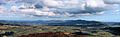
The summits of the hills in the Clwydian Range provide extensive views across northern Wales, to the high peaks of Snowdonia, eastwards across the Cheshire Plain and the Peak District, and towards Manchester and Liverpool in England to the northeast. They have heather-clad summits above rolling pastures. The Offa’s Dyke National Trail traverses the range from Llandegla to Prestatyn.
The range includes a number of hills possessing Iron Age hillforts, including (from the north) Y Foel (Moel Hiraddug), Moel-y-gaer, Penycloddiau, Moel Arthur, a second Moel y Gaer and Foel Fenlli. There are, as with many places in the west of Britain, a number of legends associated with King Arthur surrounding these hills. There are a number of tumuli and cairns on the hills.
Area of Outstanding Natural Beauty
The Clwydian Range was designated as an Area of Outstanding Natural Beauty in 1985, one of only five in Wales. The original area was 167 square kilometres (64 sq mi) but in 2011, the area was extended southwards by a further 229 square kilometres (88 sq mi) to include the Dee Valley, Moel y Gamelin, the Horseshoe Pass and Castell Dinas Bran, the towns of Llangollen and Corwen, the Pontcysyllte Aqueduct, Chirk Castle and Valle Crucis Abbey. The AONB now extends to 150 square miles (389 square km).
Wildlife
A wide range of wildlife thrives in the range, including red kites and red foxes, which both prey on rabbits and voles. There is also one of the few Welsh populations of Black Grouse and there is a project to conserve the European water vole, which is suffering a large decline in numbers across the United Kingdom. Another project is trying to get rid of the non-native Himalayan balsam which has invaded the Alyn Valley area.
Recreation
The Offa's Dyke Path follows the Clwydian Range, although Offa's Dyke itself was not constructed on it. The Clwydian Way long distance footpath passes through the Clwydian Range, and the North Wales Path follows the foot of the scarp between Prestatyn and Dyserth.
Summits
| # | Peak | Elevation (m) | Grid reference |
|---|---|---|---|
| 1 | Bryn Coed yr Esgob | 211 | |
| 2 | Moel Hiraddug | 265 | |
| 3 | Mynydd y Cwm | 300 | |
| 4 | Moel Maenfa | 290 | |
| 5 | Moel y Parc | 381 | |
| 6 | Penycloddiau | 440 | |
| 7 | Moel Plas-yw | 420 | |
| 8 | Moel Arthur | 456 | |
| 9 | Moel Llys-y-coed | 465 | |
| 10 | Moel Dywyll | 475 | |
| 11 | Moel Famau | 554 | |
| 12 | Moel y Gaer | 339 | |
| 13 | Moel Fenlli | 511 | |
| 14 | Moel Eithinen | 434 | |
| 15 | Gyrn | 384 | |
| 16 | Moel Gyw | 467 | |
| 17 | Moel Llanfair | 447 | |
| 18 | Moel y Plâs | 440 | |
| 19 | Moel y Gelli | 361 | |
| 20 | Moel y Waun | 412 | |
| 21 | Moel yr Acre | 400 |
Images for kids
-
The Clwydian Range from Moel Morfydd
