
Cockeysville, Maryland facts for kids
Quick facts for kids
Cockeysville, Maryland
|
|
|---|---|
_just_north_of_Warren_Road_in_Cockeysville,_Baltimore_County,_Maryland.jpg)
York Road at Warren Road in Cockeysville, Maryland
|
|

Location of Cockeysville, Maryland
|
|
| Country | |
| State | |
| County | |
| Area | |
| • Total | 12.38 sq mi (32.06 km2) |
| • Land | 11.97 sq mi (31.01 km2) |
| • Water | 0.40 sq mi (1.04 km2) |
| Elevation | 308 ft (94 m) |
| Population
(2020)
|
|
| • Total | 24,184 |
| • Density | 2,019.71/sq mi (779.80/km2) |
| Time zone | UTC−5 (Eastern (EST)) |
| • Summer (DST) | UTC−4 (EDT) |
| ZIP codes |
21030, 21031, 21065
|
| Area code(s) | 410, 443, and 667 |
| FIPS code | 24-18250 |
| GNIS feature ID | 0589994 |
Cockeysville is a census-designated place (CDP) in Baltimore County, Maryland, United States. The population was 20,776 at the 2010 census.
Contents
History
Cockeysville was named after the Cockey family who helped establish the town. Thomas Cockey (1676–1737) settled in Limestone Valley in 1725 at Taylor's Hall (an area now just north of Padonia Road and east of Interstate 83). Joshua Frederick Cockey (1765–1821) built one of the first homes in the area in 1798 and built the first commercial structure, a hotel, in 1810 in what would become the village of Cockeysville. His son, Judge Joshua F. Cockey (1800–1891), was a lifelong resident in the village and built the train station (what would be part of the Pennsylvania Railroad) and accompanying commercial buildings in the 1830s.
Cockeysville was the scene of some Civil War activity. Confederate soldiers pushed into the Baltimore area, intending to cut off the city and Washington from the north. On July 10, 1864, Confederate cavalry under General Bradley T. Johnson entered Cockeysville, destroying telegraph lines and track along the Northern Central Railway. They also burned the first bridge over the Gunpowder Falls, just beyond nearby Ashland.
After the war, Joshua F. Cockey III (1837–1920) founded the National Bank of Cockeysville (1891) and other commercial ventures in the community, as well as developing dwellings along the York Turnpike (now York Road) that made up the village of Cockeysville.
Stone Hall was listed on the National Register of Historic Places in 1973. Baltimore County School No. 7 was listed in 2000.
Local institutions
Cockeysville is home to the Cockeysville Branch of the Baltimore County Public Library and the Historical Society of Baltimore County.
Schools
- Padonia International Elementary
- Warren Elementary School
- Cockeysville Middle School
- Dulaney High School (in neighboring Timonium)
- St. Joseph School (Pre-K - 8)
Grand Lodge
The Grand Lodge of Maryland, Ancient, Free, and Accepted Masons, is located in Cockeysville on a 250-acre (1.0 km2) campus. It includes a castle-like structure known as Bonnie Blink ("Beautiful View" in Scots), which is the retirement home for Master Masons, Eastern Star ladies and eligible family members. Located throughout the Grand Lodge are detailed, hand-laid tile storyboards depicting Masonic themes.
Adjacent to the Grand Lodge building is the Freemason's Hall, containing the Maryland Grand Lodge Museum. The museum has the desk that George Washington resigned his commission on, prior to becoming President, a rare Latin Bible from 1482, and some jewels and regalia of Maryland's past Grand Masters.
Geography
Cockeysville is located at 39°28′24″N 76°37′36″W / 39.47333°N 76.62667°W (39.473273, -76.626703), north of the Baltimore Beltway (Interstate 695) along Interstate 83 and York Road. It is bordered on the east by Loch Raven Reservoir, on the south by Timonium, and on the west by rural Baltimore County. Most commercial activity is concentrated along York Road.
According to the United States Census Bureau, the CDP has a total area of 11.5 square miles (29.9 km2), of which 11.4 square miles (29.5 km2) is land and 0.15 square miles (0.4 km2) of it (1.21%) is water.
Geology

The Precambrian, Cambrian, or Ordovician Cockeysville Marble underlies much of Cockeysville and has been quarried there.
Climate
Cockeysville lies in the northern periphery of the humid subtropical climate zone. Summers are hot and very humid, with frequent afternoon thunderstorms, and last from April through November. July is the warmest month, with an average temperature of 75.5 °F (24.2 °C). Spring and fall are brief and very pleasant. Winters vary from mild to chilly, with lighter rain showers of longer duration and occasional snowfall. January is the coldest month, with an average temperature of 33.5 °F (0.8 °C). Rainfall is abundant and evenly spread throughout the year, with each month averaging around 4 inches of precipitation. Due to the town's location at a slightly higher elevation in the Piedmont region, temperatures are generally lower than in the city of Baltimore.
| Climate data for Cockeysville, MD | |||||||||||||
|---|---|---|---|---|---|---|---|---|---|---|---|---|---|
| Month | Jan | Feb | Mar | Apr | May | Jun | Jul | Aug | Sep | Oct | Nov | Dec | Year |
| Record high °F (°C) | 76 (24) |
82 (28) |
94 (34) |
97 (36) |
98 (37) |
102 (39) |
106 (41) |
103 (39) |
100 (38) |
96 (36) |
84 (29) |
83 (28) |
106 (41) |
| Average high °F (°C) | 40 (4) |
45 (7) |
56 (13) |
64 (18) |
75 (24) |
83 (28) |
88 (31) |
85 (29) |
80 (27) |
68 (20) |
58 (14) |
45 (7) |
66 (19) |
| Average low °F (°C) | 27 (−3) |
30 (−1) |
36 (2) |
46 (8) |
56 (13) |
64 (18) |
69 (21) |
68 (20) |
62 (17) |
50 (10) |
41 (5) |
31 (−1) |
48 (9) |
| Record low °F (°C) | −4 (−20) |
−7 (−22) |
11 (−12) |
15 (−9) |
32 (0) |
46 (8) |
54 (12) |
52 (11) |
40 (4) |
30 (−1) |
12 (−11) |
−2 (−19) |
−7 (−22) |
| Average precipitation inches (mm) | 3.05 (77) |
2.90 (74) |
3.90 (99) |
3.19 (81) |
3.99 (101) |
3.46 (88) |
4.07 (103) |
3.29 (84) |
4.03 (102) |
3.33 (85) |
3.30 (84) |
3.37 (86) |
41.88 (1,064) |
| Average precipitation days (≥ 0.01 in) | 10.8 | 9.3 | 10.4 | 10.2 | 11.5 | 10.0 | 10.0 | 9.1 | 8.4 | 8.2 | 8.9 | 9.7 | 116.5 |
| Mean monthly sunshine hours | 155.0 | 166.7 | 213.9 | 231.0 | 254.2 | 276.0 | 291.4 | 263.5 | 222.0 | 204.6 | 159.0 | 145.7 | 2,583 |
| Source: NOAA, HKO idcide, intellicast, The Weather Channel | |||||||||||||
Transportation
Roads
- Baltimore-Harrisburg Expressway (I-83)
- Beaver Dam Road
- Cranbrook Road
- McCormick Road
- Padonia Road
- Paper Mill Road (MD-145)
- Shawan Road
- Tufton Avenue
- Warren Road (MD-943)
- York Road (MD-45)
Public transportation
The Maryland Transit Administration's Light RailLink line runs through Cockeysville. The Warren Road stop is the stop in the area.
Bus Route 93 operates along York and some other roads in the area.
Northern Central Railway

The area used to be served by the Northern Central Railway, a wholly owned subsidiary of the Pennsylvania Railroad (PRR). Located on the PRR's Baltimore-Harrisburg mainline, Cockeysville saw the passage of many named interstate passenger trains as late as the 1960s, such as the Liberty Limited and the General to Chicago.
President Abraham Lincoln traveled through Cockeysville on the Northern Central Railway en route to Gettysburg, Pennsylvania, to deliver the Gettysburg Address in 1863. Less than two years later, on April 21, 1865, Lincoln's funeral train also passed through Cockeysville on its way from Washington, D.C., to his final resting place at Springfield, Illinois.
South of Cockeysville, the Baltimore Light RailLink uses the corridor established by the predecessors of the Northern Central; the corridor north is now the Torrey C. Brown Rail Trail.
Demographics
| Historical population | |||
|---|---|---|---|
| Census | Pop. | %± | |
| 2020 | 24,184 | — | |
| U.S. Decennial Census | |||
2010
| Population by Race in Cockeysville Maryland (2010) | ||
| Race | Population | % of Total |
|---|---|---|
| Total | 20,776 | 100 |
| Caucasian | 12,865 | 61 |
| African American | 3,796 | 18 |
| Asian | 2,616 | 12 |
| Hispanic | 1,651 | 7 |
| Other | 792 | 3 |
| Two or More Races | 632 | 3 |
2000
As of the census of 2000, there were 19,388 people, 9,176 households, and 4,450 families residing in the CDP. The population density was 1,718.4 people per square mile (663.6/km2). There were 9,606 housing units at an average density of 851.4 per square mile (328.8/km2). The racial makeup of the CDP was 77.97% White, 9.89% Asian, 8.87% African American, 0.29% Native American, 0.02% Pacific Islander, 1.02% from other races, and 1.94% from two or more races. Hispanic or Latino of any race were 3.39% of the population.
There were 9,176 households, out of which 22.5% had children under the age of 18 living with them, 35.9% were married couples living together, 9.2% had a female householder with no husband present, and 51.5% were non-families. 38.9% of all households were made up of individuals, and 7.1% had someone living alone who was 65 years of age or older. The average household size was 2.10 and the average family size was 2.87.
In the CDP, the population was spread out, with 18.9% under the age of 18, 13.3% from 18 to 24, 36.5% from 25 to 44, 21.2% from 45 to 64, and 10.1% who were 65 years of age or older. The median age was 33 years. For every 100 females, there were 93.7 males. For every 100 females age 18 and over, there were 93.8 males.
The median income for a household in the CDP was $43,681, and the median income for a family was $62,266 (these figures had risen to $60,088 and $92,392 respectively as of a 2007 estimate). Males had a median income of $40,732 versus $32,177 for females. The per capita income for the CDP was $29,080. About 4.7% of families and 8.2% of the population were below the poverty line, including 7.1% of those under age 18 and 5.5% of those age 65 or over.
Images for kids
-
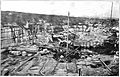
Beaver Dam Quarry in 1898

See also
 In Spanish: Cockeysville (Maryland) para niños
