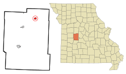
Cole Camp, Missouri facts for kids
Quick facts for kids
Cole Camp, Missouri
|
|
|---|---|

Location of Cole Camp, Missouri
|
|
| Country | United States |
| State | Missouri |
| County | Benton |
| Area | |
| • Total | 1.30 sq mi (3.37 km2) |
| • Land | 1.30 sq mi (3.37 km2) |
| • Water | 0.00 sq mi (0.00 km2) |
| Elevation | 1,053 ft (321 m) |
| Population
(2010)
|
|
| • Total | 1,121 |
| • Estimate
(2019)
|
1,134 |
| • Density | 870.97/sq mi (336.37/km2) |
| Time zone | UTC-6 (Central (CST)) |
| • Summer (DST) | UTC-5 (CDT) |
| ZIP code |
65325
|
| Area code(s) | 660 |
| FIPS code | 29-15436 |
| GNIS feature ID | 0716089 |
Cole Camp is a small city in Benton County, Missouri, United States. The population was 1,121 at the 2010 census.
The town is known for the annual street fair in September. It also hosts a Maifest in May, an Oktoberfest in October, and a Christbaumfest in late November; all highlight the town's German heritage.
History
Cole Camp was laid out in 1857. The city most likely was named after pioneer Captain Stephen Cole.
Cole Camp was the site of a skirmish early in the American Civil War, when the local pro-Union Home Guard company was attacked by a Missouri State Guard force on June 19, 1861. At this battle of Cole Camp, the Home Guard were defeated with a loss of 35 men killed or wounded.
The Central Cole Camp Historic District and Augustus Sander House are listed on the National Register of Historic Places.
Geography
Cole Camp is located at 38°27′34″N 93°12′16″W / 38.45944°N 93.20444°W (38.459489, -93.204398).
According to the United States Census Bureau, the city has a total area of 1.30 square miles (3.37 km2), all of it land.
Demographics
| Historical population | |||
|---|---|---|---|
| Census | Pop. | %± | |
| 1900 | 648 | — | |
| 1910 | 910 | 40.4% | |
| 1920 | 889 | −2.3% | |
| 1930 | 932 | 4.8% | |
| 1940 | 753 | −19.2% | |
| 1950 | 813 | 8.0% | |
| 1960 | 853 | 4.9% | |
| 1970 | 1,038 | 21.7% | |
| 1980 | 1,022 | −1.5% | |
| 1990 | 1,054 | 3.1% | |
| 2000 | 1,028 | −2.5% | |
| 2010 | 1,121 | 9.0% | |
| 2019 (est.) | 1,134 | 1.2% | |
| U.S. Decennial Census | |||
2010 census
As of the census of 2010, there were 1,121 people, 492 households, and 286 families residing in the city. The population density was 862.3 inhabitants per square mile (332.9/km2). There were 560 housing units at an average density of 430.8 per square mile (166.3/km2). The racial makeup of the city was 98.2% White, 0.1% Native American, 0.3% Asian, 0.3% from other races, and 1.2% from two or more races. Hispanic or Latino of any race were 0.9% of the population.
There were 492 households, of which 27.0% had children under the age of 18 living with them, 45.1% were married couples living together, 10.0% had a female householder with no husband present, 3.0% had a male householder with no wife present, and 41.9% were non-families. 38.0% of all households were made up of individuals, and 26.2% had someone living alone who was 65 years of age or older. The average household size was 2.16 and the average family size was 2.85.
The median age in the city was 47.3 years. 21.6% of residents were under the age of 18; 7.1% were between the ages of 18 and 24; 18.2% were from 25 to 44; 23.5% were from 45 to 64; and 29.5% were 65 years of age or older. The gender makeup of the city was 44.7% male and 55.3% female.
Education
Cole Camp R-1 School District operates one public elementary school, one middle school, and Cole Camp High School. Cole Camp Methodist Pre-School and Trinity Lutheran Pre-School are private institutions.
Cole Camp has a public library, a branch of the Boonslick Regional Library.
Notable people
- Matt Bohon - bull rider on the PBR's Built Ford Tough Series
- Martin Heinrich, raised in Cole Camp. Former congressman and U.S. Senator from New Mexico
- Stan Kroenke- owner of Los Angeles Rams, Denver Nuggets, Colorado Avalanche, and majority owner of Arsenal
See also
 In Spanish: Cole Camp (Misuri) para niños

