
Coleraine facts for kids
Quick facts for kids Coleraine
|
|
|---|---|
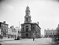
 Coleraine Town Hall |
|
 OpenStreetMap of Coleraine |
|

|
|
| Population | 24,634 |
| Irish grid reference | C844328 |
| District |
|
| County | |
| Country | Northern Ireland |
| Sovereign state | United Kingdom |
| Post town | COLERAINE |
| Postcode district | BT51, BT52 |
| Dialling code | 028 |
| Police | Northern Ireland |
| Fire | Northern Ireland |
| Ambulance | Northern Ireland |
| EU Parliament | Northern Ireland |
| UK Parliament |
|
| NI Assembly |
|
Coleraine ( KOHL-rayn; from Irish: Cúil Rathain 'nook of the ferns') is a town and civil parish near the mouth of the River Bann in County Londonderry, Northern Ireland. It is 55 miles (88.5 km) northwest of Belfast and 30 miles (48.3 km) east of Derry, both of which are linked by major roads and railway connections. It is part of Causeway Coast and Glens district.
Contents
Description
Coleraine had a population of 24,630 people in the 2011 Census. Disposable income is well above the Northern Ireland average. The North Coast (Coleraine and Limavady) area has the highest property prices in Northern Ireland, higher even than those of affluent South Belfast. Golf courses, countryside and leisure facilities and attractions are to be found. It has an attractive town centre, and a marina. Coleraine during the day is a busy town, however at night the town is relatively quiet, with much of the nightlife in the area located in the nearby seaside towns of Portrush and Portstewart. Coleraine is also home to the one of the largest Polish communities in Northern Ireland.
Coleraine is situated at the lowest bridgeable point of the River Bann, where the river is 90 metres wide. The town square is called 'The Diamond' and is the location of the Town Hall. St. Patrick's Church of Ireland is situated nearby. The University of Ulster campus was built in the 1960s and has brought a theatrical space to the town in the form of the Riverside Theatre.
Coleraine has been designated as a major growth area in the Northern Ireland Development Strategy. Although the population of the town is only 25,000, Coleraine has a large catchment area. The town also has the advantage of being near some of the most extraordinary landscape in the whole of Europe. In 2002, Coleraine won the Best Kept Town and Ulster in Bloom awards. In 2003, it was selected to represent Northern Ireland in the prestigious Britain in Bloom competition. In the 2010 SuperValu Best Kept Awards, Coleraine was named the Best Kept Large Town in Northern Ireland, this is a prestigious award which commends towns throughout Northern Ireland for their work to improve the local environment. It has its own local radio station: Q97.2FM
History

Coleraine has a long history of settlement. The Mesolithic site at Mount Sandel, which dates from approximately 5935 BC is some of the earliest evidence of human settlement in Ireland.
The Tripartite Life of Saint Patrick records how the town got its name. When Patrick arrived in the neighbourhood, he was received with great honour and hospitality by the local chieftain, Nadslua, who offered him a piece of ground on which to build a church. The spot was next to the river Bann and was overgrown with ferns, which were being burned by some boys to amuse themselves. This incident led to the area being called Cúil Raithin ("nook of ferns"), which was later anglicised as Colrain, Colerain and Coleraine. It was translated by Colgan into Latin as Secessus Filicis.
The town was one of the two urban communities developed by the London Companies in County Londonderry in the Plantation of Ulster at the start of the 17th century. The slightly skewed street pattern of Coleraine's town centre is legacy of that early exercise in town planning, along with traces of the lines of the ramparts that provided the Plantation town with its defences. In 1637 the Surveyor General of Customs issued a report compiled from accounts of customs due from each port and their "subsidiary creeks". Of the Ulster ports on the list, Carrickfergus was first, followed by Bangor, Donaghadee, and Strangford. Carlingford and Coleraine each had £244 customs due and had equal ranking.
During the War of the Two Kings (1689–91) Coleraine was a centre of Protestant resistance to the rule of James II. Richard Hamilton's Irish Army made an attempt to seize the town, but were repulsed. The Protestants were forced to abandon the town shortly afterwards and withdrew to Derry. Later the same year, following the failed Siege of Derry, Sir Charles Carney and his Jacobite garrison fled the town on receiving news of the advance of Percy Kirke's Enniskillen forces and the landing at Carrickfergus of Marshal Schomberg. The Williamites controlled Coleraine for the remainder of the war.
With some industrialisation, the expansion of the river port, and the development of the railway, the town expanded significantly throughout the 19th century and into the early part of the 20th century. Coleraine steadily expanded after the Second World War. The population doubled due to major industrial development on extensive suburban sites, the decision to site the New University of Ulster (now known as the Ulster University) in the town, the expansion of commerce and the development of sporting and recreational facilities. There has been a steady expansion of the urban area from the mid 20th century compact town of less than 1¼ square miles (2 km²), to the present much more dispersed town of about 7 square miles (11 km²). During the Northern Irish Troubles 13 people were killed in or near Coleraine, ten of them in two separate car bomb explosions.
Since 1980 growth has continued but at a slightly more modest pace. In the twenty years to 2001 the town's population increased by 22% to approximately 25,000 but the rate of increase fell from 12% in the 1980s to 8% in the 1990s.
The Troubles
Tourism
Coleraine is the main town of the world famous Causeway Coast, which attracts over three million visitors per year, spending in excess of £47 million. The world famous Giant's Causeway is a twenty–five-minute bus ride away. The distillery village of Bushmills is well-served by buses from the town and there is a narrow-gauge steam train running in the summer from Bushmills to the Giant's Causeway. The train journey takes approximately fifteen minutes from the town to the Causeway. Also north of Coleraine is the scenic coastal town of Portstewart, with fine sandy beach and coastal walks. Portrush is part of the Borough.
North-west of Coleraine lies the small village of Castlerock, with a beach which is essentially a continuation of the beach at Portstewart, separated by the River Bann. Also nearby is the huge beach at Benone Strand and Mussenden Temple, built by Frederick Augustus Hervey, an 18th-century Anglican bishop atop a precipitate cliff and overlooking County Donegal in one direction and Scotland in another. The National Trust managed Downhill forest was part of the Bishop's Palace, and although the Palace itself is now a ruin the gardens are a wonderful place full of strange hidden lakes and gloriously tended flower gardens.
Climate
As with the rest of the British Isles, Coleraine experiences a maritime climate with cool summers and mild to cold winters. The nearest official Met Office weather station for which online records are available is at nearby Coleraine university, about 1 mile North of the town centre. However, observations ceased a few years ago and the nearest current Met Office weather observing station is at Movanagher, about 12 miles to the south. Rainfall at Coleraine typically peaks at over 100mm during the month of October. The driest month is May, with an average of under 60mm. On average, 173 days of the year will report at least 1mm of rain, ranging from 18 days in January to 11 days during June.
| Climate data for Coleraine University, 1971–2000 23m asl (Weather station 1 mile (2 km) to the North of Coleraine town centre) | |||||||||||||
|---|---|---|---|---|---|---|---|---|---|---|---|---|---|
| Month | Jan | Feb | Mar | Apr | May | Jun | Jul | Aug | Sep | Oct | Nov | Dec | Year |
| Average high °C (°F) | 6.3 (43.3) |
7.0 (44.6) |
9.1 (48.4) |
11.9 (53.4) |
15.0 (59.0) |
16.9 (62.4) |
18.0 (64.4) |
17.8 (64.0) |
16.3 (61.3) |
12.9 (55.2) |
9.8 (49.6) |
7.1 (44.8) |
12.3 (54.2) |
| Average low °C (°F) | 1.2 (34.2) |
1.6 (34.9) |
2.8 (37.0) |
3.9 (39.0) |
6.0 (42.8) |
9.6 (49.3) |
11.0 (51.8) |
10.7 (51.3) |
8.8 (47.8) |
6.7 (44.1) |
3.7 (38.7) |
1.8 (35.2) |
5.6 (42.2) |
| Source: YR.NO | |||||||||||||
Places of interest
The east side of the town is distinguished by Mountsandel Forest, which contains the Mount Sandel fort, an ancient site which has been claimed as the oldest site of human settlement in Ireland. Here wooden houses dating from about 7000 BC were uncovered. The fort can be accessed via Mountsandel forest, the closest entrance being the side near the Coleraine Courthouse. There is another fort about 2 miles south from Mountsandel one near a small village called the Loughan.
Transport
Coleraine railway station opened on 4 December 1855 and shares facilities with the town's Ulsterbus bus depot. Passenger service is delivered via the Belfast-Derry railway line along the scenic shore of Lough Foyle and the Coleraine-Portrush railway line branch line. The Belfast-Derry railway line is to be upgraded to facilitate more frequent trains and improvements to the permanent way such as track and signalling to enable faster services.
The railway station was closed for goods traffic on 4 January 1965.
2011 Census
Coleraine is classified as a large town (i.e. with population between 18,000 and 75,000 people). On Census day (27 March 2011) there were 59,069 people living in Coleraine Borough (this number includes the other towns and villages in the borough). Of these:
- 22.3% were aged under 16 years and 16.7% were aged 65 and over
- 47.7% of the population were male and 52.3% were female
- 28% belong to or were brought up in the Catholic denomination and 65.3% belong to or were brought up in a Protestant and Other Christian (including Christian related) denominations.
- 3.9% of people aged 16–74 were unemployed.
Coleraine internationally
Coleraine, as a town name, exists in other countries, for example Coleraine in Minnesota, United States. In 1853, a surveyor named Lindsay Clarke was working on a township called Bryans Creek Crossing in Victoria, Australia. He renamed the town Coleraine.
A wine from New Zealand, Te Mata Estate's Coleraine Cabernet/Merlot, is named after the town.
The Zomba Action Project is a charity founded in 2003 under the guidance of Coleraine Borough Council to aid the municipality of Zomba in southern Malawi, which aims to help some of the citizens of that region to build a better life for themselves and their children. The region was chosen due to the historical connections between the Presbyterian and Catholic churches and Malawi, sustained by a number of specific local contacts. Donations have been used to fund computers, education, medical and other projects.
A street in the Pointe-Saint-Charles neighbourhood of Montreal, Canada is named Coleraine, which once was an Irish neighbourhood.
Saint-Joseph-de-Coleraine, a small municipality in the Appalachian Mountains region of the province of Quebec, Canada, is named after Saint Joseph, father of Jesus, and, the town of Coleraine in County Londonderry, Northern Ireland. It is part of the "Chaudière-Appalaches" region and the population is 2,018 as of 2009. It holds an Irish Heritage Festival annually.
Coleraine is twinned with French town La Roche-sur-Yon.
Demography
Coleraine is classified as a large town (i.e. with population between 18,000 and 75,000 people).
2011 Census
On Census day (27 March 2011) there were 24,634 people living in Coleraine, accounting for 1.36% of the NI total. Of these:
- 19.91% were aged under 16 years and 14.89% were aged 65 and over;
- 52.16% of the usually resident population were female and 47.84% were male;
- 68.08% belong to or were brought up in a 'Protestant and Other Christian (including Christian related)' denominations and 24.09% belong to or were brought up in the Catholic Christian faith;
- 66.16% indicated that they had a British national identity, 31.52% had a Northern Irish national identity and 10.19% had an Irish national identity (respondents could indicate more than one national identity);
- 38 years was the average (median) age of the population.
- 13.67% had some knowledge of Ulster-Scots and 4.77% had some knowledge of Irish (Gaelic).
Sport
Coleraine itself contains Coleraine Rugby Club, established in 1921, Coleraine F.C., established in 1927 and currently in the IFA Premiership and CLG Eoghan Rua established in 1957. Coleraine is one of the hosting towns for the Milk Cup.
Coleraine is part of the circuit for the North West 200, a series of motorcycle road races organised by the Coleraine and District Motor Club.
Coleraine Bowling Club is a lawn bowls club on the Lodge Road and was founded in 1903. Coleraine is one of the most successful teams in the NIPBA and Irish bowling, with 64 titles on the honours list. The Bannsiders have claimed two Irish Bowling Association Senior Challenge Cup victories, in 1921 and 2013. Coleraine have also provided a number of international players and Commonwealth Games representatives, most notably Victor Dallas and Roy Fulton.
Coleraine Cricket Club plays in the North West Senior League.
In the wider local area are a number of well-known golf courses, including Castlerock Golf Club, Royal Portrush Golf Club and Portstewart Golf Club.
The Coleraine area has a significant equestrian presence. Of particular interest is RDA Coleraine (Riding for the Disabled Association (Coleraine & District Group), which provides riding opportunities for anyone with a physical and/or learning disability at their £1.75 million RDA Causeway Coast Arena at Castleroe (see website www.rdacoleraine.org). The new arena was funded by SportNI, Coleraine Borough Council, and by donations from the people of the district. The conditions of grant aid included the provision of a first-class sporting arena for RDA, the equestrian fraternity, and other sporting activities. Especially important is the development of The OWLS Sports Club (Opportunities Without Limits), which will co-ordinate the development of a range of different sporting opportunities for persons with physical and/or learning disabilities, and in many cases their siblings. To facilitate this process SportNI has funded a Sports Development Officer.
Education
Coleraine has a variety of educational institutions at all levels.
Primary and secondary schools
The local schools include:
- Saint John's Primary School
- Irish Society's Primary School
- Coleraine Grammar School
- Coleraine College
- St Joseph's College, Coleraine
- D.H Christie Memorial Primary School
- Killowen Primary School
- Loreto College, Coleraine (a co-educational Roman Catholic grammar school)
- Harpurs Hill Primary School
- Millburn Primary School
- Saint Malachy's Primary School
- North Coast Integrated College
- Macosquin Primary School
- Sandelford Special School
- Ballysally Primary School
Tertiary
Coleraine is the location of a University of Ulster campus and houses the university's administration buildings. It is the original campus of what was the New University of Ulster (established in 1968) which merged with the former Ulster Polytechnic at Jordanstown just north of Belfast in 1984 to form the present-day institution. The university was placed in the top five of UK universities by the 2014 Research Excellence Framework for its law, biomedical, and humanities programs. The Causeway Institute is a College of Further and Higher Education based in Coleraine, with another campus in nearby Ballymoney.
Notable people
Living people
- Richard Archibald – rower
- John Baxter – politician, lawyer
- Alan Campbell – rower
- Joel Cassells — rower
- Peter Chambers – rower
- Richard Chambers – rower
- Jack Doherty – potter
- Michelle Fairley – actress
- Maureen Madill – golfer, coach and broadcaster
- Jenna McCorkell – British ladies' figure skating champion
- Gerry McKenna – biologist and university administrator
- James Nesbitt – actor
- Maggie O'Farrell – novelist
- Damien O'Kane – folk singer
- Tommy Sheppard – Scottish politician
- Claire Sugden – politician
- Andrew Trimble – rugby union player
- Bronagh Waugh – actress
- Jayne Wisener – actress
Historical figures
- Alexander Anderson – physicist
- Lewis Thomas Drummond – lawyer, judge, political figure
- Harry Gregg MBE – goalkeeper
- Sam Henry – civil servant, antiquarian, lecturer, writer, photographer, folklorist, and folk-song collector
- Sir Thomas Ranken Lyle – mathematical physicist
- Patrick McGilligan – politician
- Hercules Mulligan – tailor and spy during the American Revolutionary War
- Edward Nicolls – Royal Marines officer
- Bertie Peacock – footballer
- Isaac Todd – merchant
- Charles Frederick Williams – journalist and war correspondent
Images for kids
-
Coleraine c.1890
.jpg)
See also
 In Spanish: Coleraine para niños
