Colfax, Indiana facts for kids
Quick facts for kids
Colfax, Indiana
|
|
|---|---|

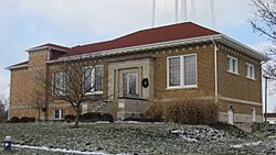
The Colfax Carnegie Library
|
|

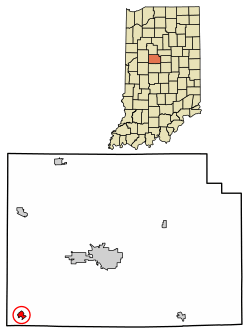
Location of Colfax in Clinton County, Indiana.
|
|
| Country | United States |
| State | Indiana |
| County | Clinton |
| Township | Perry |
| Founded | 1849 |
| Named for | Schuyler Colfax |
| Area | |
| • Total | 0.37 sq mi (0.96 km2) |
| • Land | 0.37 sq mi (0.96 km2) |
| • Water | 0.00 sq mi (0.00 km2) |
| Elevation | 840 ft (256 m) |
| Population
(2020)
|
|
| • Total | 702 |
| • Density | 1,897.30/sq mi (733.11/km2) |
| Time zone | UTC-5 (EST) |
| • Summer (DST) | UTC-5 (EST) |
| ZIP code |
46035
|
| Area code(s) | 765 |
| FIPS code | 18-14284 |
| GNIS feature ID | 0432758 |
Colfax is a town in Perry Township, Clinton County, Indiana, United States. The population was 691 at the 2010 census. The town was originally known as Midway since it was a half-way point on the IC&L Railroad between Chicago & Louisville. Railways intersected North/South & East/West making Colfax a popular transfer destination. The town was renamed to honor Vice President Schuyler Colfax in 1857.
Contents
History
Colfax was laid out in 1849 by Montgomery Stroud and originally named Midway for its position between Indianapolis and Lafayette along the Lafayette railroad. In 1853 the town gained a post office named Colfax, and in December 1857 the name of the town itself became Colfax, by petition of the residents. By 1861 the town had two churches, two general stores, a hotel, a saw mill and approximately 200 residents.
An incorporation election held December 25, 1869, resulted in 24 yeas and 1 no. The town had 187 residents in 1870, but with the construction of the Vandalia road through town in 1870-71 it grew quickly and by 1880 had a population of 638.
The Colfax Carnegie Library and Rosenberger Building are listed on the National Register of Historic Places.
Geography
Colfax is located at 40°11′38″N 86°40′5″W / 40.19389°N 86.66806°W (40.193788, -86.668085).
According to the 2010 census, Colfax has a total area of 0.36 square miles (0.93 km2), all land.
Demographics
| Historical population | |||
|---|---|---|---|
| Census | Pop. | %± | |
| 1870 | 187 | — | |
| 1880 | 638 | 241.2% | |
| 1890 | 730 | 14.4% | |
| 1900 | 767 | 5.1% | |
| 1910 | 801 | 4.4% | |
| 1920 | 793 | −1.0% | |
| 1930 | 690 | −13.0% | |
| 1940 | 717 | 3.9% | |
| 1950 | 725 | 1.1% | |
| 1960 | 725 | 0.0% | |
| 1970 | 633 | −12.7% | |
| 1980 | 823 | 30.0% | |
| 1990 | 727 | −11.7% | |
| 2000 | 768 | 5.6% | |
| 2010 | 691 | −10.0% | |
| 2020 | 702 | 1.6% | |
| U.S. Decennial Census | |||
2010 census
As of the census of 2010, there were 691 people, 268 households, and 194 families living in the town. The population density was 1,919.4 inhabitants per square mile (741.1/km2). There were 322 housing units at an average density of 894.4 per square mile (345.3/km2). The racial makeup of the town was 96.1% White, 0.4% African American, 0.7% Asian, 0.3% from other races, and 2.5% from two or more races. Hispanic or Latino of any race were 3.2% of the population.
There were 268 households, of which 37.3% had children under the age of 18 living with them, 53.7% were married couples living together, 12.3% had a female householder with no husband present, 6.3% had a male householder with no wife present, and 27.6% were non-families. 23.5% of all households were made up of individuals, and 10.1% had someone living alone who was 65 years of age or older. The average household size was 2.58 and the average family size was 3.01.
The median age in the town was 40.1 years. 25.2% of residents were under the age of 18; 7.9% were between the ages of 18 and 24; 25.1% were from 25 to 44; 26.6% were from 45 to 64; and 15.2% were 65 years of age or older. The gender makeup of the town was 47.2% male and 52.8% female.
Education
The town has a free lending library, the Colfax-Perry Township Public Library.
See also
 In Spanish: Colfax (Indiana) para niños

