
Columbia, Alabama facts for kids
Quick facts for kids
Columbia, Alabama
|
|
|---|---|

Columbia, Alabama in 2012
|
|

Location of Columbia in Houston County, Alabama.
|
|
| Country | United States |
| State | Alabama |
| County | Houston |
| Area | |
| • Total | 4.00 sq mi (10.35 km2) |
| • Land | 3.93 sq mi (10.18 km2) |
| • Water | 0.07 sq mi (0.17 km2) |
| Elevation | 223 ft (68 m) |
| Population
(2020)
|
|
| • Total | 690 |
| • Density | 175.53/sq mi (67.77/km2) |
| Time zone | UTC-6 (Central (CST)) |
| • Summer (DST) | UTC-5 (CDT) |
| ZIP code |
36319
|
| Area code(s) | 334 |
| FIPS code | 01-16744 |
| GNIS feature ID | 0116457 |
Columbia is a town in Houston County, Alabama, United States. It is part of the Dothan, Alabama Metropolitan Statistical Area. At the 2010 census the population was 740, down from 804 in 2000.
Contents
History
Founded in 1820, Columbia served as a major trading center for communities throughout the Wiregrass Region of Alabama between 1822-1833, which coincided as its time as Henry County seat. Henry County which then comprised portions of present-day Covington, Dale, Barbour, Coffee, Crenshaw, Bullock, Geneva, and Houston counties. It lost the county seat status to Abbeville in 1833.
Bordering the State of Georgia and the Chattahoochee River, Columbia was a major port-of-call for steamboats and was known to many as "Old Columbia". The town was incorporated on April 29, 1880 and was the center of education, culture, commerce, and trade. Columbia was the largest town in the area during the 19th century and remains one of the area's oldest continuously operating municipalities.
Columbia received its first cotton textile mill in 1891 and its first electric plant in 1892. A branch of the Henry County Courthouse was located here from 1889 until Columbia became part of Houston County in 1903. Columbia got electric street lights in 1900 and its first electric utility company in 1914.
At the turn of the 20th century, Columbia was bypassed by the Alabama Midland Railway in favor of Dothan. As the railroads continued to take freight trade away from the riverboats. Columbia's position as a principal trade center began to decline; however, Columbia sustained itself as a thriving farming community through the mid-20th century.
Old Columbia Jail
Erected sometime in the early 1860s, the Old Columbia Jail is today one of the last wooden jails still standing in Alabama. Originally, there were two cells, each measuring 10x15 feet. Interior walls are studded every two inches with iron spikes to prevent prisoners from being able to escape. The Columbia Women's Club and the Columbia Bicentennial Committee have completely renovated the building for use as a museum to preserve some of the articles of historical interest to Columbia citizens.
Purcell-Killingsworth House
The Purcell-Killingsworth House, also known as "Traveler's Rest" was completed in 1890 by William Henry Purcell (1845–1910), a prominent Columbia business man and politician. Purcell had many business interests including a steamboat landing on the Chattahoochee River. This was the boyhood home of Bishop Clare Purcell (1884–1964) who, in 1955, was elected President of the United Methodist Council of Bishops, the highest place of recognition ever achieved by a native-born Alabama Methodist minister. In 1946, the Purcell Family sold the two acre homestead to Mr. & Mrs. Henry Killingsworth who have meticulously restored this imposing Victorian mansion. It was placed on the National Register of Historic Places on December 16, 1982.
Geography
Columbia is located at 31°17′32″N 85°06′44″W / 31.292283°N 85.112123°W. According to the U.S. Census Bureau, the town has a total area of 4.0 square miles (10 km2), of which 3.9 square miles (10 km2) is land and 0.1 square miles (0.26 km2) (1.75%) is water.
Demographics
| Historical population | |||
|---|---|---|---|
| Census | Pop. | %± | |
| 1880 | 290 | — | |
| 1890 | 960 | 231.0% | |
| 1900 | 1,132 | 17.9% | |
| 1910 | 1,122 | −0.9% | |
| 1920 | 860 | −23.4% | |
| 1930 | 926 | 7.7% | |
| 1940 | 829 | −10.5% | |
| 1950 | 849 | 2.4% | |
| 1960 | 783 | −7.8% | |
| 1970 | 891 | 13.8% | |
| 1980 | 881 | −1.1% | |
| 1990 | 922 | 4.7% | |
| 2000 | 804 | −12.8% | |
| 2010 | 740 | −8.0% | |
| 2020 | 690 | −6.8% | |
| U.S. Decennial Census 2013 Estimate |
|||
2020 census
| Race | Num. | Perc. |
|---|---|---|
| White (non-Hispanic) | 529 | 76.67% |
| Black or African American (non-Hispanic) | 117 | 16.96% |
| Asian | 1 | 0.14% |
| Other/Mixed | 40 | 5.8% |
| Hispanic or Latino | 3 | 0.43% |
As of the 2020 United States census, there were 690 people, 343 households, and 192 families residing in the town.
Gallery
-
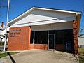
Columbia Post Office (ZIP code: 36319)
-
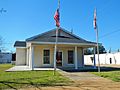
Rossie Purcell Public Library
-
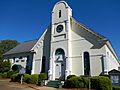
Columbia First Baptist Church
-
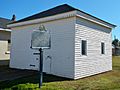
The Old Columbia Jail
-
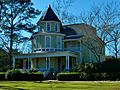
The Purcell-Killingsworth House
-
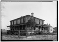
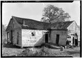
S. M. Dunwoody House. Taken as part of the Historic American Buildings Survey (HABS)
-
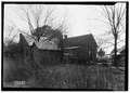
Tom Bowden House. Taken as part of the HABS
-
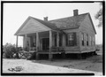
J. B. Taylor House. Taken as part of the HABS
-
Teague-Regell House. Taken as part of the HABS


Notable people
- Dave Edwards, former Auburn University and Dallas Cowboys player
- Monte Irvin, born in Columbia, member of the Baseball Hall of Fame
- B'Ho Kirkland, born in Columbia, played for the Alabama Crimson Tide and went on to play for the Brooklyn Dodgers (NFL).
- Clare Purcell, born in Columbia, American Bishop of the Methodist Episcopal Church, South and the Methodist Church, elected in 1938.
See also
 In Spanish: Columbia (Alabama) para niños
