
Concow, California facts for kids
Quick facts for kids
Concow, California
|
|
|---|---|

Location in Butte County and the state of California
|
|

Concow, California
Location in the United States
|
|
| Country | |
| State | |
| County | Butte |
| Area | |
| • Total | 27.78 sq mi (71.95 km2) |
| • Land | 27.41 sq mi (70.98 km2) |
| • Water | 0.37 sq mi (0.97 km2) 1.35% |
| Elevation | 2,005 ft (611 m) |
| Population
(2020)
|
|
| • Total | 402 |
| • Density | 14.67/sq mi (5.66/km2) |
| Time zone | UTC−08:00 (Pacific) |
| • Summer (DST) | UTC−07:00 (PDT) |
| ZIP Code |
95965
|
| Area code | 530 |
| FIPS code | 06-16035 |
| GNIS feature IDs | 1867007, 2407652 |
Concow (Konkow: Koyoom Kʼawi, meaning "Meadow") is an unincorporated community and census-designated place (CDP) in the Sierra Nevada foothills covering eastern Butte County, California. Due to a decline in employment and repeated wildfires, over the past hundred years the population declined from several thousand to several dozen. On November 8, 2018, a wildfire, the Camp Fire, destroyed most of Concow, as well as the adjacent municipality of Paradise.
Concow is named after the Native American tribe that is indigenous to the area, the Concow Maidu. The original inhabitants ate salmon from the Feather River, acorns and pine nuts, venison, nō-kōm-hē-i'-nē, and other sources of food which abounded in the California foothills.
Contents
History
"In the beginning Wahno-no-pem, the Great Spirit, made all things. Before he came, everything on the earth and in the skies was hidden in darkness and in gloom, but where he appeared he was the light. From his essence, out of his breath, he made the sun, the moon, and the countless stars, and pinned them in the blue vault of the heavens."
Colonization
There is no indication that there was external governance of the Concow region or the tribal peoples that inhabited the region during the 1697–1821 Spanish colonization or the 1821–1846 Mexican era, characterized by the spread of Californio slave ranchos. The Concow region is 20 miles north of the city of Oroville (an Anglo-Hispanic compound meaning 'gold-town') and about the same distance east of the town of Chico; named for Rancho Arroyo Chico—meaning 'little creek ranch.' Rancho Arroyo Chico was established through a land-grant from the Mexican authorities in 1844, two years before California was invaded by United States forces, an indication that there was some Mexican governance near the Concow region, but no indication of governance of the region.
Discovery
Aside from governance, starting in 1828, northern trappers including Jedediah Smith, Michel Laframboise, and John Work first made contact with the Concow region Maidu. In 1851 the Beckwourth_Trail established the first transportation route to the Concow region. The route did not pass directly through the present day Concow, the trail followed a series of ridgtops 10 miles to the East. Soon began death from diseases, such as pneumonia and malaria, that the Maidu have no natural immunity. In addition to disease, in 1853, under the leadership of Gov. Bigler, several municipalities within the State of California ordered all non-European people of California - including the Maidu - exterminated in return for a cash bounty of $5.00 ($134.95 in 2010 US$) per person. In addition to the municipal bounty system, through funding numerous militia attacks on the native people, the resulting debt became known as the "California War Debt" or "Army Appropriations Bill". In 1854 - though not entirely clear why - Secretary of War Jefferson Davis wrote California that their 'war' expenditures could not be authorized without the original bills of sale to verify the purpose was one intended by congress. The bill of sale for the bounty was the head. California was reimbursed $924,259.65 ($23.4M 2010US) by the United States Federal Government and again reimbursed $229,981.67 in 1861 for the intervening years. Assuming the $1.2M the State of California claimed in expenses for the 'War' was used entirely for $5 bounties, then this represents the death of 240,000 California natives; during that same time period the native population declined from 250,000 to less than 50,000, a comparable amount. Their fictionalized but true in spirit story is told by the real person Ishi, who may have been part or full Maidu. Ishi was from the Concow region.
Settlement
Permanent settlements soon followed and by 1856 several were well established. The growth of these settlements increased after Charles Curtis constructed a toll bridge (1858) across the Feather River at Nelson's Bar and the next year (1859) an additional bridge was constructed by residents of Whiskey Town over the Feather River just North of the Concow region. Basically, there was a Northernly trail and bridge from present day Oroville, and a Southernly trail and bridge from present day Magalia.
Clearances
After a decade of genocide and forcible removals, in 1859 the last of the Kon Kow peoples were forcibly removed by Tehama County ranchers as part of a larger four county 'roundup.' They were held at the Mendocino Reservation until the California Reservation Administration at the camp collapsed due to lack of funding due to the Civil War occurring on the East Coast. The Kon Kow were then deported to the Nome Cult Farms at the Round Valley reservation. By 1862 the last of the native Concow inhabitants were starving on the cramped Round Valley with unrelated people relocated from surrounding regions. The damp coastal climate on the reservation contrasts with the dry climate of the California 'Gold Country' they are accustomed to. It was the midst of the North American Civil War and federal funds for California Reservations were no longer arriving. In the cooling weather of late September, on September 24, 1862, a combination of the poor camp conditions, forced participation in a massacre of the local Wailaki peoples, warnings by local whites that they were planning to massacre the reservation inhabitants that winter, and an imminent winter disaster under the supervision of indian agent James Short forced a group of over 400 men, women, children, and elderly to set out with Tome-ya-nem, without provisions, for the 130 miles back to their home in the Concow Valley: a 10-day hike for well equipped healthy young adults. They made it as far as present day Chico where Agent Hanson had made an agreement with John Bidwell to stop and encamp the Kon Kow people at Bidwell's old river landing - now under Lake Oroville - under the supervision of Sub Agent Eddy and employed for $.10 per hour ($2.72 2013US) constructing the Chico-Humboldt road and providing labor for various employers in the area.
The End
After consulting with Superintendent Hanson and superiors Colonel Richard Cloyd Drum and General George Wright, Captain Starr was ordered by General Wright in Post Order No. 6 to lead 23 soldiers of Company F 2nd Regiment California Volunteer Cavalry and move the now imprisoned people the 110 miles from Camp Bidwell back to Round Valley on the Nome Cult Trail on what became a 20-day forced death march now remembered as the KonKow Trail of Tears. Despite efforts by the soldiers and the Pence resolution mandated donations of food and shelter provisions, horses and wagons, each day those who could not make the march through the hot arid early September Sacramento Valley - where afternoon temperatures top 90 °F or over the 6,000 foot crest of the North Coast Ranges - were left behind without food or water.
Relics of Maidu
The current inhabitants of Concow, including a few Maidus, commonly find relics of the Maidu in the form of beads and stone tools while digging in and around their homes. In the Concow Lake Valley there is no monument, plaque, or other recognition to memorialize the fate of the KonKow people - few if any of the current inhabitants know.
The Commune Era
While a post office operated at Concow from 1882 to 1906, renamed from Con Cow to Concow in 1895, and relocated several times, the region was sparsely populated and dominated by a few ranching families. The economy of the region rose and fell with the gold rush need for supplies, the civil war demand for pine turpentine, logging, and the water way that allowed for ranching. The economy ebbed and flowed for a hundred years under the constraint of the difficult access to the region.
In 1962 a new 4-lane alignment of California State Route 70 wrapped around the western side of the then proposed Lake Oroville and reconnected with the existing highway 70 at Jarbo Gap. The realignment placed a major throughway to the Concow region, opening the area for residential purposes and made it easier for adherents to the then blossoming 'land movement' to find inexpensive land in an undeveloped region, within commuting distance of a large metropolitan region. From this point to 2008, Concow become a haven for those escaping 'the world.' Unpermitted structures constructed with commune labor and primitive or re-purposed materials dotted the landscape and housed an eclectic community for the next 50 years.
In 2008 a 60,000 acre (large fire) wildfire destroyed 250 structures, of those 220 were unpermitted and either were not built to building codes, did not bother with building inspections, or did not use approved building materials. Due to the 'land' nature of the community, affording construction following building codes was not possible initially and reconstruction to building codes is not possible or within the 'ethos' of the community. The county offered special waivers for reconstruction, but the community was already gutted, those who remain are a shadow of the community. Filling this void is a wave of retiring baby boomers and young couples following a current 'land movement' based on contemporary ideals but still following the core of previous movements.
Geography
According to the United States Census Bureau, the CDP has a total area of 27.78 square miles (71.9 km2), of which, 27.41 square miles (71.0 km2) of it is land and 0.37 square miles (0.96 km2) of it (1.35%) is water.
For unknown reasons the community's name was absent from the US Geological Survey files until 1990. Other nearby communities are The Pines (USGS feature ID 268203), and Deadwood (USGS feature ID 1655957). The community is off State Route 70 east of Cherokee. Concow School is shown on some maps. There is a Concow Dam, Road, and Creek nearby.
Demographics
| Historical population | |||
|---|---|---|---|
| Census | Pop. | %± | |
| 1990 | 1,392 | — | |
| 2000 | 1,095 | −21.3% | |
| 2010 | 710 | −35.2% | |
| 2020 | 402 | −43.4% | |
| U.S. Decennial Census | |||
The first census of the Concow region was in 1990. At first contact with native peoples in Concow the population was over 1,000, however, it was noted that the population had been higher and the people were sick with cholera. The 1850 and 1860 populations are largely the Concow people which declined due to massacre and deportation.
2000
The 2000 census counted 1,095 people in 571 housing units and forming 319 families. The population density was 29 people per square mile (11.2/km2), and a housing density of 15 per square mile (5.9/km2). Of households, 24 percent included children under the age of 18; half were married couples, 8 percent had a female head of household, and 30 percent were non-families; 23 percent were individuals, and of those a third were over 65 years old. The median family income was $41,250, and the per capita income was $15,829. That placed 27 percent of those under age 18 and 14 percent of the population below the poverty line. The racial makeup was 91 percent White. As individuals, there were, 10 African Americans, 25 Native Americans, and 52 Latinos.
2010
In 2008, the Butte Lightning Complex fire destroyed 308 homes which was 54 percent of the housing. In the 2010 census, "the biggest [regional] percentage drop was in fire-scarred Concow, down 35 percent to a population of 710."
The 2010 census, counted 710 people in 360 households, forming 178 family units. The population density was 26 inhabitants per square mile (10.0/km2), and the housing density was 13 per square mile (5.0/km2). Of housing units, 30 percent included children under the age of 18. Of family units; 59 percent included children under 18 years old; 82 percent were husband-wife unions. The racial makeup was 85 percent White, as individuals there were 28 Native Americans, and 57 Latinos.
2020
In 2018, the Camp Fire (2018) destroyed nearly all of Concow.
The 2020 census, counted 402 people in 305 households: a 43% drop. The racial makeup was 78 percent White.
Economy
Historically
Historically the Concow region supported hunter-gatherer societies, turpentine extraction, dairy farming, ranching, forestry, water supply, and in the areas outside the granite sands - Quartz reef mining and related industries. The region is zoned (2010 map) for timber production, 5 to 10ac foothill residential, a small area for 1ac foothill residential, and a couple small areas for commercial.
Change in economy
With the destruction of most unpermitted structures and forest during the 2008 fire, the pattern of residences, commercial land use, informal and formal market industries, and recreational use has changed. There has not been any large-scale residential development in the Concow region. The baby boomer 'bulge' was expected to result in a steady stream of retirees into the region. To date, however, the population has declined despite the retirees.
Education
The Concow Elementary School is located in the community.
Notable people
- Bill Godbout, early computer pioneer, died during the Camp Fire in 2018.
Images for kids
-
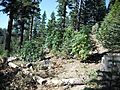
Typical Concow Pot Garden (2013)

See also
 In Spanish: Concow para niños
