
Conejos, Colorado facts for kids
Quick facts for kids
Conejos, Colorado
|
|
|---|---|

Conejos County Courthouse in Conejos.
|
|

Location of the Conejos CDP in Conejos County, Colorado.
|
|

Conejos, Colorado
Location in the United States
|
|
| Country | |
| State | |
| County | Conejos County |
| Founded | 1858 |
| Government | |
| • Type | unincorporated town |
| Area | |
| • Total | 0.484 sq mi (1.254 km2) |
| • Land | 0.484 sq mi (1.254 km2) |
| • Water | 0 sq mi (0.000 km2) |
| Elevation | 7,897 ft (2,407 m) |
| Population
(2010)
|
|
| • Total | 58 |
| • Density | 120/sq mi (46/km2) |
| Time zone | UTC-7 (MST) |
| • Summer (DST) | UTC-6 (MDT) |
| ZIP Code |
81129
|
| Area code(s) | 719 |
| GNIS feature | Conejos CDP |
Conejos is an unincorporated town, a post office, a census-designated place (CDP), and the county seat of Conejos County, Colorado, United States. The Conejos post office has the ZIP Code 81129. At the United States Census 2010, the population of the Conejos CDP was 58, while the population of the 81129 ZIP Code Tabulation Area was 156 including adjacent areas. Conejos is the only unincorporated county seat in the State of Colorado.
Contents
Geography
Conejos is located in southeastern Conejos County at 37°05′19″N 106°01′12″W / 37.08861°N 106.02000°W (37.088597,-106.019955). It is bordered to the south by the town of Antonito. U.S. Route 285 forms the eastern edge of the community and leads north 28 miles (45 km) to Alamosa, Colorado, and south 31 miles (50 km) to Tres Piedras, New Mexico.
According to the U.S. Census Bureau, Conejos has a total area of 0.48 square miles (1.25 km2), all of it land.
Demographics
The United States Census Bureau initially defined the Conejos CDP for the United States Census 2010.
| Conejos CDP, Colorado | ||
|---|---|---|
| Year | Pop. | ±% |
| 2010 | 58 | — |
| 2020 | — | |
| Source: United States Census Bureau | ||
Images for kids
-
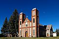
Our Lady of Guadalupe Catholic Church in Conejos.

See also
 In Spanish: Conejos (Colorado) para niños
