
Connecticut Turnpike facts for kids
Quick facts for kids
|
|
|---|---|
| Connecticut Turnpike | |

Map of southern Connecticut with Connecticut Turnpike highlighted in red
|
|
| Route information | |
| Maintained by ConnDOT | |
| Length | 128.47 mi (206.75 km) |
| Existed | 1958–present |
| Component highways |
|
| Major junctions | |
| West end | |
|
|
| East end | |
| Location | |
| Counties: | Fairfield, New Haven, Middlesex, New London, Windham |
| Highway system | |
| Routes in Connecticut Special Service Roads • State Roads |
|

The Connecticut Turnpike (also known as Governor John Davis Lodge Turnpike) is a freeway in Connecticut. It runs from Byram to South Killingly. It is approximately 135 miles long (94 miles on Interstate 95, 37 miles on Interstate 395, and 4 miles on State Route 695).
The Connecticut Turnpike opened in the early 1950s as the state's main highway. Once the road was considered paid for, and also due to several accidents near the toll booths, tolls were removed from the road in 1985. The turnpike was renamed for former Governor John Davis Lodge soon afterward. Very few signs nowadays identify the route as one unified road, and the section that runs as Route 695 carries no current identification at all (not even CT 695 markers) except to say that eastbound it goes "To US 6" and westbound it goes "To I-395".
Images for kids
-
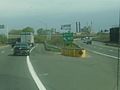
Northbound exit 48 offramp from the I-95 section, before the reconstruction of the I-95/I-91 interchange
-
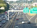
Northbound I-95 in Stamford
-
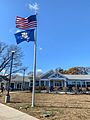
Fairfield Service Plaza southbound


