
Contour line facts for kids

A contour line (also level set, isopleth, isoline, isogram or isarithm) for a function of two variables is a curve connecting points where the function has a same particular value. A contour map is a map illustrated with contour lines. The prefix iso-, the Greek prefix for "equal", refers to maps with lines that join points of equal value.
The gradient of the function is always perpendicular to the contour lines. When the lines are close together the length of the gradient is large: the variation is steep. If adjacent contour lines are of the same line width, the direction of the gradient cannot be determined from the contour lines alone. However if contour lines rotate through three or more widths, or if the lines are numerically labelled, then the direction of the gradient can also be determined from the contour lines.
Contour lines are curved or straight lines on a map describing the intersection of a real or hypothetical surface with one or more horizontal planes. The configuration of these contours allows map readers to infer relative gradient of a parameter and estimate that parameter at specific places. Contour lines may be either traced on a visible three-dimensional model of the surface, as when a photogrammetrist viewing a stereo-model plots elevation contours, or interpolated form estimated surface elevations, as when a computer program threads contours through a network of observation points ot area centroids. In the latter case, the method of interpolation affects the reliability of individual isolines and their portrayal of slopes, pits and peaks (see Davis, 1986, Statistics and data analysis in geology).
Types of contour lines


Various types of contour lines are given different names according to the nature of the variable being mapped:
- acid precipitation: isoplat.
- air pollutant: isopleth.
- atmospheric density: isostere.
- aurora equal occurrence: isochasm
- biological events occurring with coincidence such as plants flowering: isophene
- cloud cover: isoneph
- illuminance: isophote.
- depth of water with equal temperature: isobathytherm.
- dew point: isodrosotherm.
- economic production: isoquant.
- elevation: contour lines on a topographic map or isohypse.
- underwater depth: isobath.
- humidity: isohume.
- ice formation location each winter: isopectic.
- liquid precipitation amount: isohyet.
- magnetic declination: isogon.
- magnetic declination annual change: isopor.
- ocean salinity: isohaline
- presence of linguistic feature: isogloss.
- pressure: isobar.
- radiation intensity: isodose
- solar radiation: isohel.
- sound level: contour line.
- summer temperature mean: isothere.
- temperature: isotherm.
- temperature mean: isogeotherm.
- transport costs from the source of a raw material: isotim.
- volume: isochor.
- wind direction: isogon.
- wind speed: isotach.
- winter temperature mean: isocheim
- drive time: isochrone.
- frequency of hail storms: isochalaz.
- time of thawing: isotac.
- cost of travel time: isodopane.
"Iso" can be replaced with "isallo" to specify a contour line connecting points where a variable has changed at the same rate during a given time period.
Technical construction factors
To maximize readability of contour maps, there are several design choices available to the map creator, principally line weight, line color, line type and method of numerical marking.
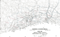
Line weight is simply the darkness or thickness of the line used. This choice is made based upon the least intrusive form of contours that enable the reader to decipher the background information in the map itself. If there is little or no content on the base map, the contour lines may be drawn with relatively heavy thickness. Also, for many forms of contours such as topographic maps, it is common to vary the line weight and/or color, so that a different line characteristic occurs for certain numerical values. For example, in the topgraphic map above, the even hundred foot elevations are shown in a different weight from the twenty foot intervals.
Line color is the choice of any number of pigments that suit the display. Sometimes a sheen or gloss is used as well as color to set the contour lines apart from the base map.
Line type refers to whether the basic contour line is solid, dashed, dotted or broken in some other pattern to create the desired effect. Dotted or dashed lines are often used when the underlying base map conveys very important (or difficult to read) information.
Numerical marking is the manner of denoting the arithmetical the values of contour lines. This can be done by placing numbers along some of the contour lines, typically using interpolation for intervening lines. The direction of these text labels is often used to indicate the direction of the slope. Alternatively a map key can be produced associating the contours with their values.
Images for kids
-
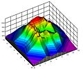
A three-dimensional surface, whose contour graph is below.
-
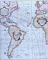
Edmond Halley's New and Correct Chart Shewing the Variations of the Compass (1701)
-
Isohyetal map of precipitation
-
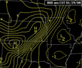
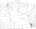
Video loop of isallobars showing the motion of a cold front
-
Isogonic lines for the year 2000. The agonic lines are thicker and labeled with "0".
-
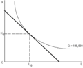
A single production isoquant (convex) and a single isocost curve (linear). Labor usage is plotted horizontally and physical capital usage is plotted vertically.
-
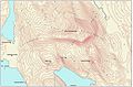
Contour map labeled aesthetically in an "elevation up" manner.


See also
 In Spanish: Isolínea para niños
