
Coolac, New South Wales facts for kids
Quick facts for kids CoolacNew South Wales |
|||||||||
|---|---|---|---|---|---|---|---|---|---|

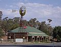
Coolac Hotel
|
|||||||||

Coolac
Location in New South Wales
|
|||||||||
| Population | 216 (2016 census) | ||||||||
| Established | 1824 | ||||||||
| Postcode(s) | 2727 | ||||||||
| Elevation | 308 m (1,010 ft) | ||||||||
| Location |
|
||||||||
| LGA(s) | Gundagai Council | ||||||||
| County | Harden | ||||||||
| State electorate(s) | Cootamundra | ||||||||
| Federal Division(s) | Riverina | ||||||||
|
|||||||||
Coolac is a village in the Riverina region of New South Wales, Australia in Gundagai Council. At the 2016 census, Coolac had a population of 216.
Coolac Geological Site
The Coolac Geological Site 48 kilometres (30 mi) north-east of Coolac, is the best known example in Australia of a substantial ophiolite assemblage. The distinctive rock assemblage over a 130-hectare (320-acre) site provides insights into events in the continental evolution of eastern Australia. The rocks here were part of the oceanic crust and mantle, normally not exposed on the Earth's surface. The rock from the mantle is called Coolac Serpentinite.
Images for kids
-
Windmill Cottage, Coolac


All content from Kiddle encyclopedia articles (including the article images and facts) can be freely used under Attribution-ShareAlike license, unless stated otherwise. Cite this article:
Coolac, New South Wales Facts for Kids. Kiddle Encyclopedia.