
Coorparoo, Queensland facts for kids
Quick facts for kids CoorparooBrisbane, Queensland |
|||||||||||||||
|---|---|---|---|---|---|---|---|---|---|---|---|---|---|---|---|

Coorparoo State School
|
|||||||||||||||

Coorparoo
Location in Queensland
|
|||||||||||||||
| Population | 16,282 (2016 census) | ||||||||||||||
| • Density | 3,015/km2 (7,810/sq mi) | ||||||||||||||
| Postcode(s) | 4151 | ||||||||||||||
| Area | 5.4 km2 (2.1 sq mi) | ||||||||||||||
| Time zone | AEST (UTC+10:00) | ||||||||||||||
| Location | 5.7 km (4 mi) SE of Brisbane GPO | ||||||||||||||
| LGA(s) | City of Brisbane (Coorparoo Ward) |
||||||||||||||
| State electorate(s) | Greenslopes | ||||||||||||||
| Federal Division(s) | Griffith | ||||||||||||||
|
|||||||||||||||
Coorparoo is a suburb in the City of Brisbane, Queensland, Australia. In the 2016 census, Coorparoo had a population of 16,282 people.
Contents
Toponymy
Coorparoo was chosen as the name of the suburb at a public meeting on 22 March 1875, before which it was known as Four Mile Camp. The name Coorparoo is likely derived from an Aboriginal name for Norman Creek, probably recorded by early surveyors as Koolpuroom. The word is thought to refer to either a place associated with mosquitoes, or a sound made by the 'gentle dove'. The latter explanation appears doubtful though, as 'gentle dove' may mean the spotted dove, which was introduced to the area in 1912, long after the name Coorparoo was adopted.
History
Aboriginal history
The Coorparoo Clan lived south of the Brisbane River and generally camped along creeks. Their name comes from Kulpurum, which was the word for Norman Creek or a tributary of it. They continued to occupy watercourse campsites after white settlement, but other clans from the region began to move into South Brisbane.
In 1846, there were reports of Aborigines raiding produce along Norman Creek. In 1853, there was a fight between Ningy Ningy, Bribie Island, Amity Point, and Logan peoples at Norman Creek. A visitor in 1855 reported many camps and fishing spots between Stones Corner and the mouth of Norman Creek. In 1959 an eighty-year-old woman told of frequent corroborees on the banks of the creek in Norman Park. Corroborees were also held at a little creek that crossed Norfolk Street.
Urban development

On 17 June 1856, ten farms were sold from the Parish of Bulimba near Stones Corner. Investors bought all but two of them. The next year James Warner surveyed land on the other side of the road for a second land auction.
Samuel Stevens donated two acres of his property near the junction of Cavendish and Old Cleveland Roads for use of a school. He declined the offer of naming the area "Steven's Town".
In 1876, the Coorparoo State School was opened and Frederick Robinson began offering public transport in a wagonette from Coorparoo Junction to Victoria Bridge. The 1880s land boom was a spur to profit from land. John Black was the first to subdivide land in the area in 1882 and later a variety of subdivisions were offered to the public. The construction of the bridge at Stanley Street (1886) and the development of the Stanley Bridge Estate made the area more attractive to purchasers. In 1887, the tramway was extended to Buranda, putting the western end of Coorparoo close to tram travel.
Coorparoo had been part of the Bulimba Divisional Board since 1879. However, in 1888, as a result of dissatisfaction with this situation, a petition was taken resulting in the creation of Shire of Coorparoo. A bridge was built at Burnetts Swamp (Stones Corner) and important road improvements took place. Development was taking off. In 1889 there were 2,500 people in the shire.
The floods of 1889 and 1893 hit the low-lying areas of Coorparoo. The flooding combined with the 1890s depression slowed development in the area. In 1900 there were actually fewer houses than there had been ten years earlier. The settlement was dense from Stones Corner to Kirkland Avenue (originally named Wecker Street but it was changed in 1914 in the wake of anti-German sentiment), but further out it was mainly bush with a few isolated farms and houses. The only major industry was the brickworks of Abraham James at St Leonards Street, which employed eighty men in the 1880s.
After World War I, land prices increased as property sales boomed. Coorparoo did not really begin to expand again until the tram service was extended to Stones Corner in 1902 and Coorparoo Junction in 1915. The number of houses increased from 613 in 1911 to 1,467 ten years later.
Demographics
The 2011 Census recorded 14,944 residents in Coorparoo, of whom 50.8% were female and 49.2% were male. The median age of the population was 33; 4 years younger than the Australian average.
71.4% of people living in Coorparoo were born in Australia, with the next most common countries of birth being New Zealand (3.7%), England (3%), India (2.9%), the Philippines (0.7%), and China (0.6%). 80.2% of people spoke English as their first language, while the other most common responses were Spanish (1%), Greek (1%), Hindi (0.8%), Mandarin (0.8%), and Italian (0.7%).
Future Growth
In 2015, demolition of the old Myer Department store on the corner of Old Cleveland Road and Cavendish Road commenced. In its place will be 3 residential towers with commercial development on the lower floors. The development, known as Coorparoo Square is due to open in 2017 and will feature a 10 screen Dendy cinema, Aldi Supermarket and speciality retailers and coffee shops. Under the development, will be a void for the future Eastern Busway station.
Landmarks
Coorparoo has a range of distinctive homes, buildings, and sites of interest, including:
- Spanish Mission Revival homes along Cavendish Road. This was a popular inter-war house style introduced from California.
- Ridgelands (1880s), built for the Blundell family
- Cardington (1880s) located at the corner of Norfolk Street and Cavendish Road. This residence was built by Thomas Howling who had purchased the allotments from early settler George Harden.
- Barston Place (1880) on Norfolk Street, built for Scottish born James Burstall and named after his birthplace.
- Coorparoo Shire Hall (1892) located at the corner of Cavendish Road and Halstead Street. The building is now owned by the Coorparoo RSL Club and is now known as the Coorparoo School of Arts.
- Restored Tram Post located at the corner of Old Cleveland and Cavendish Roads.
- Hatherton (1886). This elite residence was built for Reubin Nicklin who previously residence was called Langlands. Reubin and his wife Jane were drowned in the RMS Quetta disaster in 1890. The house has subsequently been extensively renovated and changed and is known as the "Queen Alexandra Home" having been used as a Methodist Home for children, teaching classrooms for the local TAFE College and more recently as a community centre.
- Chatsworth (1888), built for William Evans who worked at Stewarts of Stones Corner. Chatsworth Road is named after this residence.
- Langlands (1883), built for Reubin Nicklin. This building is located in the grounds of the present Villanova College and is the oldest surviving masonry residence in Coorparoo.
- Cavendish Road
- Kirkland Avenue. An affluent tree lined street offering sweeping panoramic views of the Brisbane CBD.
Heritage listings
Coorparoo has a number of heritage-listed sites, including:
- Coorparoo Substation No. 210 (12 Main Avenue)
- Coorparoo School of Arts and RSL Memorial Hall (208 Cavendish Road)
- former Coorparoo Fire Station (219 Cavendish Road)
- Queen Alexandra Home (347 Old Cleveland Road)
Education
Coorparoo State School is a government primary (Prep-6) school for boys and girls at 327 Old Cleveland Road (27°29′38″S 153°03′38″E / 27.4940°S 153.0605°E). In 2018, the school had an enrolment of 824 students with 57 teachers (49 full-time equivalent) and 22 non-teaching staff (15 full-time equivalent). It includes a special education program.
St James Primary School is a Catholic primary (Prep-6) school for boys and girls at 92 Kirkland Avenue (27°29′58″S 153°03′09″E / 27.4995°S 153.0524°E). In 2018, the school had an enrolment of 140 students with 15 teachers (10 full-time equivalent) and 7 non-teaching staff (5 full-time equivalent).
Our Lady of Mount Carmel School is a Catholic primary (Prep-6) school for boys and girls at Norfolk Street (27°30′10″S 153°03′45″E / 27.5027°S 153.0626°E). In 2018, the school had an enrolment of 576 students with 40 teachers (32 full-time equivalent) and 22 non-teaching staff (13 full-time equivalent).
Brisbane School of Distance Education is a government primary and secondary (Early Childhood-12) school for boys and girls on the corner of Stanley Street andCavendish Road (27°29′11″S 153°03′14″E / 27.4865°S 153.0538°E). In 2018, the school had an enrolment of 3,467 students with 260 teachers (237 full-time equivalent) and 83 non-teaching staff (68 full-time equivalent). It includes a special education program.
Villanova College is a Catholic primary and secondary (5-12) school for boys at 24 Sixth Avenue (27°29′46″S 153°03′04″E / 27.4960°S 153.0510°E). In 2018, the school had an enrolment of 1230 students with 98 teachers (96 full-time equivalent) and 63 non-teaching staff (50 full-time equivalent).
Coorparoo Secondary College is a government secondary (7-12) school for boys and girls on the corner Stanley Street East and Cavendish Road (27°29′11″S 153°03′13″E / 27.4863°S 153.0537°E). In 2018, the school had an enrolment of 409 students with 49 teachers (44 full-time equivalent) and 23 non-teaching staff (18 full-time equivalent). It includes a special education program. It includes the Coorparoo Centre for Continuing Secondary Education.
Loreto College Coorparoo is a Catholic secondary (7-12) school for girls at 415 Cavendish Road (27°30′36″S 153°03′50″E / 27.5099°S 153.0639°E). In 2018, the school had an enrolment of 833 students with 72 teachers (68 full-time equivalent) and 43 non-teaching staff (36 full-time equivalent).
Queensland Pathways State College is a government secondary (10-12) school for boys and girls at 327 Old Cleveland Road (27°29′38″S 153°03′40″E / 27.4940°S 153.0612°E). In 2018, the school had an enrolment of 198 students with 26 teachers (24 full-time equivalent) and 18 non-teaching staff (17 full-time equivalent).
Images for kids
-
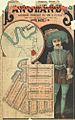
Real estate map of Langlands Estate East, Coorparoo, 1886
-
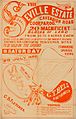
Estate map of the Seville Estate, Cavendish Road, Coorparoo, Brisbane, Queensland, 1888.
-
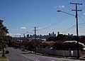
Brisbane Central Business District viewed from Upper Cornwall Street, Coorparoo.
.jpg)
.jpg)

