
Copper Harbor, Michigan facts for kids
Quick facts for kids
Copper Harbor, Michigan
|
|
|---|---|

Aerial view of the Copper Harbor community
|
|

Location within Keweenaw County
|
|

Copper Harbor, Michigan
Location in Michigan

Copper Harbor, Michigan
Location in the United States
|
|
| Country | United States |
| State | Michigan |
| County | Keweenaw |
| Township | Grant |
| Established | 1844 |
| Area | |
| • Total | 2.43 sq mi (6.3 km2) |
| • Land | 1.51 sq mi (3.9 km2) |
| • Water | 0.92 sq mi (2.4 km2) |
| Elevation | 605 ft (184 m) |
| Population
(2010)
|
|
| • Total | 108 |
| • Density | 71.5/sq mi (27.6/km2) |
| Time zone | UTC−5 (Eastern (EST)) |
| • Summer (DST) | UTC−4 (EDT) |
| ZIP code(s) |
49918
49950 (Mohawk) |
| Area code(s) | 906 |
| FIPS code | 26-18100 |
| GNIS feature ID | 623809 |
Copper Harbor is an unincorporated community and census-designated place (CDP) located in Keweenaw County in the U.S. state of Michigan. It is located within Grant Township. The population of the CDP was 136 as of the 2020 census.
The community is located at the northern tip of the Keweenaw Peninsula. Copper Harbor is also the northernmost permanently populated community and northernmost point of mainland in the state of Michigan. Due to its natural environment and surroundings, Copper Harbor is marketed as an all-season tourist destination and also contains Fort Wilkins Historic State Park.
Contents
History
The town's name alludes to the former use of its harbor as a port for shipping copper mined from local deposits during the mid-19th century.
The Pittsburgh and Boston Mining Company, formed by John Hays of Cleveland, Ohio, began operating in Copper Harbor in 1844. It was a small development at first, but its mine was modern for its time, and the company struck it rich in 1845. A few years later, the Central and other mines opened and became successful. By 1870, the copper resources had been largely worked out.
Mining activity no longer exists, and the town's harbor is mostly used for recreational purposes such as snowmobiling and for a ferry that connects Isle Royale National Park to northern Michigan.
Parks and recreation
The Copper Harbor Lighthouse is situated at the opening of the harbor. Nearby is Fort Wilkins Historic State Park, a restored 1844 frontier army base originally built to protect the port in the early years of the copper mining boom.
Transportation
Highways
 US 41 travels through Copper Harbor and has its northernmost terminus just east of the community.
 M-26 has its northernmost terminus at U.S. Route 41 within the western portion of the community.
Ferry services
Copper Harbor contains a ferry port that provides transportation to Isle Royale National Park. The Isle Royale Line, Inc. (formerly named Isle Royale Ferry Service) operates the Isle Royale Queen IV out of Copper Harbor during the warmer months from May to September. The ferry takes 3.5 hours to travel 60 miles (97 km) across Lake Superior to Rock Harbor.
Geography
Copper Harbor is at 47°28′08″N 87°53′18″W / 47.4687939°N 87.8884416°W; this puts it further north than anywhere in the state of Maine. The ZIP code is 49918 and the FIPS place code is 18100.
Climate
Copper Harbor has a humid continental climate. Summers are warm but rarely hot due to the moderating influence of Lake Superior, whilst winters are cold and snowy, albeit milder than areas on similar parallels to the west, due to the low-scale maritime moderation. Although winter temperatures are similar to those in nearest large metropolitan city Minneapolis a couple of degrees latitude south-west, the main difference being that March is also a winter month in Copper Harbor, since the marine effects delay spring.
| Climate data for Copper Harbor, Michigan (1981–2010 normals, extremes 1972–present) | |||||||||||||
|---|---|---|---|---|---|---|---|---|---|---|---|---|---|
| Month | Jan | Feb | Mar | Apr | May | Jun | Jul | Aug | Sep | Oct | Nov | Dec | Year |
| Record high °F (°C) | 46 (8) |
55 (13) |
70 (21) |
83 (28) |
89 (32) |
94 (34) |
99 (37) |
94 (34) |
95 (35) |
81 (27) |
67 (19) |
56 (13) |
99 (37) |
| Average high °F (°C) | 23.1 (−4.9) |
25.9 (−3.4) |
34.7 (1.5) |
46.0 (7.8) |
58.9 (14.9) |
67.5 (19.7) |
74.0 (23.3) |
74.0 (23.3) |
66.0 (18.9) |
52.3 (11.3) |
39.1 (3.9) |
27.8 (−2.3) |
49.1 (9.5) |
| Average low °F (°C) | 9.8 (−12.3) |
10.1 (−12.2) |
18.2 (−7.7) |
29.8 (−1.2) |
39.4 (4.1) |
47.0 (8.3) |
54.9 (12.7) |
56.9 (13.8) |
50.5 (10.3) |
39.1 (3.9) |
28.0 (−2.2) |
17.1 (−8.3) |
33.4 (0.8) |
| Record low °F (°C) | −18 (−28) |
−22 (−30) |
−23 (−31) |
−2 (−19) |
22 (−6) |
32 (0) |
42 (6) |
44 (7) |
30 (−1) |
21 (−6) |
6 (−14) |
−8 (−22) |
−23 (−31) |
| Average precipitation inches (mm) | 2.65 (67) |
1.44 (37) |
1.71 (43) |
2.18 (55) |
3.11 (79) |
2.69 (68) |
2.18 (55) |
2.63 (67) |
2.96 (75) |
3.28 (83) |
2.83 (72) |
2.33 (59) |
29.99 (760) |
| Average snowfall inches (cm) | 42.9 (109) |
22.5 (57) |
13.1 (33) |
6.6 (17) |
0.5 (1.3) |
0 (0) |
0 (0) |
0 (0) |
0 (0) |
0.3 (0.76) |
9.9 (25) |
28.9 (73) |
124.7 (317) |
| Average precipitation days (≥ 0.01 in) | 15.9 | 11.5 | 8.0 | 7.8 | 10.0 | 8.7 | 8.7 | 7.4 | 10.3 | 11.9 | 10.7 | 12.9 | 123.8 |
| Average snowy days (≥ 0.1 in) | 18.1 | 12.3 | 6.8 | 3.1 | 0.2 | 0 | 0 | 0 | 0 | 0.5 | 5.9 | 12.5 | 59.4 |
| Source: NOAA | |||||||||||||
Images for kids
-
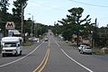
Looking west in downtown Copper Harbor
-
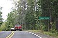
Sign on US 41
-
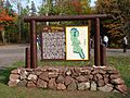
Welcome sign
-
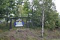
A marker at the northern terminus of US 41 just east of Copper Harbor


Images for kids
-
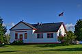
Copper Harbor Schoolhouse in 2020

See also
 In Spanish: Copper Harbor (Míchigan) para niños
