
Cordillera Administrative Region facts for kids
Quick facts for kids
Cordillera Administrative Region
CAR
|
|
|---|---|
     From top, left to right: Batad Rice Terraces; Tayum Church; Lubuagan, Kalinga; Colors of StoBoSa, Hanging coffins of Sagada
|
|

Location in the Philippines
|
|
| Country | |
| Island group | Luzon |
| Regional center | Baguio |
| Area | |
| • Total | 19,422.03 km2 (7,498.89 sq mi) |
| Population
(2015)
|
|
| • Total | 1,722,006 |
| • Density | 88.66251/km2 (229.63486/sq mi) |
| Time zone | UTC+8 (PST) |
| ISO 3166 code | PH-15 |
| Provinces | |
| Cities |
2
Baguio
Tabuk |
| Municipalities | 75 |
| Barangays | 1,176 |
Cordillera Administrative Region is an administrative region in the Philippines. It is on the island of Luzon. The regional center is Baguio.
It was created on July 15, 1987. There are 6 provinces: Abra, Apayao, Benguet, Ifugao, Kalinga and Mountain Province.
Mount Pulag, the highest mountain in Luzon, is in the region. Rivers include the Chico River, Abulog, and Siffu River. Tourist sites include Banaue Rice Terraces, Cassamata Hill National Park, and Balbalasang-Balbalan National Park.
Images for kids
-
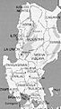
An old U.S. Army map showing Mountain province covering the present areas of Benguet, Ifugao, Kalinga and Apayao
-
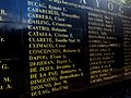
Detail of the Wall of Remembrance at the Bantayog ng mga Bayani in Quezon City, showing names from the first batch of Bantayog Honorees, including that of Macli-ing Dulag.
-
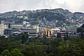
A view of Baguio City as seen in November 2012
-
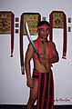
A man from Tinglayan vested in traditional garb holding a handcrafted weapon first produced during the Second World War; traditional Kalinga cloth is draped over Orthodox icons in the manner of Russian nabozhnyks.
-
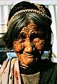
A Bontoc woman with a snake skeleton in her hair. Skeletons serve as a charm against lightning.
-
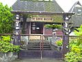
The Bontoc Museum, run by the Sisters of the Immaculate Heart of Mary, hosts many of the materials used by the different tribes of the Mountain Province.
-
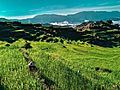
Maligcong rice terraces in Bontoc, Mountain Province


See also
 In Spanish: La Cordillera para niños
