Cordillera Domeyko facts for kids
Quick facts for kids Cordillera Domeyko |
|
|---|---|

Cerro Quimal in the distance
|
|
| Highest point | |
| Peak | Cerro Quimal |
| Elevation | 4,278 m (14,035 ft) |
| Dimensions | |
| Length | 600 km (370 mi) north-south |
| Geography | |
| Country | Chile |
| Range coordinates | 24°30′S 69°00′W / 24.500°S 69.000°W |
| Parent range | Central Andes |

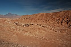
Cordillera de la Sal, part of Cordillera Domeyko. In the distance can be seen Licancabur and Juriques.
The Cordillera Domeyko is a mountain range of the Andes located in northern Chile, west of Salar de Atacama. It runs north-south for approximately 600 km, parallel to the main chain. The mountain range marks the eastern border of the flat parts of Atacama Desert. The western border of Cordillera Domeyko is characterized by a inland cliffs and a sharp topographic transition known as El Bordo Escarpment. El Bordo Escarpment contain the main rock outcrops of the Purilactis Group, which make up much of the mountain range.
Cordillera Domeyko was named after Ignacy Domeyko and is the world's lowest humidity mountain range.
See also
 In Spanish: Cordillera Domeyko para niños

All content from Kiddle encyclopedia articles (including the article images and facts) can be freely used under Attribution-ShareAlike license, unless stated otherwise. Cite this article:
Cordillera Domeyko Facts for Kids. Kiddle Encyclopedia.
