
County Galway facts for kids
Quick facts for kids
County Galway
Contae na Gaillimhe
|
||
|---|---|---|
|
||
| Nickname(s):
The Hooker County
|
||
| Motto(s): | ||

Location in Ireland
|
||
| Country | Ireland | |
| Province | Connacht | |
| Established | c. 1569 | |
| County town | Galway | |
| Government | ||
| • Type | County Council and City Council | |
| Area | ||
| • Total | 6,151 km2 (2,375 sq mi) | |
| Area rank | 2nd | |
| Highest elevation
(Benbaun)
|
729 m (2,392 ft) | |
| Population
(2016)
|
||
| • Total | 258,058 | |
| • Rank | 5th | |
| • Density | 41.954/km2 (108.660/sq mi) | |
| Time zone | UTC±0 (WET) | |
| • Summer (DST) | UTC+1 (IST) | |
| Eircode routing keys |
F31, H53, H54, H62, H65, H71, H91 (primarily)
|
|
| Telephone area codes | 090, 091, 093, 099 (primarily) | |
| Vehicle index mark code |
G | |
| Website | and | |

County Galway ( GAWL-way; Irish: Contae na Gaillimhe) is a county in Ireland. It is in the West of Ireland, taking up the south of the province of Connacht.
There are several Irish-speaking areas in the west of the county. The traditional county includes, and is named for, the city of Galway, but the city and county are separate local government areas, administered by the local authorities of Galway City Council in the urban area and Galway County Council in the rest of the county.
The population of the county was 258,058 at the 2016 census.
Contents
History

The first inhabitants in the Galway area arrived over 7000 years ago. Shell middens indicate the existence of people as early as 5000 BC.
The county originally comprised several kingdoms and territories which predate the formation of the county. These kingdoms included Aidhne, Uí Maine, Maigh Seóla, Conmhaícne Mara, Soghain and Máenmaige. County Galway became an official entity around 1569 AD. In modern times, a number of inhabited islands are also administered by the county; these include Oileáin Árann (Aran Islands) and Inis Bó Fine (Inishbofin).
With the arrival of Christianity many monasteries were built in the county. Monasteries kept written records of events in the area and of its people. These were followed by a number of law-tracts, genealogies, annals and miscellaneous accounts. Extant manuscripts containing references to Galway include:
|
|
Irish language
Nearly 20% of the population of County Galway live in the Gaeltacht (Gaelic-speaking districts). County Galway is home to the largest Gaeltacht Irish-speaking region in Ireland. There are over 48,907 people living within this region which extends from Galway city westwards through Connemara. The region consists of the following Irish speaking areas; Galway City Gaeltacht, Gaeltacht Cois Fharraige, Conamara Theas, Aran Islands and Duiche Sheoigheach.
All schools within the Gaeltacht use the Irish language for classroom instruction. There is also a third-level constituent college of NUIG called Acadamh na hOllscolaíochta Gaeilge in Carraroe and Carna. Spiddal is the largest town in the region. Galway city is also home to Ireland's only Irish-language theatre Taibhdhearc na Gaillimhe. There is a strong Irish-language media presence in this area too, which boasts the radio station Raidió na Gaeltachta and Foinse newspaper in Carraroe and national TV station TG4 in Baile na hAbhann. The Aran Islands are also part of the Galway Gaeltacht.

There are about 30,000 - 40,000 Irish speakers in County Galway. According to Census 2011, the Galway city and county Gaeltacht has a population of 48,907, of which 30,978 say they can speak Irish, 23,788 can be classed as native Irish speakers while 7,190 speak Irish daily only within the classroom. There are 3,006 attending the ten Gaelscoil (Irish language primary schools) and three Gaelcholáiste (Irish language secondary schools) outside of the Galway Gaeltacht. According to the Irish Census 2006 there are 10,788 in the county who identify themselves as being daily Irish speakers outside of the education system.
Geography

County Galway is home to Na Beanna Beola (Twelve Bens) mountain range, Na Sléibhte Mhám Toirc (the Maum Turk mountains), and the low mountains of Sliabh Echtghe (Slieve Aughty). The highest point in the county is one of the Twelve Bens, Benbaun, at 729m.
Lakes
County Galway is partly home to a number of Ireland's largest lakes including Lough Corrib (the largest lake in the Republic of Ireland), Lough Derg and Lough Mask. The county is also home to a large number of smaller lakes, many of which are in the Connemara region. These include Lough Anaserd, Ardderry Lough, Aughrusbeg Lough, Ballycuirke Lough, Ballynahinch Lake, Lough Bofin, Lough Cutra, Derryclare Lough, Lough Fee, Glendollagh Lough, Lough Glenicmurrin, Lough Inagh, Kylemore Lough, Lettercraffroe Lough, Maumeen Lough, Lough Nafooey, Lough Rea, Ross Lake and Lough Shindilla.
Climate
The location of County Galway, situated on the west coast of Ireland, allows it to be directly influenced by the Gulf Stream. Temperature extremes are rare and short lived, though inland areas, particularly east of the Corrib, can boast some of the highest recorded temperatures of the summer in the island of Ireland (sometimes exceeding 30 °C); though these temperatures only occur when land warmed east winds sweep the area; the opposite effect can occur in the winter. Overall, however, Galway is influenced mainly by Atlantic airstreams which bring ample rainfall in between the fleeting sunshine. Rainfall occurs in every month of the year, though the late autumn and winter months can be particularly wet as Atlantic cyclonic activity increases and passes over and around the area, and which is why Galway tends to bear the brunt of severe windstorms that can occur between August and March. The county on average receives about 1300mm of rainfall annually, though some areas along the west coast of the county can receive up to 1900mm and beyond. Extreme weather such as blizzards, thunderstorms, flash flooding and hail, though rare, can and do occur, particularly when air masses of continental origin are undercut by more humid and unstable Atlantic flows.
Flora and fauna
One of the least densely populated counties, County Galway harbors a variety of wildlife. The region's biodiversity is best represented by Connemara National Park, situated in the west of the county.
Largest settlements in County Galway (2011 Census)
Towns and villages
| Historical population | ||
|---|---|---|
| Year | Pop. | ±% |
| 1600 | 19,706 | — |
| 1610 | 14,233 | −27.8% |
| 1653 | 18,209 | +27.9% |
| 1659 | 33,390 | +83.4% |
| 1668 | 45,678 | +36.8% |
| 1672 | 55,700 | +21.9% |
| 1680 | 58,950 | +5.8% |
| 1690 | 63,711 | +8.1% |
| 1700 | 65,112 | +2.2% |
| 1710 | 67,888 | +4.3% |
| 1720 | 70,345 | +3.6% |
| 1725 | 71,798 | +2.1% |
| 1735 | 73,470 | +2.3% |
| 1745 | 71,997 | −2.0% |
| 1755 | 68,955 | −4.2% |
| 1765 | 79,883 | +15.8% |
| 1771 | 81,225 | +1.7% |
| 1775 | 87,226 | +7.4% |
| 1781 | 94,666 | +8.5% |
| 1788 | 101,557 | +7.3% |
| 1790 | 116,774 | +15.0% |
| 1801 | 123,445 | +5.7% |
| 1811 | 145,333 | +17.7% |
| 1813 | 142,808 | −1.7% |
| 1816 | 155,297 | +8.7% |
| 1821 | 169,503 | +9.1% |
| 1831 | 204,691 | +20.8% |
| 1841 | 440,198 | +115.1% |
| 1851 | 321,684 | −26.9% |
| 1861 | 271,478 | −15.6% |
| 1871 | 248,458 | −8.5% |
| 1881 | 242,005 | −2.6% |
| 1891 | 214,712 | −11.3% |
| 1901 | 192,549 | −10.3% |
| 1911 | 182,224 | −5.4% |
| 1926 | 169,366 | −7.1% |
| 1936 | 168,198 | −0.7% |
| 1946 | 165,201 | −1.8% |
| 1951 | 160,204 | −3.0% |
| 1956 | 155,553 | −2.9% |
| 1961 | 149,887 | −3.6% |
| 1966 | 148,340 | −1.0% |
| 1971 | 149,223 | +0.6% |
| 1979 | 167,838 | +12.5% |
| 1981 | 172,018 | +2.5% |
| 1986 | 178,552 | +3.8% |
| 1991 | 180,364 | +1.0% |
| 1996 | 188,854 | +4.7% |
| 2002 | 209,077 | +10.7% |
| 2006 | 231,670 | +10.8% |
| 2011 | 250,541 | +8.1% |
| 2016 | 258,552 | +3.2% |
- Ahascragh
- Annaghdown
- Ardrahan
- Athenry
- Aughrim
- Ballinasloe
- Ballinderreen
- Ballyconneely
- Ballygar
- Ballymacward
- Ballymoe
- Ballynahinch
- Barna
- Bealadangan
- Belclare
- Bullaun
- Camus
- Carna
- Carnmore
- Carraroe
- Casla
- Castleblakeney
- Castlegar
- Claregalway
- Clarinbridge
- Cleggan
- Clifden
- Clonbur
- Clonfert
- Corofin
- Corrandulla
- Corr na Móna
- Craughwell
- Dunmore
- Eyrecourt
- Furbo
- Glenamaddy
- Gort
- Headford
- Hollygrove
- Inverin
- Kilcolgan
- Kilconly
- Kilconnell
- Kilkerrin
- Kilkieran
- Killimor
- Kilronan
- Kiltullagh
- Kinvara
- Knocknacarra
- Laurencetown
- Leenaun
- Lettercallow
- Letterfrack
- Lettermore
- Loughrea
- Maam Cross
- Maum
- Menlough
- Milltown
- Monivea
- Mountbellew
- Moycullen
- Muckanaghederdauhaulia
- Maree
- Newbridge
- New Inn
- Oranmore
- Oughterard
- Peterswell
- Portumna
- Recess
- Rosmuck
- Rossaveal
- Roundstone
- Roscam
- Skehana
- Spiddal
- Tully
- Tully Cross
- Tuam
- Turloughmore
- Williamstown
- Woodford
Economy
According to numbers published by Galway Chamber of Commerce in early 2019, there were then 196 information and communications technology (ICT) organisations in Galway, including IBM, SAP, Oracle and Cisco. There is a number of medical device companies in the area, including Medtronic (with approximately 1,800 employees) and Boston Scientific (2,800 employees).
Sports
Gaelic games are the most popular sport in the county. Galway had traditional regions in which Gaelic football or hurling is played. For example, in south and eastern County Galway, in places such as Portumna, Gort, Clarinbridge and Athenry, hurling is the dominant sport with successful teams at county and national level. Most of the rest of the county is considered to be footballing territory, with most of the county players being from The Tuam area, Oughterard, Moycullen or parts of Galway city.
Galway United FC compete in the SSE Aitricity League of Ireland and plays home games in Eamonn Deacy Park.
Connacht Rugby competes in the United Rugby Championship is based in Galway city. The two main amateur rugby clubs in the county are Galway Corinthians RFC and Galwegians RFC which compete in the All-Ireland League.
Athletics is also a very popular sport in Galway, a few clubs being; Galway City Harriers, Craughwell Athletic Club, Athenry A.C, Tuam A.C, Loughrea A.C and many others.
Images for kids
-
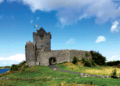
Dunguaire Castle, Kinvara, built c. 1520
-
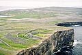
The prehistoric hill fort of Dún Aonghasa, Inishmore Island


See also
 In Spanish: Condado de Galway para niños
