
Perthshire facts for kids
| Perthshire | |
| Motto: Pro Lege et Libertate ('For Law and Liberty') |
|
 Perthshire within Scotland |
|
| Geography | |
| Status | Local government county (until 1975) Land registration county (1996 - ) |
| 1975 area | 2,528 sq mi (6,550 km2) (5th) |
| HQ | Perth (county town and administrative centre) |
| Chapman code | PER |
| History | |
| Succeeded by | Tayside Region |
Quick facts for kids Politics |
|
|---|---|
| Governance | County: Perthshire County Council (1890-1929) Perth and Kinross County Council (1929-1975) Modern: Perth and Kinross Council (1996 - ) Lieutenancy: Lord Lieutenant of Perth and Kinross |
 Coat of arms of the county council |
|
Perthshire ( Scottish Gaelic: Siorrachd Pheairt), officially the County of Perth, is a historic county and registration county in central Scotland. Geographically it extends from Strathmore in the east, to the Pass of Drumochter in the north, Rannoch Moor and Ben Lui in the west, and Aberfoyle in the south; it borders the counties of Inverness-shire and Aberdeenshire to the north, Angus to the east, Fife, Kinross-shire, Clackmannanshire, Stirlingshire and Dunbartonshire to the south and Argyllshire to the west. It was a local government county from 1890 to 1930.
Perthshire is known as the "big county", due to its roundness and status as the fourth largest historic county in Scotland. It has a wide variety of landscapes, from the rich agricultural straths in the east, to the high mountains of the southern Highlands.
Contents
Administrative History
Perthshire was an administrative county between 1890 and 1975, governed by a county council. This Local Government council was superseded in 1930, when a joint Local Government council was formed with the neighbouring small county of Kinross-shire, linking the two.
In 1975 this Local Government council was in turn superseded by the Local Government (Scotland) Act 1973 and split between the Local Government Central and Tayside Regions:
- West Perthshire (the area west and south of Killin including Callander, Crianlarich and Aberfoyle) was included in the Stirling District of Central Region.
- The parish of Muckhart and Glendevon was made part of Clackmannan District Council, also in Central Region Council.
- Longforgan was included in the City of Dundee District, in Tayside Region Council.
- The remainder of the council was combined with the council of Kinross and the Angus parish of Kettins to form Perth and Kinross District Council in Tayside.
The two-tier system introduced in 1975 was superseded by a system of unitary authorities in 1996.
The area of the former council is now divided between the Local Government council areas of Clackmannanshire, Perth and Kinross and Stirling.
The area included in Dundee in 1975 was transferred to Perth and Kinross.
Boundaries
Prior to the 1890s Perthshire's boundaries were irregular: the parishes of Culross and Tulliallan formed an exclave some miles away from the rest of the county, on the boundaries of Clackmannanshire and Fife; while the northern part of the parish of Logie formed an enclave of Stirlingshire within the county.
Following the recommendations of the council boundary commission appointed under the Local Government (Scotland) Act 1889, Culross and Tulliallan were transferred to Fife, and the entire parish of Logie was included in Stirlingshire.
Coat of arms
The coat of arms of the County of Perth appears to have been granted for use on the colours and standards of the volunteer and militia units of the county raised at the end of the eighteenth century. The Earl of Kinnoull, a native of Perthshire, and commanding officer of the Perthshire Gentlemen and Yeomanry Cavalry, was also Lord Lyon King of Arms at the time, and he presented the arms to the county in 1800. The grant document was discovered in the Lyon Office in 1890, and forwarded to the newly formed Perth County Council.
The shield is very similar to the Scottish royal arms, reflecting that Perthshire was the home county of the House of Dunkeld and contains the former royal capital, Scone. Further royal references are made on the canton, which shows Scone Palace surmounted by the Crown of Scotland. The crest is a Highland soldier, reflecting that the famous Black Watch were formed in the county. The supporters are an eagle and a warhorse, the former from the arms of the city of Perth.
Burghs
By the 1890s the county contained the following burghs, which were largely outside the county council's jurisdiction:
- Royal Burgh of Perth (which was styled a city)
- Burgh of Auchterarder (formed 1894: reinstated as a royal burgh in 1951)
- Burgh of Aberfeldy (police burgh from 1887)
- Burgh of Abernethy (burgh of barony from 1458/9, police burgh from 1877)
- Burgh of Alyth (police burgh 1834)
- Burgh of Blairgowrie (burgh of barony 1634, police burgh 1833)
- Burgh of Rattray (police burgh 1873)
- Burgh of Callander (police burgh 1866)
- Burgh of Coupar Angus (burgh of barony 1607, police burgh 1852)
- Burgh of Crieff (burgh of barony 1674, burgh of regality 1687, police burgh 1864)
- Burgh of Doune (burgh of barony 1611, police burgh 1890)
- Burgh of Dunblane (burgh of regality of the Bishop of Dunblane 1442, police burgh 1870)
The Local Government (Scotland) Act 1929 divided burghs into two classes from 1930: large burghs, which were to gain extra powers from the county council, and small burghs which lost many of their responsibilities.
Of the twelve burghs in Perthshire, only Perth was made a large burgh. There were ten small burghs: Blairgowrie and Rattray being united into a single burgh. In 1947 Pitlochry was created a small burgh.
Civil parishes

In 1894 parish councils were established for the civil parishes, replacing the previous parochial boards. The parish councils were in turn replaced by district councils in 1930.
Following the boundary changes caused by the Local Government (Scotland) Act 1889, the county contained the following civil parishes:
|
|
|
|
Towns and villages

Perthshire includes the City of Perth and the following other towns and villages (see also Civil Parish list):
- Bridge of Earn
- Bankfoot
- Crieff
- Dunkeld and Birnam
- Kenmore
- Kinloch Rannoch
- Luncarty
- Pitlochry
- Strathtay
Other towns and villages
Some others listed in alphabetical order in the Land Register Counties :
- Aberargy
- Aberdalgie
- Aberruthven
- Acharn
- Almondbank
- Altamount
- Amulree
- Ardagie
- Ardeonaig
- Ardler
- Argaty
- Ashfield
- Auchinlay
- Auchmore
- Auchtoo
- Auchtugh
- etc..
Districts
In 1930 the landward area of the Local Government councils (the part outside of burgh boundaries) was divided into five districts, replacing the parish councils established in 1894:
- Central District
- Eastern District
- Highland District
- Perth District
- Western District
Notable people
- Archbishop Patrick Adamson
- Duke of Atholl
- James Bannerman
- Anne Fraser Bon
- Edward Braddock
- Sir Archibald Campbell, 1st Baronet
- Baron Cameron of Balhousie
- James Croll
- Alan Cumming
- Sir Charles Douglas
- David Douglas
- Daniel Dow
- Duleep Singh
- Alexander Duff
- Thomas Duncan
- Adam Ferguson
- William Flockhart
- Duncan Forbes
- Niel Gow
- James Graham, 1st Marquess of Montrose
- Thomas Graham, 1st Baron Lynedoch
- Stephen Hendry
- Lady of Lawers
- Alexander Leslie, 1st Earl of Leven
- Alexander Mackenzie
- Dougie MacLean
- John James Rickard Macleod
- Ewan McGregor
- Sir Charles Menzies
- Lord George Murray
- Sir George Murray
- Baron Reid
- J.K. Rowling
- James Small
- Major-General John Small
- William Small
- Rory Stewart
- Magdalene Stirling
- Robert Stirling
- George Thompson, recipient of the Victoria Cross
- John Sen Inches Thomson
- Dr William Marshall
Rivers
Mountains
.jpg)
Glens and straths
- Glen Almond
- Glen Isla
- Glen Shee
- Glen Garry
- Glen Tilt
- Glen Bruar
- Glen Errochty
- Glen Rannoch
- Glen Lyon
- Glen Lochay
- Glen Dochart
- Strathmore
- Strath Ardle
- Strath Braan
- Strath Tay
- Strath Tummel
- Strath Fillan
- Strath Earn
Surnames
Most common surnames in Perthshire at the time of the United Kingdom Census of 1881, by order of incidence:
- Robertson
- Stewart
- Campbell
- McGregor
- McDonald
- Cameron
- McLaren
- Anderson
- Smith
- Ferguson
Transport

The Highland Main Line railway line connects Perth to Inverness, and in the far west the West Highland Line criss-crosses the Perthshire-Argyllshire boundary. Other lines in the south-east link Perth to the towns of Fife and Stirlingshire.
Images for kids
-
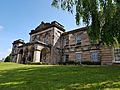
County Offices in York Place, the former headquarters of Perth County Council
-
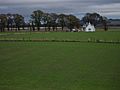
The uncharacteristically flat lands of the Carse of Gowrie
-
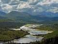
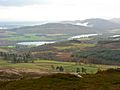
Typical Perthshire scenery around Loch Garry
-
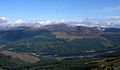
Ben Vorlich rising above Loch Lubnaig
-
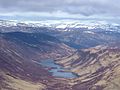
Loch Loch from summit of Ben Vuirich
-
The Loch of Butterstone as seen from Benachally Monument
-
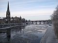
The River Tay at Perth
-
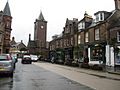
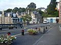
Crieff
-
Dunblane
-
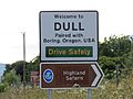
Dull welcome sign
-
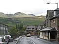
Killin
-
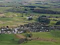
Pool of Muckhart


See also
 In Spanish: Perthshire para niños
