Cowley County, New South Wales facts for kids
Quick facts for kids CowleyNew South Wales |
|||||||||||||||
|---|---|---|---|---|---|---|---|---|---|---|---|---|---|---|---|

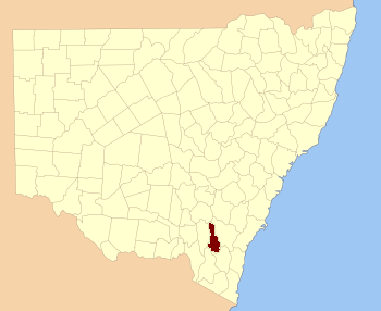
Location in New South Wales
|
|||||||||||||||
|
|||||||||||||||


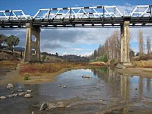
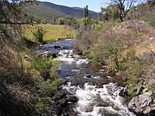
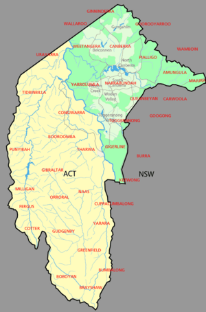
Cowley County is one of the 141 Cadastral divisions of New South Wales. It contains the locality of Cavan. It was originally bordered on the north, east and part of the south by the Murrumbidgee River, and on the west by the Goodradigbee River. A large part of the county was transferred to the Commonwealth to make the Australian Capital Territory in 1909, with the remaining part the area to the north-west of the ACT as far north as the Burrinjuck Dam, and thin strips of land along the western, southern and south-eastern borders of the ACT.
Cowley County is named in honour of Henry Richard Charles Wellesley, First Earl Cowley (1804-1884).
Parishes within this county
A full list of parishes found within this county including the 15 former parishes which are now part of the ACT; their current LGA and mapping coordinates to the approximate centre of each location is as follows:
| Parish | LGA | Coordinates |
|---|---|---|
| Bimberi | Snowy Valleys Council | 35°34′54″S 148°45′04″E / 35.58167°S 148.75111°E |
| Boboyan (former) | Australian Capital Territory | |
| Booroomba (former) | Australian Capital Territory | |
| Brayshaw (former) | Australian Capital Territory | |
| Brindibella | Snowy Valleys Council | 35°23′54″S 148°46′04″E / 35.39833°S 148.76778°E |
| Bumbalong | Cooma-Monaro Shire | 35°48′54″S 149°07′04″E / 35.81500°S 149.11778°E |
| Cavan | Yass Valley Council | 35°03′54″S 148°52′04″E / 35.06500°S 148.86778°E |
| Cochran | Cooma-Monaro Shire | 35°44′54″S 148°53′04″E / 35.74833°S 148.88444°E |
| Congwarra (former) | Australian Capital Territory | |
| Cooleman | Snowy Valleys Council | 35°39′54″S 148°45′04″E / 35.66500°S 148.75111°E |
| Coree | Yass Valley Council | 35°16′54″S 148°46′04″E / 35.28167°S 148.76778°E |
| Cotter (former) | Australian Capital Territory | |
| Cuppacumbalong | Cooma-Monaro Shire | 35°36′54″S 149°06′04″E / 35.61500°S 149.10111°E |
| East Goodradigbee | Yass Valley Council | 35°07′54″S 148°44′04″E / 35.13167°S 148.73444°E |
| Fergus (former) | Australian Capital Territory | |
| Gibraltar (former) | Australian Capital Territory | |
| Greenfield (former) | Australian Capital Territory | |
| Gudgenby (former) | Australian Capital Territory | |
| Gurrangora | Cooma-Monaro Shire | 35°44′54″S 148°45′04″E / 35.74833°S 148.75111°E |
| Long Plain | Cooma-Monaro Shire | 35°39′54″S 148°37′04″E / 35.66500°S 148.61778°E |
| Micalong | Yass Valley Council | 35°13′54″S 148°45′04″E / 35.23167°S 148.75111°E |
| Milligan (former) | Australian Capital Territory | |
| Mullion | Yass Valley Council | 35°07′54″S 148°48′04″E / 35.13167°S 148.80111°E |
| Murray | Snowy Valleys Council | 35°36′54″S 148°40′04″E / 35.61500°S 148.66778°E |
| Naas (former) | Australian Capital Territory | |
| Narrangullen | Yass Valley Council | 34°59′54″S 148°43′04″E / 34.99833°S 148.71778°E |
| Nattung | Cooma-Monaro Shire | 35°44′54″S 148°36′04″E / 35.74833°S 148.60111°E |
| Orroral (former) | Australian Capital Territory | |
| Pabral | Yass Valley Council | 35°13′54″S 148°48′04″E / 35.23167°S 148.80111°E |
| Punyibah (former) | Australian Capital Territory | |
| Taemas | Yass Valley Council | 35°01′54″S 148°46′04″E / 35.03167°S 148.76778°E |
| Tharwa (former) | Australian Capital Territory | |
| Tidbinbilla (former) | Australian Capital Territory | |
| Umburra | Yass Valley Council | 35°08′54″S 148°53′04″E / 35.14833°S 148.88444°E |
| Urayarra | Yass Valley Council | 35°14′54″S 148°53′04″E / 35.24833°S 148.88444°E |
| Venterman | Snowy Valleys Council | 35°29′54″S 148°45′04″E / 35.49833°S 148.75111°E |
| Yaouk | Cooma-Monaro Shire | 35°44′54″S 148°48′04″E / 35.74833°S 148.80111°E |
| Yarara | Cooma-Monaro Shire | 35°44′54″S 149°06′04″E / 35.74833°S 149.10111°E |


