
Cranford, New Jersey facts for kids
Quick facts for kids
Cranford, New Jersey
|
|
|---|---|
|
Township
|
|
| Township of Cranford | |

|
|
| Nickname(s):
"The Venice of New Jersey"
|
|
| Motto(s):
"Friendship and Progress"
|
|

Map of Cranford Township in Union County. Inset: Location of Union County highlighted in the State of New Jersey.
|
|

Census Bureau map of Cranford, New Jersey
|
|

Cranford, New Jersey
Location in Union County, New Jersey

Cranford, New Jersey
Location in New Jersey

Cranford, New Jersey
Location in the United States
|
|
| Country | |
| State | |
| County | |
| Incorporated | March 14, 1871 |
| Government | |
| • Type | Township |
| • Body | Township Committee |
| Area | |
| • Total | 4.87 sq mi (12.62 km2) |
| • Land | 4.84 sq mi (12.52 km2) |
| • Water | 0.04 sq mi (0.10 km2) 0.78% |
| Area rank | 281st of 565 in state 10th of 21 in county |
| Elevation | 82 ft (25 m) |
| Population | |
| • Total | 23,847 |
| • Rank | 112th of 566 in state 8th of 21 in county |
| • Density | 4,927.1/sq mi (1,902.4/km2) |
| • Density rank | 117th of 566 in state 11th of 21 in county |
| Time zone | UTC−05:00 (Eastern (EST)) |
| • Summer (DST) | UTC−04:00 (Eastern (EDT)) |
| ZIP Code |
07016
|
| Area code(s) | 908 |
| FIPS code | 3403915640 |
| GNIS feature ID | 0882214 |


Cranford is a township in Union County, New Jersey, located 18 miles (29 km) southwest of Manhattan. As of the 2020 United States Census, the township's population was 23,847.
NJ Transit rail service is available at the Cranford station, along the Raritan Valley train line, with service to Newark Penn Station and to Penn Station in Midtown Manhattan via Midtown Direct. It is part of the New York City metropolitan area.
Cranford was incorporated as a township by an act of the New Jersey Legislature on March 14, 1871, from portions of the Townships of Clark, Linden, Springfield, Union and Westfield. Portions of the township were taken to form Garwood (in 1903) and Kenilworth (in 1907). The township's name is said to derive from the Crane family, including John Crane, who built a mill in 1720 along the Rahway River.
Contents
History
Cranford was incorporated as a township by an act of the New Jersey Legislature on March 14, 1871, from portions of the Townships of Clark, Linden, Springfield, Union and Westfield. Portions of the township were taken to form Garwood (March 19, 1903) and Kenilworth (March 13, 1907). The township's name is said to derive from the Crane family, including John Crane, who built a mill in 1720 along the Rahway River.
Historic preservation
Historic sites in the township are overseen by the Cranford Historic Preservation Advisory Board, whose purpose is to identify, record and maintain a system for survey and inventory of all building sites, places and landmarks and structures of historical or architectural significance based on the Secretary of the Interior's Standards and Guidelines for Archeology and Historic Preservation.
The Cranford Historical Society, a private entity founded in 1927 and located in Hanson Park on Springfield Avenue, maintains the Crane-Phillips House (c. 1845), located at 124 North Union Avenue, as a museum.
Historic figures
James E. Warner (1866-1933) is the namesake of the James E. Warner Plaza at the Cranford Train Station. Former sheriff of Union County. Appalled by the growing pollution of the Rahway given the pristine waters of his youth, Sheriff Warner advocated for the preservation of the Rahway River and Rahway River Parkway parkland. One of Sheriff Warner's successful targets in fighting Rahway River pollution was his battle against the discharge of paper makers; one such site is now the famed regional theater known as the Paper Mill Playhouse in Millburn.
Charles Hansel (1859–1936) was co-founder of the Union County Parks Commission that preserved parkland all along the Rahway River and its tributaries in the 1920s (a greenway known as the Rahway River Parkway). He was an engineer for the Pennsylvania Railroad and Central Railroad of New Jersey. Hansel lived in the 300 block of North Union Avenue in a home that still stands today, later moving to what is now Gray's Funeral Home, near what is now called Hansel's Dam by Sperry Park. For his Rahway River preservation efforts, a memorial copper plaque was placed to Hansel in Echo Lake Park.
Joshua Bryant (1852-1898) was Cranford's first African-American law enforcement officer and the township's first African-American citizen to hold elective office.
Geography
According to the United States Census Bureau, the township had a total area of 4.869 square miles (12.609 km2), including 4.830 square miles (12.509 km2) of land and 0.039 square miles (0.1 km2) of water (0.80%),
There are nine municipalities bordering the township: Garwood and Westfield to the west, Springfield Township to the north, Kenilworth to the northeast, Roselle and Roselle Park to the east, Linden to the southeast, Winfield Park and Clark to the south.
Parks
Township parks
Parks run by the township (and overseen by the Cranford Recreation and Parks Department) include:
- Adams Park – Adams Avenue and Lambert Street. Morses Creek (New Jersey) dips into Cranford behind this park.
- Buchanan Park – Centennial Avenue and Buchanan Avenue
- Canoe Club – Springfield Avenue and Orange Avenue The Cranford Canoe Club rents canoes and kayaks for trips on the Rahway River in Cranford. The current structure was built as a private canoe club in 1908.
- Community Center – Walnut Avenue
- Josiah Crane Park – Springfield Avenue and North Union Avenue. In 1971, the Cranford Historical Society marked the farm and village home of Josiah Crane Sr. (1791–1873) in a park across from the First Presbyterian Church on the Rahway River. This park now features Cranford's 9/11 Memorial monument.
- Cranford West – Hope, N.J. Originally the home of the Cranford Boys Club on Silver Lake from the 1920s to the 1960s
- Girl Scout Park – Springfield Avenue and Orange Avenue. This was once the site of a canoe club, later the Neva Sykes Girl Scout House, demolished in the 1950s.
- Hampton Park – Eastman Street and Hampton Street
- Hanson Park – Springfield Avenue and Holly Street. Home of the Hanson Park Conservancy.
- Johnson Park – Johnson Avenue. The Johnson Avenue playground opened in July 1957.
- Lincoln Park – Lincoln Avenue at South Union. What is now Lincoln Park was the Cranford Golf Club in 1899, now moved to Westfield and called the Echo Lake Country Club. The Lincoln Avenue grounds were designed by Willie Dunn. Lincoln Park was also originally a former estate said to have supplied lumber to build the USS Constitution ("Old Ironsides") in the 1700s. The grounds, at the corner of the Old York Road and Benjamin Street, also included the largest sour gum ever recorded in the Northeastern states, known as the Cranford Pepperidge Tree or "Old Peppy." The park has hosted bocce ball tournaments since the mid-1960s.
- Mayor's Park – Springfield Avenue and North Union Avenue
- Memorial Park – Springfield Avenue and Central Avenue
- Roosevelt Park – Orange Avenue and Pacific Avenue
- Sherman Park – Lincoln Avenue East. Former site of Sherman School and located on the Old York Road.
County parks
Parks run by the county inside Cranford's borders (overseen by the Union County, New Jersey Parks and Recreation Department) include:
- Lenape Park in Cranford, Kenilworth, Springfield, Union and Westfield. Two tusks from an ancient American mastodon were found in 1936 north of Kenilworth Boulevard in what is now Lenape Park (other sources name the swampy area directly behind what is now the parking lot of Union County College's main building).
- MacConnell Park (formerly known as Liberty Park and frequently misspelled as "McConnell Park") is named after the town's first physician, Joseph Kerr MacConnell. It is located on Eastman Street and was known as the Peninsula during the Victorian era due to its position nearly encircled by the Rahway River.
- Nomahegan Park (off Springfield Avenue across from Union County College) is named for a tributary of the Rahway River that runs through it, to Lenape Park to Echo Lake Park in Westfield and Springfield, called Nomahegan Brook. The name "Nomahegan" has had many different spellings in the historical sources (such as "Normahiggins") and may mean "she-wolf" or "women Mohegans." Federal Writers' Project, The WPA Guide to New Jersey: The Garden State (1939) ("CRANFORD is an old residential town spread along the RAHWAY RIVER PARKWAY, a link of nearly 7 miles joining a series of county parks and playgrounds with the Essex County park system. There are facilities for summer and winter sports, a rifle range, and picnic grove. The Fourth of July canoe regatta is an annual affair. Gardens of fine old Victorian houses line the edge of the parkway on the riverbank. A broadening of the river parkway at the northern end of Cranford is known as NOMAHEGAN PARK. The name Nomahegan is a variation of Noluns Mohegans, as the New Jersey Indians were called in the treaty ending the Indian troubles in 1758. It is translated as women Mohegans or she-wolves and was applied to them in scorn by the fighting Iroquois.").
- Droeschers Mill Park, located near the dam at Droeschers Mill on High Street. Also called Squire Williams Park.
- Mohawk Park is located on Mohawk Drive in Cranford's Sunny Acres (aka Indian Village) section of town.
- Sperry Park (named after William Miller Sperry), located off North Union Avenue. Home of annual rubber duck derby as a fundraiser for Hanson Park further upstream on the Rahway River.
- Unami Park (located at Lexington and S. Union Avenue).
Rahway River Parkway - Cranford Section
The Rahway River Parkway is a greenway of parkland that hugs the Rahway River and its tributaries. It was designed in the 1920s by the Olmsted Brothers firm, who were the sons of the eminent landscape architect Frederick Law Olmsted. The Cranford section follows the banks of the meandering Rahway River as it flows south through Lenape Park, Nomahegan Park, Hampton Park, MacConnell Park, Hanson Park, Sperry Park, Crane's Park, Droeschers Mill Park, and Mohawk Park.
Climate
The climate in this area is characterized by hot, humid summers and generally mild to cool winters. According to the Köppen Climate Classification system, Cranford has a humid subtropical climate, abbreviated "Cfa" on climate maps.
| Climate data for Cranford, New Jersey. | |||||||||||||
|---|---|---|---|---|---|---|---|---|---|---|---|---|---|
| Month | Jan | Feb | Mar | Apr | May | Jun | Jul | Aug | Sep | Oct | Nov | Dec | Year |
| Record high °F (°C) | 73 (23) |
75 (24) |
90 (32) |
97 (36) |
96 (36) |
98 (37) |
105 (41) |
103 (39) |
99 (37) |
88 (31) |
81 (27) |
76 (24) |
105 (41) |
| Average high °F (°C) | 40.1 (4.5) |
43.6 (6.4) |
52.6 (11.4) |
63.9 (17.7) |
73.7 (23.2) |
82.0 (27.8) |
86.7 (30.4) |
84.9 (29.4) |
77.7 (25.4) |
66.4 (19.1) |
55.8 (13.2) |
44.6 (7.0) |
64.3 (17.9) |
| Average low °F (°C) | 21.5 (−5.8) |
23.3 (−4.8) |
30.5 (−0.8) |
39.3 (4.1) |
49.0 (9.4) |
58.6 (14.8) |
63.7 (17.6) |
62.6 (17.0) |
55.1 (12.8) |
43.1 (6.2) |
35.1 (1.7) |
26.6 (−3.0) |
42.4 (5.8) |
| Record low °F (°C) | −10 (−23) |
−6 (−21) |
1 (−17) |
12 (−11) |
24 (−4) |
32 (0) |
42 (6) |
39 (4) |
33 (1) |
22 (−6) |
14 (−10) |
−5 (−21) |
−10 (−23) |
| Average precipitation inches (mm) | 3.72 (94) |
3.00 (76) |
4.25 (108) |
4.25 (108) |
4.52 (115) |
4.32 (110) |
5.08 (129) |
4.73 (120) |
4.66 (118) |
4.31 (109) |
4.16 (106) |
4.22 (107) |
51.22 (1,301) |
| Average snowfall inches (cm) | 6.9 (18) |
7.9 (20) |
3.7 (9.4) |
0.4 (1.0) |
0.0 (0.0) |
0.0 (0.0) |
0.0 (0.0) |
0.0 (0.0) |
0.0 (0.0) |
0.0 (0.0) |
0.4 (1.0) |
4.2 (11) |
23.5 (60) |
| Source: The Western Regional Climate Center | |||||||||||||
Demographics
| Historical population | |||
|---|---|---|---|
| Census | Pop. | %± | |
| 1880 | 1,184 | — | |
| 1890 | 1,717 | 45.0% | |
| 1900 | 2,854 | 66.2% | |
| 1910 | 3,641 | 27.6% | |
| 1920 | 6,001 | 64.8% | |
| 1930 | 11,126 | 85.4% | |
| 1940 | 12,860 | 15.6% | |
| 1950 | 18,602 | 44.7% | |
| 1960 | 26,424 | 42.0% | |
| 1970 | 27,391 | 3.7% | |
| 1980 | 24,573 | −10.3% | |
| 1990 | 22,633 | −7.9% | |
| 2000 | 22,578 | −0.2% | |
| 2010 | 22,625 | 0.2% | |
| 2020 | 23,847 | 5.4% | |
| Population sources: 1880–1920 1880–1890 1890–1910 1910–1930 1930–1990 2000 2010 2020 |
|||
Census 2010
As of the census of 2010, there were 22,625 people, 8,583 households, and 6,154 families residing in the township. The population density was 4,684.6 per square mile (1,808.7/km2). There were 8,816 housing units at an average density of 1,825.4 per square mile (704.8/km2)*. The racial makeup of the township was 91.85% (20,781) White, 2.62% (592) Black or African American, 0.08% (18) Native American, 2.84% (643) Asian, 0.02% (4) Pacific Islander, 1.03% (234) from other races, and 1.56% (353) from two or more races. [[Hispanic (U.S. Census)|Hispanic or Latino of any race were 6.51% (1,474) of the population.
There were 8,583 households out of which 33.4% had children under the age of 18 living with them, 60.2% were married couples living together, 8.4% had a female householder with no husband present, and 28.3% were non-families. 24.8% of all households were made up of individuals, and 13.3% had someone living alone who was 65 years of age or older. The average household size was 2.61 and the average family size was 3.15.
In the township, the population was spread out with 24.2% under the age of 18, 5.8% from 18 to 24, 23.6% from 25 to 44, 29.3% from 45 to 64, and 17.2% who were 65 years of age or older. The median age was 42.8 years. For every 100 females there were 91.7 males. For every 100 females ages 18 and old there were 87.2 males.
The total population saw an increase of 47 people, or a .21% increase, since the 2010 census.
The Census Bureau's 2006–2010 American Community Survey showed that (in 2010 inflation-adjusted dollars) median household income was $107,052 (with a margin of error of +/- $5,725) and the median family income was $128,534 (+/- $7,200). Males had a median income of $81,979 (+/- $7,672) versus $61,649 (+/- $4,965) for females. The per capita income for the township was $48,008 (+/- $2,581). About 2.1% of families and 3.3% of the population were below the poverty line, including 3.9% of those under age 18 and 8.5% of those age 65 or over.
Transportation
_from_the_overpass_for_Union_County_Route_615_(Centennial_Avenue)_in_Cranford_Township,_Union_County,_New_Jersey.jpg)
Roads and highways
As of May 2010[update], the township had a total of 78.60 miles (126.49 km) of roadways, of which 67.25 miles (108.23 km) were maintained by the municipality, 7.77 miles (12.50 km) by Union County, 1.72 miles (2.77 km) by the New Jersey Department of Transportation and 1.86 miles (2.99 km) by the New Jersey Turnpike Authority.
The Garden State Parkway passes through the township, connecting Clark in the south to Kenilworth in the north. The Parkway is accessible at interchange 136 to County Route 607 for Linden / Roselle / Winfield Park and at interchange 137 for Route 28. Interchange 136 is known as the "four corners", where Clark, Winfield, Cranford and Linden meet.
Cranford's Pace Car Program creates safer roads when drivers pledge to "drive within the posted speed limit", "stop at all stop signs", "stop at all red traffic lights", and "yield to pedestrians in crosswalks".
Public transportation


_1903.jpg)

Rail

The Cranford station offers train service to Newark Penn Station in about 20 minutes, and to New York City Penn Station in about 49 minutes in total. The World Trade Center station on PATH can likewise be reached from Cranford in under 50 minutes (42 minutes on 6:52 am express).
Cranford Station also offers transit to other points east, along with Raritan, High Bridge and numerous points west on the NJ Transit Raritan Valley Line, formerly the mainline of the Central Railroad of New Jersey. Via Newark Penn Station, Secaucus Junction and NYC Penn Station, connections are possible to all other NJT rail lines (except Atlantic City,) PATH trains, AirTrain Newark to Newark Liberty International Airport, Amtrak regional and long-distance trains and the Long Island Rail Road.
Bus
An express bus route (the 113x) offers nonstop weekday travel from the north side of the Cranford Station, and other Cranford points on North Ave, to Port Authority Bus Terminal in midtown Manhattan in about 40 minutes. The private bus service Boxcar also provides direct commuter bus routes to midtown Manhattan in about 40 minutes.
NJ Transit also provides bus service on the 112 and 113 routes between Cranford and the Port Authority Bus Terminal in New York City and on the 59 and 66 to Newark. The 56, 57 and 58 routes provide local service.
Air
Newark Liberty International Airport is approximately 13 minutes away in Newark / Elizabeth. Linden Airport, a general aviation facility, is in nearby Linden.
Freight
The southern section of the township is bisected by Conrail's freight-only Lehigh Line (jointly owned by CSX and Norfolk Southern) along the tracks of the former Lehigh Valley Railroad. The former Staten Island Railway connects with the Raritan Valley Line in Cranford, reaching the island via the Arthur Kill Vertical Lift Bridge. That line has been rehabilitated and since 2007 between Port Newark and Howland Hook and transports containers from the Howland Hook Marine Terminal, an intermodal freight transport service known as ExpressRail.
In film and television
- Several episodes in the third season of the 1990s Nickelodeon television show, The Adventures of Pete & Pete were filmed in Cranford. One episode was shot at Cranford's Orange Avenue Pool and another at Cranford High School and Brookside Place School. Another episode was filmed at Modern Barber Shop. Scenes for the home of the title characters were filmed at a house at 11 Willow Street.
- Cranford is the setting of the 2005 film Guess Who, starring Bernie Mac and Ashton Kutcher.
- Portions of the films Far from Heaven, Garden State and September 12 were shot in Cranford.
Economy


The Riverfront redevelopment project on South Avenue brought restaurants and housing into downtown Cranford.
In the 1980s, Cranford founded the state's first special improvement district, which allows for the downtown district to have a special tax on building and business owners for downtown development and marketing which is managed by the Cranford Downtown Management Corporation. The DMC is governed by a Board of Directors consisting of business owners, property owners, and residents, members of which are appointed by the Township Committee.
Education

.jpg)
Cranford Township Public Schools
Cranford High School is among the top-ranked high schools in the state. The Cranford Township Public Schools is a comprehensive public school district serving students in kindergarten through twelfth grade. As of the 2018–19 school year, the district, comprised of seven schools, had an enrollment of 3,853 students and 323.0 classroom teachers (on an FTE basis), for a student–teacher ratio of 11.9:1. Schools in the district (with 2018–19 enrollment data from the National Center for Education Statistics) are Bloomingdale Avenue School with 255 students in grades K-2, Brookside Place School with 365 students in grades K-5, Hillside Avenue School with 702 students in grades K-8, Livingston Avenue School with 251 students in grades 3–5, Orange Avenue School with 738 students in grades 3–8, Walnut Avenue School with 312 students in grades PreK-2 and Cranford High School with 1,233 students in grades 9–12. Cranford High School has a curriculum which has a strong push for technology in the schools, along with stressing service learning. The high school is recognized for its work in service learning and for being a national school of character. Cranford High School was ranked 51st among 328 public high schools in New Jersey in 2012 by New Jersey Monthly magazine after being ranked 13th in 2010 and has won a series of national and statewide awards for its innovative curriculum. Lincoln School, which is the home of the district's administrative offices, also houses the district's two alternative education programs, CAP and CAMP.
Private schools
Cranford hosts several religious and private schools. Saint Michael's School, located in downtown Cranford, is a Roman Catholic parochial school which serves students in Nursery through Grade 8 and is accredited by the Middle States Commission on Elementary Schools, operating under the auspices of the Roman Catholic Archdiocese of Newark.
Helen K. Baldwin Nursery School at the First Presbyterian Church was founded in 1956.
Union County College
The main campus of Union County College – New Jersey's oldest community college, dating back to 1933 – is located in Cranford. The Cranford campus, one of four county locations, was established in 1956.
Notable people
People who were born in, residents of, or otherwise closely associated with Cranford include:
- Frederick W. Beinecke (1887–1971), founder of Yale University's Beinecke Rare Book & Manuscript Library.
- William Sperry Beinecke (1914-2018), founder of the Central Park Conservancy and former chairman of S&H Green Stamps.
- Carol Blazejowski (born 1956), member of Basketball Hall of Fame and LGBT community; 1974 Cranford High School graduate.
- Gordon Chalmers (1911–2000), swimmer, swimming coach, and college athletics administrator. He competed in the men's 100 metre backstroke at the 1932 Summer Olympics.
- Curtis G. Culin (1915–1963), sergeant in the 2d Armored Division during World War II who developed the rhino tank to cut through hedgerows during the Battle of Normandy.
- Howard "Dutch" Darrin (1897–1982), free-lance automotive stylist
- Hugh S. Delano (1933-2015), sports journalist for the New York Post and author honored by induction into the Hockey Hall of Fame with the Elmer Ferguson Memorial Award.
- William C. Dudley (born 1952), economist who served as president and CEO of the Federal Reserve Bank of New York and Vice Chairman of the Federal Open Market Committee.
- Robert Ferro (1941–1988), LGBT author whose work included a gay coming-of-age novel describing a fictionalized version of Cranford centered around the Rahway River.
- Charles N. Fowler (1852–1932), represented 5th congressional district in the United States House of Representatives from 1895 to 1911.
- Will Fries (born 1998), offensive guard for the Indianapolis Colts of the National Football League.
- Edward K. Gill (1917-1985), politician who served as Mayor of Cranford and was elected to two terms of office in the New Jersey General Assembly, where he represented the 21st Legislative District.
- Gary Kott (born c.1947), television and advertising writer, who was a writer and supervising producer of The Cosby Show.
- Alice Lakey (1857–1935), pure foods activist.
- Frank Townsend Lent (1855–1919), architect, painter and author.
- Paul J. Lioy (1947–2015), specialist in the field of environmental health and specializing in exposure science who analyzed the effects of dust in the wake of the collapse of the World Trade Center after the September 11 terrorist attacks.
- Greg Mankiw (born 1958), Harvard professor who chaired the Council of Economic Advisers under President George W. Bush.
- Ralph J. Marra Jr. (born c. 1953), former Acting United States Attorney for the District of New Jersey.
- Max Marston (1892–1949), winner of the 1923 United States Amateur Championship golf tournament.
- Dean Mathey (1890–1972), tennis player and namesake of Mathey College at Princeton University.
- John Moody (1868–1958), financial analyst and founder of Moody's Investors Service.
- Victoria Napolitano (née Spellman, born 1988), politician who was chosen as mayor of Moorestown, New Jersey, at age 26, making her the youngest female mayor in state history.
- Nancy Salzman, felon and the co-founder of NXIVM, a multi-level marketing company and cult
- David Silverman (born 1966), president of American Atheists.
- Thomas Sperry (c. 1864–1913), co-founder (the "S") of S&H Green Stamps.
- William Miller Sperry (1858–1927), president of S&H Green Stamps and namesake of the William Miller Sperry Observatory and Sperry Park, who moved to Cranford in 1898.
- Joseph Striker (1898-1974), actor who appeared on film and in Broadway theatre.
- John Coard Taylor (1901-1946), track and field athlete who placed fifth in the men's 400 meters at the 1924 Summer Olympics. He was national champion in the 220-yd low hurdles in 1922.
- James Walter Thompson (1847–1928), namesake of the J. Walter Thompson Company advertising agency.
- Walter F. Timpone (born 1950), former Associate Justice of the New Jersey Supreme Court, who served from 2016 to 2020.
- Bernie Wagenblast (born 1956), voiceover performer and former traffic reporter who is the founder and editor of the Transportation Communications Newsletter.
- Jennifer Westhoven (born 1971), business and finance correspondent on HLN's Morning Express with Robin Meade.
- Jordan White (born 1982), rock musician and American Idol contestant.
- Deborah Cannon Partridge Wolfe (1916-2004), noted educator, Cranford native, and namesake of the Deborah Cannon Partridge Wolfe College of Education at New Jersey City University.
Images for kids
-
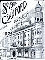
The cover of Souvenir of Cranford (1894) by architect Frank T. Lent
-
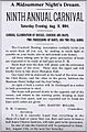
1894 river carnival announcement by the Cranford Boating Association
-
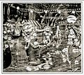
Illustration of Cranford's lantern-lit river carnival in a 1908 edition of Harper's Weekly
-
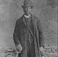
Joshua Bryant (1852–1898) was Cranford's first Black law enforcement officer, the township's first Black elected official, and an influential figure in local politics. He was born in Virginia during slavery and moved to Cranford. Bryant is buried locally in Fairview Cemetery & Arboretum.
-
Cranford TV-35 public access logo
-
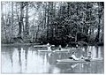
Rowers on the Rahway River in Cranford, c. 1885
-

Cranford's First Presbyterian Church c. 1910
-
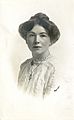
British suffragette Christabel Pankhurst, c. 1910


.jpg)
See also
 In Spanish: Municipio de Cranford (Nueva Jersey) para niños
