
Cressbrook, Queensland facts for kids
Quick facts for kids CressbrookQueensland |
|||||||||||||||
|---|---|---|---|---|---|---|---|---|---|---|---|---|---|---|---|

Cressbrook
Location in Queensland
|
|||||||||||||||
| Population | 117 (2016 census) | ||||||||||||||
| • Density | 4.606/km2 (11.93/sq mi) | ||||||||||||||
| Postcode(s) | 4313 | ||||||||||||||
| Area | 25.4 km2 (9.8 sq mi) | ||||||||||||||
| Time zone | AEST (UTC+10:00) | ||||||||||||||
| Location |
|
||||||||||||||
| LGA(s) | Somerset Region | ||||||||||||||
| State electorate(s) | Nanango | ||||||||||||||
| Federal Division(s) | Blair | ||||||||||||||
|
|||||||||||||||
Cressbrook is a rural locality in the Somerset Region, Queensland, Australia. In the 2016 census Cressbrook had a population of 117 people.
It is known for its recreational aviation facilities.
Geography
Cressbrook is a sparsely populated rural area with land used for crops and grazing; there is no urban centre. It is bounded by the Brisbane River to the north and east. Cressbrook Creek meanders from the west to the east of the locality where it enters the Brisbane River. The Cressbrook-Carboonbah Road traverses from the Brisbane Valley Highway in the north-west through the south-east of the locality towards Mount Beppo and beyond to Carboonbah.
History
The locality of Cressbrook takes its name from the Cressbrook Homestead established by David Cannon McConnel in 1841, who came from the village of Cressbrook in Derbyshire, England.
In 1898, the McConnel family established a condensed milk factory at Cressbrook; it was sold to Nestlé in 1907.
Heritage listings
Cressbrook has a number of heritage-listed sites, including:
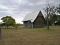
- off Cressbrook-Caboombah Road: Cressbrook Homestead
Watts Bridge Memorial Airfield
The Watts Bridge Memorial Airfield (ICAO: YWSG) is in the south-east of the locality and provides facilities for sports and recreational aviation. There are three grass runways of length 900 metres (3,000 ft), 820 metres (2,690 ft) and 815 metres (2,674 ft). A number of aviation clubs operate from the airfield, flying vintage planes, gyroplanes, gliders, performing acrobatics and skydiving. Many recreational aviation events are held each year at the airfield.
The airfield was established in 1942 as part of Australia's defences during World War II and known as the Toogoolawah airfield. After the war, the airfield was no longer needed for defence purposes, the buildings were removed and the land was used for grazing. In the early 1980s, the desire for recreational airfield facilities resulted in a group of recreational pilots re-establishing the runways and taxiways, and reopening the airfield in 1990 as the Watts Bridge Memorial Airfield. The name Watts Bridge is a reference to a nearby bridge that crossed the Brisbane River connecting Silverleigh Road in Cressbrook to Cooeeimbardi Road in Lower Cressbrook and was named after local dairyman James Robert Watts. Having survived many floods of the Brisbane River, the bridge was washed away in the 1974 Brisbane flood and not replaced.
Images for kids
-
Victoria Chapel at the Cressbrook Homestead, 2010

