
Cross County, Arkansas facts for kids
Quick facts for kids
Cross County
|
|
|---|---|
      Clockwise from top: Cross County Courthouse, the railroad overpass in Wynne, Lake Austell at Village Creek State Park, a sorghum field with Wynne grain elevator in the background, a preserved Native American mound at Parkin Archaeological State Park, and streetside in the Wynne Commercial Historic District
|
|

Location within the U.S. state of Arkansas
|
|
 Arkansas's location within the U.S. |
|
| Country | |
| State | |
| Founded | November 15, 1862 |
| Named for | David C. Cross |
| Seat | Wynne |
| Largest city | Wynne |
| Area | |
| • Total | 622.33 sq mi (1,611.8 km2) |
| • Land | 615.85 sq mi (1,595.0 km2) |
| • Water | 6.48 sq mi (16.8 km2) 1.0%% |
| Population
(2010)
|
|
| • Total | 17,870 |
| • Estimate
(2019)
|
16,419 |
| • Density | 28.715/sq mi (11.087/km2) |
| Time zone | UTC−6 (Central) |
| • Summer (DST) | UTC−5 (CDT) |
| Congressional district | 1st |
Cross County is a rural Northeast Arkansas county in the Arkansas Delta. Created as Arkansas's 53rd county on November 15, 1862, Cross County contains four incorporated municipalities, including Wynne, the county seat and most populous city. It is named for Confederate Colonel David C. Cross, a political leader in the area.
The county is largely flat and fertile, mostly used for row agriculture typical of the rich alluvial soils of the Arkansas Delta. Crowley's Ridge, a forested deposit of loess hills rising from the flat Delta bisects the county from north to south, including part of Wynne and most of Village Creek State Park, the county's primary protected area of ecological value. Historical and cultural features range from Parkin Archeological State Park, which preserves a prehistoric Native American mound building settlement, to the Johnston Cotton Gin marking mechanization of the cotton farm, and the Northern Ohio School, a segregated school built by a lumber company for African-American children of employees.
Cross County occupies 622.33 square miles (1,612 ha) and contained a population of 17,870 people in 6,653 households as of the 2010 census, ranking it 49th in size and 43rd in population among the state's 75 counties. The economy is largely based on agriculture. Poverty and unemployment rates are above national averages, household incomes are below state and national averages. Politically, Cross County has transitioned from reliably Democratic to steadily Republican since the mid-20th century.
Cross County is mostly served by two school districts: Cross County School District and Wynne Public Schools. Higher education is provided at the Wynne campus of East Arkansas Community College, a public community college. Crossridge Community Hospital in Wynne is a community hospital providing primary care in the county. Although no Interstate highways serve Cross County, the county has access to two United States highways (US Highway 49 [US 49] and US 64) and thirteen Arkansas state highways. Cross County is also served by one public owned/public use general aviation airport, Wynne Municipal Airport, and seven community water systems provide potable water to customers in the county.
Contents
Geography
According to the U.S. Census Bureau, the county has a total area of 622 square miles (1,610 km2), of which 616 square miles (1,600 km2) is land and 5.9 square miles (15 km2) (1.0%) is water.
Major highways
 U.S. Highway 49
 U.S. Highway 64
 Highway 1
 Highway 42
 Highway 75
Adjacent counties
- Poinsett County (north)
- Crittenden County (east)
- St. Francis County (south)
- Woodruff County (west)
- Jackson County (northwest)
Demographics
| Historical population | |||
|---|---|---|---|
| Census | Pop. | %± | |
| 1870 | 3,915 | — | |
| 1880 | 5,050 | 29.0% | |
| 1890 | 7,693 | 52.3% | |
| 1900 | 11,051 | 43.7% | |
| 1910 | 14,042 | 27.1% | |
| 1920 | 18,579 | 32.3% | |
| 1930 | 25,723 | 38.5% | |
| 1940 | 26,046 | 1.3% | |
| 1950 | 24,757 | −4.9% | |
| 1960 | 19,551 | −21.0% | |
| 1970 | 19,783 | 1.2% | |
| 1980 | 20,434 | 3.3% | |
| 1990 | 19,225 | −5.9% | |
| 2000 | 19,526 | 1.6% | |
| 2010 | 17,870 | −8.5% | |
| 2019 (est.) | 16,419 | −8.1% | |
| U.S. Decennial Census 1790–1960 1900–1990 1990–2000 2010–2016 |
|||

2020 census
| Race | Num. | Perc. |
|---|---|---|
| White | 12,067 | 71.69% |
| Black or African American | 3,651 | 21.69% |
| Native American | 38 | 0.23% |
| Asian | 102 | 0.61% |
| Pacific Islander | 5 | 0.03% |
| Other/Mixed | 618 | 3.67% |
| Hispanic or Latino | 352 | 2.09% |
As of the 2020 United States Census, there were 16,833 people, 6,653 households, and 4,652 families residing in the county.
Communities
Cities
- Cherry Valley
- Hickory Ridge
- Parkin
- Wynne (county seat)
Unincorporated communities
Townships

Townships in Arkansas are the divisions of a county. Each township includes unincorporated areas; some may have incorporated cities or towns within part of their boundaries. Arkansas townships have limited purposes in modern times. However, the United States Census does list Arkansas population based on townships (sometimes referred to as "county subdivisions" or "minor civil divisions"). Townships are also of value for historical purposes in terms of genealogical research. Each town or city is within one or more townships in an Arkansas county based on census maps and publications. The townships of Cross County are listed below; listed in parentheses are the cities, towns, and/or census-designated places that are fully or partially inside the township.
- Bedford (small part of Wynne)
- Brushy Lake
- Coldwater
- Ellis
- Fair Oaks
- Hickory Ridge (Hickory Ridge)
- Mitchell (Cherry Valley)
- Searcy
- Smith
- Twist
- Tyronza (Parkin)
- Wynne (most of Wynne)
Infrastructure
Major highways
Cross County is not served by any Interstate highways; the nearest access to the Interstate system is Interstate 40 (I-40) in St. Francis County to the south. Two United States highways serve Cross County: U.S. Highway 49 (US 49) runs north–south in western Cross County; and US 64 runs east–west across the length of Cross County.

Eleven state highways serve the traveling public in the county, varying from short connector routes to long highways traversing the entire county. Highway 1, which runs north–south the length of the Arkansas Delta, essentially bisects the county, serving as a principal arterial through Wynne and connecting Cherry Valley and Vanndale to the state highway system. Highway 42 runs east–west across the northern part of Cross County through Hickory Ridge, Cherry Valley, Birdeye, Coldwater, and Twist. Highway 75 runs north–south though east Cross County, connecting Parkin and Coldwater to I-40 to the south and I-555 to the north.
Highway 163 begins at Wittsburg and runs north along Crowley's Ridge to Birdeye and toward Jonesboro. It is designated as the Crowley's Ridge Parkway, a National Scenic Byway and Arkansas Scenic Byway.
Utilities

Entergy Arkansas is the sole provider of electricity in most of Cross County, with exception of an area northeast of Wynne roughly between Highway 1 and the St. Francis River, which is served by Woodruff Electric Cooperative. Telephone communication service is provided by AT&T, cable television is provided by East Arkansas Video. Centerpoint Energy is the natural gas utility in Cross County.
The Arkansas Department of Health (ADH) is responsible for the regulation and oversight of public water systems throughout the state. Cross County contains seven community water systems. Cross County Rural Water System is the largest by customer count (9276), though it extends into portions of five other counties. Wynne Water Utilities is largest by customers in Cross County (8837), followed by the Vanndale-Birdeye Water Association (2389). Cherry Valley Waterworks, Hickory Ridge Waterworks, Parkin Rural Water Association, and Parkin Water Company are all smaller water systems with under 1000 customers. All use groundwater from various aquifers as source water.
Images for kids
-
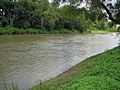
St. Francis River at Parkin
-
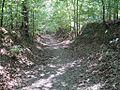
This segment of the Memphis to Little Rock Road in Village Creek State Park is listed on the National Register of Historic Places and is preserved as a trail
-
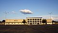
EACC-Wynne
-
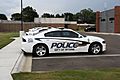
Wynne Police Department patrol car
-
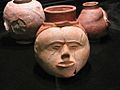
Native American pottery found nearby on display at Parkin Archaeological State Park
-
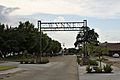
Entrance to downtown Wynne
-
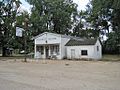
The W.M. Smith & Sons store was the historic center of the Birdeye community


See also
 In Spanish: Condado de Cross para niños
