
Crossdale, Queensland facts for kids
Quick facts for kids CrossdaleQueensland |
|||||||||||||||
|---|---|---|---|---|---|---|---|---|---|---|---|---|---|---|---|

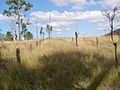
Paddocks along Wivenhoe Somerset Dam Road, 2015
|
|||||||||||||||

Crossdale
Location in Queensland
|
|||||||||||||||
| Population | 75 (2016 census) | ||||||||||||||
| • Density | 0.658/km2 (1.70/sq mi) | ||||||||||||||
| Postcode(s) | 4312 | ||||||||||||||
| Area | 114.0 km2 (44.0 sq mi) | ||||||||||||||
| Time zone | AEST (UTC+10:00) | ||||||||||||||
| Location |
|
||||||||||||||
| LGA(s) | Somerset Region | ||||||||||||||
| State electorate(s) | Nanango | ||||||||||||||
| Federal Division(s) | Blair | ||||||||||||||
|
|||||||||||||||
Crossdale is a rural locality in the Somerset Region, Queensland, Australia. In the 2016 census Crossdale had a population of 75 people.
Geography

Part of the western boundary of Crossdale follows the Stanley River. Some of the waters of Somerset Dam are within the locality. Crossdale is relatively large and has a diverse topography. In the north east the elevations rises along the north of the D'Aguilar Range. Little Mount Brisbane is located close to the Somerset Dam wall. In the south another hilly area reaches heights greater than 300 m around McKey Hill. A majority of the locality is devoid of vegetation although the slopes remain covered by bushland.
Education
There are no schools in Crossdale. The nearest primary schools are Toogoolawah State School in Toogoolawah to the west and Fernvale State School in Fernvale to the south-west. The nearest secondary schools are Toogoolawah State High School in Toogoolawah to the west and Kilcoy State High School in Kilcoy to the north.
Images for kids
-
Bryden-Fairview cemetery, 2010

