
Cumberland County, New Jersey facts for kids
Quick facts for kids
Cumberland County
|
|||
|---|---|---|---|

Downtown Bridgeton
|
|||
|
|||

Location within the U.S. state of New Jersey
|
|||
 New Jersey's location within the U.S. |
|||
| Country | |||
| State | |||
| Founded | 1748 | ||
| Named for | Prince William, Duke of Cumberland | ||
| Seat | Bridgeton | ||
| Largest municipality | Vineland (population) Maurice River Township (area) |
||
| Area | |||
| • Total | 677.62 sq mi (1,755.0 km2) | ||
| • Land | 483.70 sq mi (1,252.8 km2) | ||
| • Water | 193.92 sq mi (502.3 km2) 28.62% | ||
| Population
(2020)
|
|||
| • Total | 154,152 | ||
| • Density | 227.4903/sq mi (87.8345/km2) | ||
| Congressional district | 2nd | ||


Cumberland County is a coastal county located on the Delaware Bay in the U.S. state of New Jersey. As of the 2020 United States Census, the county's population was 154,152, making it the 16th-largest of the state's 21 counties. Its county seat is Bridgeton. Cumberland County is named for Prince William, Duke of Cumberland. The county was formally created from portions of Salem County as of January 19, 1748.
This county is part of the Vineland-Millville-Bridgeton Primary Metropolitan Statistical Area as well as the Delaware Valley Combined Statistical Area.
Contents
Geography
According to the 2010 Census, the county had a total area of 677.62 square miles (1,755.0 km2), including 483.70 square miles (1,252.8 km2) of land (71.4%) and 193.92 square miles (502.3 km2) of water (28.6%).
Cumberland is a low-lying, generally featureless coastal county, with many salt marshes near the Delaware Bay. The highest elevation is at one of 12 areas in Upper Deerfield Township that stand approximately 140 feet (43 m) above sea level; the lowest elevation is sea level.
Adjacent counties
- Gloucester County, New Jersey – north
- Atlantic County, New Jersey – northeast
- Cape May County, New Jersey – southeast
- Kent County, Delaware – southwest1
- Salem County, New Jersey – northwest
1across Delaware Bay; no land border
Demographics
| Historical population | |||
|---|---|---|---|
| Census | Pop. | %± | |
| 1790 | 8,248 | — | |
| 1800 | 9,529 | 15.5% | |
| 1810 | 12,670 | 33.0% | |
| 1820 | 12,668 | 0.0% | |
| 1830 | 14,093 | 11.2% | |
| 1840 | 14,374 | 2.0% | |
| 1850 | 17,189 | 19.6% | |
| 1860 | 22,605 | 31.5% | |
| 1870 | 34,665 | 53.4% | |
| 1880 | 37,687 | 8.7% | |
| 1890 | 45,438 | 20.6% | |
| 1900 | 51,193 | 12.7% | |
| 1910 | 55,153 | 7.7% | |
| 1920 | 61,348 | 11.2% | |
| 1930 | 69,895 | 13.9% | |
| 1940 | 73,184 | 4.7% | |
| 1950 | 88,597 | 21.1% | |
| 1960 | 106,850 | 20.6% | |
| 1970 | 121,374 | 13.6% | |
| 1980 | 132,866 | 9.5% | |
| 1990 | 138,053 | 3.9% | |
| 2000 | 146,438 | 6.1% | |
| 2010 | 156,898 | 7.1% | |
| 2020 | 154,152 | −1.8% | |
| Historical sources: 1790-1990 1970-2010 2020 |
|||
2020 Census
As of the 2020 United States census, the county's had 154,152 people, 51,360 households, and 34,309 families. The population density was 318.7 inhabitants per square mile (123.1/km2). There were 57,119 housing units at an average density of 118 per square mile (45.6/km2). The racial makeup was 45.4% White, 18.0% African American, 0.9% Native American, 1.2% Asian, and 2.6% from two or more races. Hispanic or Latino of any race were 34.4% of the population.
Of the 51,360 households, of which 26.8% had children under the age of 18 living with them, 38.9% were married couples living together, 18.4% had a female householder with no husband present, 9.3% had a male householder with no wife present and 33.2% were non-families, and 12.1% had someone living alone who was 65 years of age or older. The average household size was 2.68 and the average family size was 3.30.
About 23.8% of the population was under age 18, 7.5% was from age 18 to 24, 39.3% was from age 15 to 44, and 15.7% was age 65 or older. The median age was 38.1 years. The gender makeup was 51.7% male and 48.3% female. For every 100 females, there were 107.1 males.
The median household income was $54,587, and the median family income was $65,022. About 13.2% of the population were below the poverty line, including 17.1% of those under age 18 and 10.4% of those age 65 or over.
2010 Census
As of the census of 2010, there were 156,898 people, 51,931 households, and 36,559 families residing in the county. The population density was 324.4 per square mile (125.3/km2). There were 55,834 housing units at an average density of 115.4 per square mile (44.6/km2)*. The racial makeup of the county was 62.74% (98,430) White, 20.23% (31,741) Black or African American, 1.11% (1,746) Native American, 1.22% (1,907) Asian, 0.04% (59) Pacific Islander, 11.15% (17,492) from other races, and 3.52% (5,523) from two or more races. [[Hispanic (U.S. Census)|Hispanic or Latino of any race were 27.06% (42,457) of the population.
There were 51,931 households out of which 31.4% had children under the age of 18 living with them, 45.2% were married couples living together, 18.6% had a female householder with no husband present, and 29.6% were non-families. 24% of all households were made up of individuals, and 10.8% had someone living alone who was 65 years of age or older. The average household size was 2.79 and the average family size was 3.26.
In the county, the population was spread out with 24% under the age of 18, 9.5% from 18 to 24, 28.5% from 25 to 44, 25.3% from 45 to 64, and 12.6% who were 65 years of age or older. The median age was 36.5 years. For every 100 females there were 106.2 males. For every 100 females ages 18 and old there were 106.9 males.
Municipalities

Municipalities in Cumberland County (with most 2010 Census data for population, housing units and area) are:
| Municipality (with map key) |
Municipal type |
Population | Housing Units |
Total Area |
Water Area |
Land Area |
Pop. Density |
Housing Density |
Communities |
|---|---|---|---|---|---|---|---|---|---|
| Bridgeton (3) | city | 25,349 | 6,782 | 6.43 | 0.25 | 6.18 | 4,102.5 | 1,097.6 | |
| Commercial Township (13) | township | 5,178 | 2,115 | 34.44 | 2.31 | 32.13 | 161.2 | 65.8 | Laurel Lake (2,989) Port Norris (1,377) |
| Deerfield Township (9) | township | 3,119 | 1,143 | 16.80 | 0.03 | 16.76 | 186.1 | 68.2 | Rosenhayn (1,098) |
| Downe Township (12) | township | 1,585 | 996 | 54.27 | 5.66 | 48.61 | 32.6 | 20.5 | |
| Fairfield Township (10) | township | 6,295 | 2,058 | 43.95 | 2.69 | 41.26 | 152.6 | 49.9 | Fairton (1,064) |
| Greenwich Township (6) | township | 804 | 369 | 18.83 | 1.00 | 17.84 | 45.1 | 20.7 | Springtown |
| Hopewell Township (7) | township | 4,571 | 1,741 | 30.83 | 0.95 | 29.87 | 153.0 | 58.3 | |
| Lawrence Township (11) | township | 3,290 | 1,221 | 38.33 | 1.41 | 36.92 | 89.1 | 33.1 | Cedarville (776) |
| Maurice River Township (14) | township | 7,976 | 1,506 | 95.76 | 2.65 | 93.11 | 85.7 | 16.2 | |
| Millville (2) | city | 28,400 | 11,435 | 44.49 | 2.49 | 42.00 | 676.2 | 272.3 | |
| Shiloh (4) | borough | 516 | 214 | 1.21 | 0.00 | 1.21 | 427.3 | 177.2 | |
| Stow Creek Township (5) | township | 1,431 | 568 | 18.85 | 0.55 | 18.30 | 78.2 | 31.0 | Garrison Corner Jericho Kernan Corner Roadstown |
| Upper Deerfield Township (8) | township | 7,660 | 3,025 | 31.27 | 0.18 | 31.10 | 246.3 | 97.3 | Seabrook Farms (1,484) |
| Vineland (1) | city | 60,724 | 22,661 | 69.03 | 0.61 | 68.42 | 887.5 | 331.2 | |
| Cumberland County | county | 156,898 | 55,834 | 677.62 | 193.92 | 483.70 | 324.4 | 115.4 |
Transportation
Airports
The following public-use airports are located in Cumberland County:
- Bucks Airport (00N) in Bridgeton
- Millville Municipal Airport (MIV) in Millville
- Kroelinger Airport (29N) in Vineland
Roads and highways
As of 2010[update], the county had a total of 1,271.74 miles (2,046.67 km) of roadways, of which 643.65 miles (1,035.85 km) were maintained by the local municipality, 539.14 miles (867.66 km) by Cumberland County and 88.95 miles (143.15 km) by the New Jersey Department of Transportation.
Cumberland is served only by state and county routes. Major county routes that pass through include County Route 540, County Route 548 (only in Maurice River Township), County Route 550, County Route 552, County Route 553 and County Route 555.
State routes include Route 47, Route 49, Route 55, Route 56, Route 77 and Route 347.
Route 55 is the only limited access road in the county which provides access to I-76, Interstate 295, and the Philadelphia area to the north.
Climate and weather
| Weather chart for Bridgeton, New Jersey | |||||||||||||||||||||||||||||||||||||||||||||||
|---|---|---|---|---|---|---|---|---|---|---|---|---|---|---|---|---|---|---|---|---|---|---|---|---|---|---|---|---|---|---|---|---|---|---|---|---|---|---|---|---|---|---|---|---|---|---|---|
| J | F | M | A | M | J | J | A | S | O | N | D | ||||||||||||||||||||||||||||||||||||
|
3.6
41
25
|
2.9
44
28
|
4.3
52
34
|
4
63
43
|
3.8
73
53
|
4.2
82
63
|
4.1
87
68
|
4.1
85
66
|
4.3
78
59
|
3.6
67
47
|
3.3
56
39
|
4
45
30
|
||||||||||||||||||||||||||||||||||||
| temperatures in °F precipitation totals in inches source: The Weather Channel |
|||||||||||||||||||||||||||||||||||||||||||||||
|
Metric conversion
|
|||||||||||||||||||||||||||||||||||||||||||||||
In recent years, average temperatures in the county seat of Bridgeton have ranged from a low of 25 °F (−4 °C) in January to a high of 87 °F (31 °C) in July, although a record low of −13 °F (−25 °C) was recorded in January 1985 and a record high of 101 °F (38 °C) was recorded in July 1966. Average monthly precipitation ranged from 2.94 inches (75 mm) in February to 4.30 inches (109 mm) in March.
Economy
Based on data from the Bureau of Economic Analysis, Cumberland County had a gross domestic product (GDP) of $6.1 billion in 2018, which was ranked 17th in the state and represented an increase of 1.6% from the previous year.
Images for kids
-
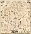
1862 map

See also
 In Spanish: Condado de Cumberland (Nueva Jersey) para niños
