
Cumberland Plain Woodland facts for kids
Quick facts for kids Cumberland Plain Woodland |
|
|---|---|

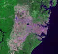
The Cumberland Plain Woodland region lies far-west of Sydney (light pink on map).
|
|
| Ecology | |
| Realm | Australasia |
| Biome | Temperate grasslands, savannas, and shrublands, Mediterranean forests |
| Borders | Eastern Australian temperate forests |
| Geography | |
| Country | Australia |
| Elevation | 10–100 metres (33–328 ft) |
| Coordinates | 33°50′59″S 150°54′40″E / 33.84972°S 150.91111°E |
| Geology | Sandstone, shale, laminite and siltstone |
| Climate type | Humid subtropical climate (Cfa) |
| Soil types | Clay, sand (podsol), loam |
The Cumberland Plain Woodland is one of six main indigenous woodland communities of Sydney, New South Wales, Australia, that comprises an open tree canopy, a groundcover with grasses and herbs, usually with layers of shrubs and/or small trees. Situated in the Cumberland Plain, it is made up of dry sclerophyll woodlands, grasslands and/or forests, reminiscent of Mediterranean forests and temperate grasslands.
According to Office of Environment and Heritage, the community falls predominantly within the Coastal Valley Grassy Woodlands region, which are part of the Grassy Woodlands formation found in the eastern corridor New South Wales, barring the coastline.
Currently, less than 6% of the Woodlands remain in small parts distributed across the western suburbs of Sydney, totaling only around 6400 hectares. Cumberland Plain Woodland was listed as an Endangered Ecological Community under the Threatened Species Conservation Act 1995 in June 1997. The greatest threats to the Cumberland Plain Woodland include land clearing for agriculture, urban sprawl and the introduction of harmful weed species.
Contents
Geography
_-_Adams_Road.JPG)
In 1877, Cumberland Plain Woodlands covered 107,000 hectares and filled around 30% of the Sydney Basin. At the time of European settlement, the Cumberland Plain contained 1,070 km² of woodlands and forests. The westward expansion of Sydney over the plain has placed enormous pressure on the woodlands and other local ecological communities, only 13% of which remain uncleared.
Situated in the cities of Fairfield, Liverpool, Cumberland, Campbelltown, Blacktown and Penrith, and surrounds, they contain approximately 2000 ha (one-fifth) of the remaining Cumberland Plain Woodland. The ecoregion contains clay soils derived from Wianamatta Shale. The ecoregion is located on a rain shadow area, usually getting 700–900 mm of annual rainfall, to the west of Sydney CBD. Its range does not extend to slightly wetter Sydney Turpentine-Ironbark Forest, or high-rainfall ridges (such as Blue Gum High Forest in the upper North Shore).
The biotic community is mostly found on flat or hilly terrains up to about 350 m in elevation, but it may also be present on locally precipitous sites and at slightly higher elevations. Some parts of the community may have a forest structure. The Woodland features an open tree canopy, groundcover prevailed by grasses and herbs, sometimes with layers of shrubs and small trees.
Examples of the remnants can be seen at Scheyville National Park, Rosford Street Reserve, Brenan Park, Central Gardens Nature Reserve, Fairfield Park Precinct, Kemps Creek, Mulgoa, Prospect Hill in Pemulwuy, Prospect Nature Reserve, Wetherill Park Nature Reserve and Chipping Norton Lake, among other places.
Ecoregions

_Airport_site_-_Longleys_Rd.JPG)


The Cumberland Plain Woodland, classed under Coastal Valley Grassy Woodlands, includes these ecoregions in its realm, with some overlapping and others plainly being sub-ecoregions of the Woodland:
- Cumberland Moist Shale Woodlands – Located in protected areas, they have waxy-leaved shrubs and small trees in the understorey with a ground cover of herbs, fleshy twiners and grasses, which are usually absent in the surrounding grassy woodlands. Having hints, and being a component, of Western Sydney Dry Rainforest, some of its species would include hairy clerodendrum (Clerodendrum tomentosum) and slender grape (Cayratia clematidea). Although most of its habitat has been cleared for housing and urbanization, there are pockets of it in the southwest parts of the Fairfield City Council area and northwest of Liverpool near Green Valley and Cecil Hills.
- Cumberland Shale Hills Woodland – It's one of the widespread grassy woodland communities within Cumberland Plain Woodland and is restricted to mean annual rainfall of between 750 and 900 millimetres and elevations between 50 and 350 metres above sea level. An open woodland mainly containing grey box (Eucalyptus moluccana and Eucalyptus microcarpa) and forest red gum trees, it is mostly prevalent in Prospect near Prospect Reservoir, and also on the western edges of Fairfield City, Campbelltown LGA and Liverpool LGA.
- Cumberland Shale Plains Woodland – Featuring a soft topography, it is an open grassy woodland mainly containing grey boxes, forest red gums and ironbarks. Spotted gum (Corymbia maculata) may occur in the Fairfield LGA. It also contains a thin to reasonable cover of shrubs and a high cover of grasses and forbs. It is mostly spread in around Wetherill Park in Fairfield LGA, Prospect and Greystanes in Blacktown LGA, Cecils Hills and to the southwest as well, in Liverpool LGA.
- Western Sydney dry rainforest – Predominantly cleared within the Cumberland Plain and a component of Moist Shale Woodlands, it occurs on the secured clay-rich soils of the wavy hills and ranges of western Sydney in around Abbotsbury near Calmsley Hill City Farm, albeit in a very small isolated pocket. Grey myrtle (Backhousia myrtifolia) is the most prevalent species with a ground cover being sparsely made up of herbs and ferns. Other salient species include fig (Ficus rubiginosa), wild quince (Alectryon subcinereus) and whalebone tree (Streblus brunonianus). The rainforest canopy may include spotted gums, wattles and paperbarks. Shrubs such as hairy clerodendrum (Clerodendrum tomentosum) and large mock olive (Notelaea longifolia) are also present. Rainfall is usually below 900 millimeters per annum in the rainforests within Cumberland Plain.
- Cumberland Shale-Sandstone Ironbark Forest – Found on the peripheries of the Cumberland Plain, it is one of a series of woodlands that are associated with the impalpable transition between clay-rich shale soil and the coarse sandy substrates of the sandstone plateau. It is present on the western bounds of the Woronora Plateau and above the Nepean and Georges rivers between Appin and the Holsworthy defence area. It is a modestly tall eucalyptus forest with a mixed understorey of sclerophyll shrubs and grasses with some sparse blanket of tall casuarinas (Allocasuarina littoralis and Allocasuarina torulosa). Its ground cover contains varies species of shrubs that are common on shale substrates such as blackthorn (Bursaria spinosa) and those linked with sandstone soils such as geebungs (Persoonia).
- Shale/Sandstone Transition Forest – Found in Ingleburn to the west of the Woronora Plateau in south-western Sydney, at the edges of the Cumberland Plain, in an area with relatively low rainfall (800mm-900mm), it is a moderately tall eucalyptus forest that's linked with the subtle transition between clay-rich shale soil and the rough sandy matter of the sandstone plateau.
- Shale gravel transition forest – Low in fertility and contains shale-influenced sandy soils that support a constituents of ironstone gravels, it is a forest with an understorey that may deviate between dense shrubs and a low thin shrub with an abundant ground cover of grasses. It is mostly found in Prospect, Marsden Park, Holsworthy and near Bankstown.
Vegetation


The sclerophyll woodlands are situated on a nutrient-poor alluvium deposited by the Nepean River from sandstone and shale bedrock in the Blue Mountains. Despite this, they support a tremendous regional biodiversity.
Cumberland Plain Woodland are dominated by Grey Box (Eucalyptus moluccana) and Forest Red Gum (E. tereticornis), with Narrow-leaved Ironbark (Eucalyptus crebra), Spotted Gum (Corymbia maculata) and Thin-leaved Stringybark (Eucalyptus eugenioides) occurring sporadically. The ecoregion may have an open layer of small trees that would include such species of Acacia decurrens, Acacia parramattensis, Acacia implexa and Exocarpos cupressiformis. The shrub layer is mainly contains Bursaria spinosa, indigofera australis, Hardenbergia violacea, Daviesia ulicifolia, Lespedeza cuneata, Dillwynia, Dodonaea viscosa, with plenty grasses such as Kangaroo Grass (Themeda australis) and Weeping Meadow Grass (Microlaena stipoides).
Other eucalyptus species within the Woodland include:
- Eucalyptus amplifolia (cabbage gum)
- Eucalyptus sieberi (Silvertop Ash)
- Eucalyptus oblonga (stringybark)
- Eucalyptus capitellata (brown stringybark)
- Corymbia gummifera (red bloodwood)
- Eucalyptus racemosa (scribbly gum)
- Eucalyptus baueriana (round leaf box)
- Eucalyptus longifolia (woollybutt)
- Eucalyptus paniculata (grey ironbark)
- Eucalyptus punctata (grey gum)
- Eucalyptus melliodora (yellow box)
Non-eucalyptus trees:
- Melaleuca alternifolia (snow-in-summer)
- Melaleuca decora (white feather honeymyrtle)
- Melaleuca styphelioides (prickly-leaved paperbark)
- Alectryon subcinereus (native quince)
- Allocasuarina torulosa (forest oak)
- Tristaniopsis laurina (water gum)
- Melia azedarach (chinaberry tree)
- Backhousia myrtifolia (carrol ironwood)
- Notelaea longifolia (large mock-olive)
- Casuarina cunninghamiana
- Syncarpia glomulifera (turpentine tree)
- Clerodendrum tomentosum (hairy clairy)
- Bursaria spinosa
- Melicytus dentatus (tree violet)
- Acacia floribunda (white sallow wattle)
- Angophora bakeri (narrow-leaved)
- Angophora subvelutina (broad-leaved apple)
Shrubs:
- Pittosporum revolutum (yellow pittosporum)
- Solanum prinophyllum (forest nightshade)
- Breynia oblongifolia (coffee bush)
- Dichondra repens (kidney weed)
- Ajuga australis (Austral bugle)
- Daucus glochidiatus (Australian carrot)
- Centella asiatica (Asiatic pennywort)
- Solanum cinereum (Narrawa burr)
- Crassula sieberiana (Australian stonecrop)
- Aphanopetalum resinosum (gum vine)
- Pandorea pandorana (Wonga Wonga vine)
- Cayratia clematidea (native grape)
- Cheilanthes distans (bristly cloak fern)
- Chrysocephalum apiculatum (yellow buttons)
- Pratia purpurascens (white root)
- Arthropodium milleflorum (pale vanilla lily)
- Chenopodium hastatum (berry Saltbush)
- Schenkia spicata
- Veronica plebeia (trailing speedwell)
- Stackhousia viminea
- Cestrum nocturnum (night-blooming jasmine)
- Rubus parvifolius (Australian raspberry)
- Ozothamnus diosmifolius (rice flower)
- Glycine tabacina (variable glycine)
Grasses and sedge:
- Cyperus gracilis (slender flat sedge)
- Oplismenus hirtellus (basket grass)
- Bothriochloa macra (red-leg grass)
- Fimbristylis dichotoma (eight day grass)
- Panicum effusum (hairy panic)
- Sorghum leiocladum (wild sorghum)
- Chloris truncata (Australian fingergrass)
Wildlife
Bird species in the woodland include (which are mostly vulnerable and/or endangered):

- Gang Gang Cockatoo
- Glossy Black-cockatoo
- Brown Treecreeper
- Painted Honeyeater
- Swift Parrot
- Square-tailed Kite
- Hooded Robin
- Black-chinned Honeyeater
- Turquoise Parrot
- Barking Owl
- Powerful Owl
- Speckled Warbler
- Diamond Firetail
- Masked Owl
- Sooty Owl
- Regent Honeyeater
Mammals:
.jpg)
- Large-eared Pied Bat
- Spotted-tail Quoll
- Eastern False Pipistrelle
- Eastern Bent-wing Bat
- Eastern Freetail Bat
- Large-footed Myotis
- Yellow-bellied Glider
- Squirrel Glider
- Koala
- Yellow-bellied sheath-tailed bat
- Greater Broad-nosed Bat
Images for kids
-
The Cumberland Plain Woodland region lies far-west of Sydney CBD.
