Readington Township, New Jersey facts for kids
Quick facts for kids
Readington Township, New Jersey
|
|
|---|---|
|
Township
|
|
| Township of Readington | |
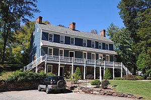
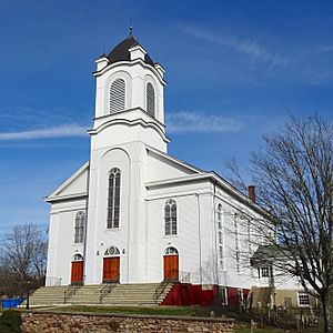
House in Darts Mills
|
|
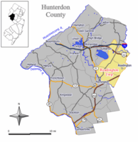
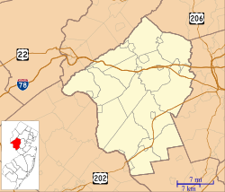
Map of Readington Township in Hunterdon County. Inset: Location of Hunterdon County highlighted in the State of New Jersey.
|
|
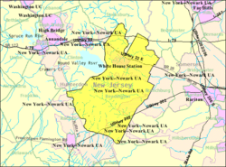
Census Bureau map of Readington Township, New Jersey
|
|
| Country | |
| State | |
| County | |
| Royal charter | July 15, 1730 |
| Incorporated | February 21, 1798 |
| Named for | John Reading |
| Government | |
| • Type | Township |
| • Body | Township Committee |
| Area | |
| • Total | 47.83 sq mi (123.88 km2) |
| • Land | 47.56 sq mi (123.17 km2) |
| • Water | 0.27 sq mi (0.70 km2) 0.57% |
| Area rank | 34th of 565 in state 1st of 26 in county |
| Elevation | 213 ft (65 m) |
| Population | |
| • Total | 16,126 |
| • Estimate
(2019)
|
15,843 |
| • Rank | 157th of 566 in state 2nd of 26 in county |
| • Density | 337.8/sq mi (130.4/km2) |
| • Density rank | 468th of 566 in state 15th of 26 in county |
| Time zone | UTC−05:00 (Eastern (EST)) |
| • Summer (DST) | UTC−04:00 (Eastern (EDT)) |
| ZIP Code |
08870 - Readington
08888 - Whitehouse 08889 - Whitehouse Station |
| Area code(s) | 908 |
| FIPS code | 3401962250 |
| GNIS feature ID | 0882178 |
| Website | |
Readington Township is a township located in the easternmost portion of Hunterdon County, New Jersey, United States. As of the 2010 United States Census, the township's population was 16,126, reflecting an increase of 323 (+2.0%) from the 15,803 counted in the 2000 Census, which had in turn increased by 2,403 (+17.9%) from the 13,400 counted in the 1990 Census.
Created by Royal charter of King George II, "Reading" Township was formed on July 15, 1730, from portions of Amwell Township. It was the first new township created after Hunterdon was established as an independent county. The township was incorporated as Readingtown Township, one of New Jersey's initial group of 104 townships, on February 21, 1798. Portions of the township were annexed by Tewksbury Township in 1832 and 1861. The township was named for John Reading, the first native-born governor of the British Province of New Jersey.
Covering more than 48 square miles (120 km2), it is the largest township in the county, covering almost 11% of the county's area. More than 8,000 acres (32 km2) of land have been preserved from development. Readington Township is bounded on the north by the Lamington River and Rockaway Creek; to the east by Somerset County, which existed as the boundary between East and West Jersey from 1688 to 1695; to the south, the South Branch of the Raritan River; and to the west by the old West Jersey Society's line which crosses the Cushetunk Mountains.
Contents
Geography
According to the United States Census Bureau, the township had a total area of 48.039 square miles (124.421 km2), including 47.736 square miles (123.636 km2) of land and 0.303 square miles (0.784 km2) of water (0.63%).
Whitehouse Station (2010 Census population of 2,089) is an unincorporated community and census-designated place (CDP) located within Readington Township.
The township borders Clinton Township, Raritan Township and Tewksbury Township in Hunterdon County; and Branchburg and Hillsborough Township in Somerset County.
Cushetunk Mountain is a ring-shaped mountain located in Clinton Township. Once an active volcano, the diabase mountain was formed 160 million years ago. The Lenape called the mountain "Cushetunk" meaning "place of hogs". In the 1960s, the valley was filled with water to create Round Valley Reservoir, at 180 feet (55 m) in depth the second-deepest in the state.
Communities
Unincorporated communities, localities and place names located partially or completely within the township include Backers Island, Higginsville, McCrea Mills, Riverside, Rockfellows Mills, Round Mountain, Stovers Mills and Wood Church, as well as the following:
- Barley Sheaf, a former hamlet within Readington Township, also known as Campbellsville and Farmersville
- Centerville, a hamlet that was located on the halfway point on the Swift Sure Stage route between New York City and Philadelphia
- Cushetunk was a village near Cushetunk Mountain and the railroad line
- Darts Mills, a hamlet centered around a former mill complex on the South Branch Raritan River
- Dreahook, a former community near Readington Road and Main Street that was taken from the Dutch word for triangle because of the configuration of the roads at the time
- Holcomb Mills was a community along the South Branch Raritan River
- Mechanicsville, the eastern section of Whitehouse Village on the Jersey Turnpike
- New Bromley, was a small community on the Rockaway Creek that was once home to William Paterson
- Pleasant Run, a small community along Pleasant Run (formerly Campbell's Brook)
- Potterstown, a small community at the western edge of the township
- Readington Village, the oldest settled community in the township, along Holland Brook
- Rowland's Mills, a deserted community on the South Branch Raritan River
- Stanton, a small community near Round Mountain that has carried the names of Mount Pleasant, Housel's Hill, Waggoner's Hill and Stanton
- Stilwells, a hamlet one and a half miles south of Whitehouse Station named after the Stilwell family
- Three Bridges, small community that once had a passenger rail station
- Whitehouse, a community on the old Jersey Turnpike, north of Whitehouse Station
- Whitehouse Station, a community in the western section of Readington near Cushetunk Mountain and the location of the township's railroad station
Demographics
| Historical population | |||
|---|---|---|---|
| Census | Pop. | %± | |
| 1810 | 1,717 | — | |
| 1820 | 1,964 | 14.4% | |
| 1830 | 2,102 | 7.0% | |
| 1840 | 2,373 | 12.9% | |
| 1850 | 2,836 | 19.5% | |
| 1860 | 3,076 | 8.5% | |
| 1870 | 3,070 | −0.2% | |
| 1880 | 3,103 | 1.1% | |
| 1890 | 2,813 | −9.3% | |
| 1900 | 2,670 | −5.1% | |
| 1910 | 2,569 | −3.8% | |
| 1920 | 2,525 | −1.7% | |
| 1930 | 2,811 | 11.3% | |
| 1940 | 2,905 | 3.3% | |
| 1950 | 4,080 | 40.4% | |
| 1960 | 6,147 | 50.7% | |
| 1970 | 7,688 | 25.1% | |
| 1980 | 10,855 | 41.2% | |
| 1990 | 13,400 | 23.4% | |
| 2000 | 15,803 | 17.9% | |
| 2010 | 16,126 | 2.0% | |
| 2019 (est.) | 15,843 | −1.8% | |
| Population sources: 1810-1920 1840 1850-1870 1850 1870 1880-1890 1890-1910 1910-1930 1930-1990 2000 2010 |
|||
Census 2010
As of the census of 2010, there were 16,126 people, 5,971 households, and 4,496 families residing in the township. The population density was 337.8 per square mile (130.4/km2). There were 6,191 housing units at an average density of 129.7 per square mile (50.1/km2)*. The racial makeup of the township was 93.09% (15,011) White, 1.33% (214) Black or African American, 0.11% (18) Native American, 3.60% (581) Asian, 0.01% (1) Pacific Islander, 0.77% (124) from other races, and 1.10% (177) from two or more races. [[Hispanic (U.S. Census)|Hispanic or Latino of any race were 3.93% (633) of the population.
There were 5,971 households out of which 35.1% had children under the age of 18 living with them, 66.0% were married couples living together, 6.6% had a female householder with no husband present, and 24.7% were non-families. 20.7% of all households were made up of individuals, and 8.0% had someone living alone who was 65 years of age or older. The average household size was 2.70 and the average family size was 3.15.
In the township, the population was spread out with 25.1% under the age of 18, 5.6% from 18 to 24, 20.4% from 25 to 44, 35.3% from 45 to 64, and 13.5% who were 65 years of age or older. The median age was 44.4 years. For every 100 females there were 96.2 males. For every 100 females ages 18 and old there were 94.1 males.
The Census Bureau's 2006-2010 American Community Survey showed that (in 2010 inflation-adjusted dollars) median household income was $120,821 (with a margin of error of +/- $9,180) and the median family income was $138,171 (+/- $10,232). Males had a median income of $100,647 (+/- $11,576) versus $61,372 (+/- $6,196) for females. The per capita income for the borough was $55,493 (+/- $4,019). About 1.3% of families and 1.9% of the population were below the poverty line, including 2.7% of those under age 18 and 1.7% of those age 65 or over.
Arts and culture
Readington is home to several museums and offers many programs for adults and children. The Bouman-Stickney Homestead is located off of Dreahook Road in the hamlet of Stanton. Coldbrook School, the site of living history programs for the township's elementary school children, is in the northern section of town, and the Eversole-Hall House is located on Route 523, next to the Municipal building. Taylor's Mill was built around 1760 by John Taylor. The township plans to make Taylor's Mill a fourth township museum because it is the only remaining pre-revolutionary mill in the town; the mill provided troops with food during the Revolutionary War.
Transportation
Roads and highways
As of May 2010[update], the township had a total of 178.01 miles (286.48 km) of roadways, of which 145.39 miles (233.98 km) were maintained by the municipality, 19.33 miles (31.11 km) by Hunterdon County and 13.29 miles (21.39 km) by the New Jersey Department of Transportation.
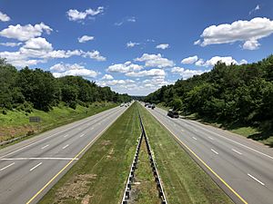
Roads and highways that pass through the township include Interstate 78, U.S. Route 202, Route 22 and Route 31.
Public transportation
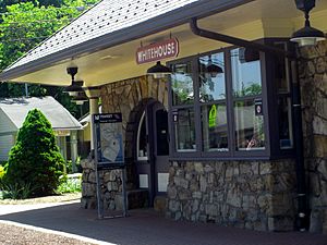
The township is also served by NJ Transit's White House station, offering service on the Raritan Valley Line to Newark Penn Station and Hoboken Terminal, with connecting service to Penn Station New York in Midtown Manhattan.
NJ Transit provides local bus service on the 884 route.
The Hunterdon County LINK provide local bus service on Routes 17 / 18 between Milford and Clinton; and Route 23 between Flemington and Bridgewater Commons Mall / Somerville.
Rail service
The Norfolk Southern Railway's Lehigh Line (formerly the mainline of the Lehigh Valley Railroad), runs through Readington Township.
The Black River and Western Railroad is a freight and heritage railroad that runs from Lambertville via Ringoes and Flemington to Three Bridges (Readington) where it connects to the Norfolk Southern Railway.
Community
The Quick Chek New Jersey Festival of Ballooning celebrated its 30th anniversary in 2012. The event held at Solberg-Hunterdon Airport is the largest summertime hot air balloon festival in North America.
Economy
Readington Township is home to the personal and commercial lines of insurance of Chubb Corp., and the QuickChek Corporation, which operates over 100 convenience stores throughout New Jersey and New York.
Readington was once also home to the global headquarters of Merck & Co., one of the largest pharmaceutical companies in the country, but the company has since relocated to nearby Kenilworth, New Jersey.
Readington's business climate benefits from its proximity to major highways, Princeton, Bridgewater Township and other centers of business in central New Jersey.
Education
The Readington Township Public Schools serve students in pre-kindergarten through eighth grade. As of the 2018–19 school year, the district, comprised of four schools, had an enrollment of 1,495 students and 161.1 classroom teachers (on an FTE basis), for a student–teacher ratio of 9.3:1. Schools in the district (with 2018–19 enrollment data from the National Center for Education Statistics) are Three Bridges School with 318 students in grades PreK-3, Whitehouse School with 304 students in grades K-3, Holland Brook School with 319 students in grades 4-5 and Readington Middle School with 541 students in grades 6–8.
Students in public school for ninth through twelfth grades attend the Hunterdon Central High School, part of the Hunterdon Central Regional High School District, which also serves students in central Hunterdon County from Delaware Township, East Amwell Township, Flemington Borough and Raritan Township. As of the 2018–19 school year, the high school had an enrollment of 2,844 students and 238.8 classroom teachers (on an FTE basis), for a student–teacher ratio of 11.9:1. Seats on the high school district's nine-member board of education are allocated based in the population of the five constituent municipalities who participate in the school district, with three seats allocated to Readington Township.
Eighth grade students from all of Hunterdon County are eligible to apply to attend the high school programs offered by the Hunterdon County Vocational School District, a county-wide vocational school district that offers career and technical education at its campuses in Raritan Township and at programs sited at local high schools, with no tuition charged to students for attendance.
Notable people
People who were born in, residents of, or otherwise closely associated with Readington Township include:
- Emma Bell (born 1986), actress.
- William Cheswick (born c. 1952), computer security and networking researcher, co-author of Firewalls and Internet Security and started the Internet Mapping Project.
- Jack Cust (born 1979), a professional baseball player who played for the Oakland Athletics.
- Bergen Davis (1869–1958), physicist.
- John De Mott (1790–1870), US Congressman from New York State from 1845 to 1847.
- Isaac G. Farlee (1787–1855), member of the United States House of Representatives from New Jersey's 3rd Congressional District from 1843 to 1845.
- Taissa Farmiga (born 1994), actress.
- J. C. Furnas (1906–2001), freelance writer and social historian.
- Robert Greifeld (born 1957), CEO NASDAQ OMX Group.
- John Knowles Herr (1878–1955), Major General and career American soldier who served for 40 years in the United States Cavalry
- Jonathan Jennings (1784–1834), first Governor of Indiana, serving from 1816 to 1822.
- Robyn Kenney (born 1979), field hockey player.
- George H. Large (1850–1939), President of the New Jersey Senate who was the last survivor of the first collegiate football game, played in 1869.
- Howard Lindsay (1889-1968), theatrical producer, playwright, librettist, director and actor.
- Tom Malloy (born 1974), actor and filmmaker.
- William Marchant (1923–1995), playwright and screenwriter, best known for writing the play that served as the basis for the 1957 Walter Lang movie, The Desk Set.
- Ed Martin, politician who served as Chair of the Missouri Republican Party.
- James N. Pidcock (1836–1899), politician who represented New Jersey's 4th congressional district in the United States House of Representatives from 1885 to 1889.
- Martha M. Place (1849–1899), first woman to die in the electric chair.
- Donna Simon (born 1960), politician who has served in the New Jersey General Assembly since 2012, representing the 16th Legislative District.
- Dorothy Stickney (1896–1998), Broadway actress.
See also
 In Spanish: Municipio de Readington (Nueva Jersey) para niños


