
Dalbeg, Queensland facts for kids
Quick facts for kids DalbegQueensland |
|||||||||||||||
|---|---|---|---|---|---|---|---|---|---|---|---|---|---|---|---|

Road signs to Dalberg, 2010
|
|||||||||||||||

Dalbeg
Location in Queensland
|
|||||||||||||||
| Population | 76 (2016 census) | ||||||||||||||
| • Density | 1.895/km2 (4.91/sq mi) | ||||||||||||||
| Postcode(s) | 4807 | ||||||||||||||
| Area | 40.1 km2 (15.5 sq mi) | ||||||||||||||
| Time zone | AEST (UTC+10:00) | ||||||||||||||
| Location |
|
||||||||||||||
| LGA(s) | Shire of Burdekin | ||||||||||||||
| State electorate(s) | Burdekin | ||||||||||||||
| Federal Division(s) | |||||||||||||||
|
|||||||||||||||
Dalbeg is a rural town and locality in the Shire of Burdekin, Queensland, Australia. In the 2016 census, Dalbeg had a population of 76 people.
History
Dalbeg Post Office opened on 1 December 1956 and closed in 1971.
Dalbeg was once home to the North Queensland Soaring Centre (then the Burdekin Soaring Club).
Education
There are no schools in Dalbeg. The nearest government primary school is Millaroo State School in neighbouring Millaroo to the north. There are no government secondary schools nearby; the options are distance education or boarding school.
Images for kids
-
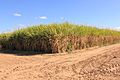
Sugarcane growing in Dalbeg, 2010
-

Irrigation canals, Dalbeg, 2010


All content from Kiddle encyclopedia articles (including the article images and facts) can be freely used under Attribution-ShareAlike license, unless stated otherwise. Cite this article:
Dalbeg, Queensland Facts for Kids. Kiddle Encyclopedia.