Danbury, Iowa facts for kids
Quick facts for kids
Danbury, Iowa
|
|
|---|---|

Location of Danbury, Iowa
|
|
| Country | |
| State | |
| County | Woodbury |
| Area | |
| • Total | 0.41 sq mi (1.05 km2) |
| • Land | 0.41 sq mi (1.05 km2) |
| • Water | 0.00 sq mi (0.00 km2) |
| Elevation | 1,161 ft (354 m) |
| Population
(2020)
|
|
| • Total | 320 |
| • Density | 790.12/sq mi (304.76/km2) |
| Time zone | UTC-6 (Central (CST)) |
| • Summer (DST) | UTC-5 (CDT) |
| ZIP code |
51019
|
| Area code(s) | 712 |
| FIPS code | 19-18390 |
| GNIS feature ID | 0455785 |
Danbury is a city in Woodbury County, Iowa, United States. It is part of the Sioux City, IA–NE–SD Metropolitan Statistical Area. The population was 320 at the time of the 2020 census. Danbury has two churches, St. Mary's Catholic Church and the United Methodist Church. Danbury holds a fall celebration called Corn Days during harvest.
Contents
History
A post office called Danbury has been in operation since 1877. The city was named for both its founder, Daniel Thomas, and the county in which it is located, Woodbury.
Geography
Danbury is located at 42°14′10″N 95°43′18″W / 42.23611°N 95.72167°W (42.236002, -95.721755). It is situated on the Maple River.
According to the United States Census Bureau, the city has a total area of 0.41 square miles (1.06 km2), all of it land.
Demographics
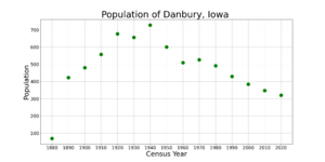
| Historical populations | ||
|---|---|---|
| Year | Pop. | ±% |
| 1880 | 69 | — |
| 1890 | 423 | +513.0% |
| 1900 | 480 | +13.5% |
| 1910 | 558 | +16.3% |
| 1920 | 677 | +21.3% |
| 1930 | 656 | −3.1% |
| 1940 | 728 | +11.0% |
| 1950 | 601 | −17.4% |
| 1960 | 510 | −15.1% |
| 1970 | 527 | +3.3% |
| 1980 | 492 | −6.6% |
| 1990 | 430 | −12.6% |
| 2000 | 384 | −10.7% |
| 2010 | 348 | −9.4% |
| 2020 | 320 | −8.0% |
| Source: and Iowa Data Center Source: |
||
2010 census
As of the census of 2010, there were 348 people, 159 households, and 96 families living in the city. The population density was 848.8 inhabitants per square mile (327.7/km2). There were 185 housing units at an average density of 451.2 per square mile (174.2/km2). The racial makeup of the city was 97.7% White, 1.7% Native American, 0.3% Asian, and 0.3% from two or more races.
There were 159 households, of which 23.3% had children under the age of 18 living with them, 48.4% were married couples living together, 6.9% had a female householder with no husband present, 5.0% had a male householder with no wife present, and 39.6% were non-families. 34.6% of all households were made up of individuals, and 17% had someone living alone who was 65 years of age or older. The average household size was 2.19 and the average family size was 2.81.
The median age in the city was 44.3 years. 23.3% of residents were under the age of 18; 6.6% were between the ages of 18 and 24; 21.8% were from 25 to 44; 25% were from 45 to 64; and 23.3% were 65 years of age or older. The gender makeup of the city was 47.1% male and 52.9% female.
Education
The Maple Valley–Anthon–Oto Community School District operates public schools serving the community.
It was previously a part of the Maple Valley Community School District, established in 1961. On July 1, 2012, the Maple Valley district consolidated with the Anthon–Oto Community School District to form the new Maple Valley–Anthon–Oto district.
See also
 In Spanish: Danbury (Iowa) para niños


