
Davenport, Washington facts for kids
Quick facts for kids
Davenport, Washington
|
|
|---|---|
| City of Davenport | |
.jpg)
Davenport Police Department
|
|

Location of Davenport, Washington
|
|
| Country | United States |
| State | Washington |
| County | Lincoln |
| Area | |
| • Total | 1.67 sq mi (4.32 km2) |
| • Land | 1.67 sq mi (4.32 km2) |
| • Water | 0.00 sq mi (0.00 km2) |
| Elevation | 2,375 ft (724 m) |
| Population
(2010)
|
|
| • Total | 1,734 |
| • Estimate
(2019)
|
1,744 |
| • Density | 1,046.19/sq mi (403.96/km2) |
| Time zone | UTC−8 (Pacific (PST)) |
| • Summer (DST) | UTC−7 (PDT) |
| ZIP code |
99122
|
| Area code(s) | 509 |
| FIPS code | 53-16795 |
| GNIS feature ID | 1504329 |
Davenport is the county seat of Lincoln County, Washington, United States. The population was 1,734 at the 2010 census.
Contents
History
Davenport was first settled in 1880, and was named in 1882 for resident J.C. Davenport. The city was made the county seat of Lincoln County on December 15, 1896, after an election that chosen Davenport over then-seat Sprague, which had been destroyed in a fire, and Harrington.
Davenport was officially incorporated on June 9, 1890. Davenport gained early prominence in the north central part of the Columbia Basin of eastern Washington, with its citizens successfully lobbying to receive the Seattle Lake Shore & Eastern Railway (SLS&E) in 1889 in place of rival Wheatdale. The transcontinental Northern Pacific Railway (NP) established a subsidiary, the Central Washington Railroad (CW), to build a competing railroad line that reached Davenport in February 1889. A branch line of the Great Northern Railway (GN) was built to Davenport from Bluestem in the 1920s.
Davenport is centrally located in the northern wheat belt of the Columbia Basin, where dryland wheat farming on the hills not washed away in the great Missoula Floods some 14,000 years ago, is critical to the agricultural economy of the region. Davenport Union Warehouse and Odessa Union Warehouse operate multiple elevators of varying age and design on the southern part of the city. A few of these structures date to the early days of the city. Davenport still serves as a central collection point for wheat, with most of it shipped out by truck or railcar. While most of the wheat goes to export, some of it does find its way to the ADM flour mills in Spokane and Cheney. Locally grown barley also finds it's way to various west coast breweries and other users.
Primary State Highway #2 (a.k.a. "Sunset Highway") closely followed the CW railroad from Coulee City through Davenport to Spokane. The route is now known as U.S. Route 2, but does not follow the original Sunset Highway in many places. Primary State Highway #7 also intersected with PSH #2 in Davenport, and is now part of State Route 28. PSH #22 ran north from Davenport to the Canada–US border near Northport. This is State Route 25 now.
Geography
Davenport is located at 47°39′4″N 118°9′6″W / 47.65111°N 118.15167°W (47.651157, -118.151627).
According to the United States Census Bureau, the city has a total area of 1.82 square miles (4.71 km2), all of it land.
Climate
Davenport experiences a dry-summer continental climate (Köppen Dsb).
| Climate data for Davenport (1971–2000) | |||||||||||||
|---|---|---|---|---|---|---|---|---|---|---|---|---|---|
| Month | Jan | Feb | Mar | Apr | May | Jun | Jul | Aug | Sep | Oct | Nov | Dec | Year |
| Record high °F (°C) | 58 (14) |
60 (16) |
73 (23) |
90 (32) |
94 (34) |
102 (39) |
105 (41) |
103 (39) |
100 (38) |
86 (30) |
68 (20) |
61 (16) |
105 (41) |
| Average high °F (°C) | 31.1 (−0.5) |
37.3 (2.9) |
47.5 (8.6) |
57.2 (14.0) |
65.8 (18.8) |
73.3 (22.9) |
81.9 (27.7) |
82.8 (28.2) |
72.8 (22.7) |
59.1 (15.1) |
40.7 (4.8) |
31.5 (−0.3) |
56.8 (13.7) |
| Daily mean °F (°C) | 24.9 (−3.9) |
30.2 (−1.0) |
38.0 (3.3) |
45.0 (7.2) |
52.6 (11.4) |
59.2 (15.1) |
65.8 (18.8) |
66.3 (19.1) |
57.3 (14.1) |
45.8 (7.7) |
33.7 (0.9) |
25.3 (−3.7) |
45.3 (7.4) |
| Average low °F (°C) | 18.6 (−7.4) |
23.0 (−5.0) |
28.4 (−2.0) |
32.8 (0.4) |
39.4 (4.1) |
45.0 (7.2) |
49.6 (9.8) |
49.7 (9.8) |
41.8 (5.4) |
32.4 (0.2) |
26.7 (−2.9) |
19.0 (−7.2) |
33.9 (1.0) |
| Record low °F (°C) | −28 (−33) |
−25 (−32) |
−9 (−23) |
18 (−8) |
20 (−7) |
27 (−3) |
29 (−2) |
29 (−2) |
20 (−7) |
−1 (−18) |
−22 (−30) |
−23 (−31) |
−28 (−33) |
| Average precipitation inches (mm) | 1.45 (37) |
1.22 (31) |
1.30 (33) |
1.02 (26) |
1.41 (36) |
1.03 (26) |
0.78 (20) |
0.54 (14) |
0.65 (17) |
0.88 (22) |
1.90 (48) |
1.93 (49) |
14.11 (359) |
| Source: NOAA (normals, 1971–2000) | |||||||||||||
Demographics
| Historical population | |||
|---|---|---|---|
| Census | Pop. | %± | |
| 1890 | 396 | — | |
| 1900 | 1,000 | 152.5% | |
| 1910 | 1,229 | 22.9% | |
| 1920 | 1,112 | −9.5% | |
| 1930 | 987 | −11.2% | |
| 1940 | 1,337 | 35.5% | |
| 1950 | 1,417 | 6.0% | |
| 1960 | 1,494 | 5.4% | |
| 1970 | 1,363 | −8.8% | |
| 1980 | 1,559 | 14.4% | |
| 1990 | 1,502 | −3.7% | |
| 2000 | 1,730 | 15.2% | |
| 2010 | 1,734 | 0.2% | |
| 2019 (est.) | 1,744 | 0.6% | |
| U.S. Decennial Census 2015 Estimate |
|||
2010 census
As of the census of 2010, there were 1,734 people, 694 households, and 445 families residing in the city. The population density was 952.7 inhabitants per square mile (367.8/km2). There were 750 housing units at an average density of 412.1 per square mile (159.1/km2). The racial makeup of the city was 95.3% White, 0.1% African American, 1.2% Native American, 0.1% Asian, 0.1% Pacific Islander, 0.6% from other races, and 2.6% from two or more races. Hispanic or Latino of any race were 2.7% of the population.
There were 694 households, of which 31.1% had children under the age of 18 living with them, 46.8% were married couples living together, 13.5% had a female householder with no husband present, 3.7% had a male householder with no wife present, and 35.9% were non-families. 31.6% of all households were made up of individuals, and 13.9% had someone living alone who was 65 years of age or older. The average household size was 2.43 and the average family size was 3.03.
The median age in the city was 40 years. 25.5% of residents were under the age of 18; 8.7% were between the ages of 18 and 24; 20.9% were from 25 to 44; 25.9% were from 45 to 64; and 19% were 65 years of age or older. The gender makeup of the city was 47.6% male and 52.4% female.
Community
The Davenport School District Includes Davenport Elementary, Davenport Middle School, and Davenport Senior High School. The mascot is the Davenport Gorilla.
Transportation
Davenport is served by the Davenport Municipal Airport. Eastern Washington Gateway Railroad, U.S. Route 2, State Route 28, and State Route 25.
Images for kids
-
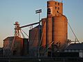
Grain elevators along the railroad in Davenport
-
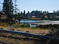
Channeled Scabland terrain west of Davenport
-
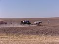
Vintage Harvest Festival in Davenport
-
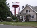
Davenport Water Tower
.jpg)
.jpg)
.jpg)
.jpg)
See also
 In Spanish: Davenport (Washington) para niños
